
 Continue with onX Maps
 Sign in with Facebook


| Elevation: | 4,213 ft | 1,284 m |
| GPS: |
34.0122, -116.16795 Google Map · Climbing Area Map |
|
| Page Views: | 12,804,776 total · 42,049/month | |
| Shared By: | C Miller on Dec 31, 2000 · Updates | |
| Admins: | Greg Opland, C Miller, Gunkswest, Mike Morley, Adam Stackhouse, Salamanizer Ski, Justin Johnsen, Vicki Schwantes |
 Access Issue: Climbing Regulations/Seasonal Raptor Closures
Details
Access Issue: Climbing Regulations/Seasonal Raptor Closures
Details
1. Vegetation is not allowed to be used as an anchor.
2. Only neutral or rock colored bolt hangers are allowed.
For a complete list of climbing rules and closures visit:
nps.gov/jotr/planyourvisit/…
OVERVIEW

Joshua Tree is a world famous area with thousands of routes, countless boulder problems and a very limited number of campsites. Long popular as a winter destination, it's appeal has only grown throughout the years as climbers of all abilities have discovered the mild temperatures, grippy rock and surreal landscape which make it a must visit area on any climber's list. The park has extensive climbing information on the NPS website. Before climbing, always check for route and area closures, especially in the spring when raptors might be nesting.
Today's park visitor comes from around the globe, with some here to climb and others simply here to gaze at the wonder. Looky-loos can crowd some areas during the weekends, but that's part of the Park's mission allowing everyone the opportunity to enjoy the park. Some Joshua Tree climbing history can be found here: JT Climbing Oral History.
In recent years, Joshua Tree's popularity has outgrown its carrying capacity. There are 500 campsites in the park, but camping can become very scarce, very fast. Current prices of overnight camping can be found here, along with other specific campground information. Other overnight options are listed below.
The fee to enter Joshua Tree is currently $30 per vehicle, which is good for 7 days from the date on the receipt. When time permits, the rangers will check the out-going traffic for valid receipts. An annual Joshua Tree pass ($55) or National Parks pass ($80) are also available, and stand as an excellent value for those visiting the park more often. Both are purchased at the check stations at the entrances to the park. Cash and credit cards are accepted.
The rock itself is Monzogranite and tends to be fairly solid, but the less traveled and/or newer routes can have the dreaded "ball bearings underfoot syndrome" making those friction moves a tad more dicey. The best rock sports a coating of "desert varnish" or patina which darkens and solidifies the rock appreciably.
Kudos to this page's founding father Mike Morley.
Park Visitor Information 760-367-5500


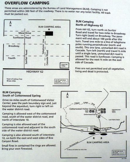
CAMPING
Water is not available in the Park. Please come prepared with water containers if planning on staying more than a day.
* NPS Campground Details - specific information about each campground
* Backcountry camping inside the Park
* BLM land for the squeeze.
* Hipcamp has a great directory of the campgrounds, and for some of them you can even check availability and book them online.


HOTELS, MOTELS, B&Bs & VACATION HOMES

Weekends are crowded during peak season (November-May)! With its proximity to Los Angeles and San Diego, the Park draws more than three million visitors annually. Plan accordingly and have a backup plan if the campgrounds are full. There are numerous inexpensive motels in the nearby towns of Joshua Tree, Yucca Valley, and 29 Palms.
*Holiday Inn Express Hotel & Suites
*Joshua Desert Retreats - Vacation Rentals
*Motel 6;numberOfAdults=&arrivalDate=&departureDate=&BTR=&redicardNumber=&corporatePlusNumber=&travelAgentNumber=
Roughley Manor Bed and Breakfast Inn: Websites down, but give them a call at (760) 367-3238
SHOWERS
Showers are available at:
73782 2 Mile Rd, Twentynine Palms, CA 92277
(760) 361-8010
$5 a shower includes towel, open 7 days a week.
Joshua Tree Lake RV & Campground
2601 Sunfair Road, Joshua Tree, CA 92252
760-366-1213 (MUST CALL FIRST)
www.joshuatreelake.com
5 Star Fitness (Yucca Valley)
57725 Twentynine Palms Highway #300
Yucca Valley, CA 92284
760-228-9100 | fivestargym.com
$15 for a day pass
Joshua Tree Crash Pad
No walk-ins. Use website for instructions.
www.joshuatreecrashpad.com
ADDITIONAL RESOURCES
* Official NPS website - lots of good information about the Park
* Friends of Joshua Tree - the local non-profit climbing access group
* Joshua Tree NP Map - digital map of Joshua Tree with GPS coordinates
* Joshua Tree virtual tour - sit back and explore the Park from home
* Old-timer Bill Keys - The story of Bill Keys
* First Timers Guide to Joshua Tree - A fantastic resource with lots of helpful hints and advice for any Joshua Tree visitor
*Joshua Tree National Park maps - Assorted maps of Joshua Tree NP (campgrounds, roads, trails and more)
REST DAY ACTIVITIES
* Keys Ranch Guided Walking Tour - 90 minute tour offered at 10 a.m. and 1 p.m. on Saturday and Sunday from October through May
* The Integratron - "a one-of-a-kind building designed as a rejuvenation and time machine"
* Pioneertown Check out the old west!
* 29 Palms Murals - A collection of 20 murals scattered throughout this desert town.
GEAR, SUPPLIES AND MEDICAL
* Just down the road in Yucca Valley, one can find most any service and supply necessary: from major grocery stores, retailers and ubiquitous fast-food joints, to auto lube and tire repair.
* Nomad Ventures is the local place to get climbing gear, guidebooks and information about the climbing in Joshua Tree. The folks are friendly and very knowledgeable.
* POSITIVE RESOLES is the local climbing show resole business. Drop your shoes off at the JT Bike Shop, located adjacent to the post office in Joshua Tree.
* Guide books for the area range from the collectible Wolfe guidebooks to the no frills Bartlett guides to the more recent Miramontes and Vogel guides. Additionally, there are several bouldering specific guides (Fry, Gingery, Miramontes). All have something that the other doesn't.
* The nearest hospital is the High Desert Medical Center in the town of Joshua Tree. Cell phone coverage in the park IS SPOTTY AT BEST to NONEXISTENT AT WORST. There is an emergency satellite phone by the restrooms at the Hidden Valley Campground/Intersection Rock parking lot. Use this phone only in an emergency. The nearest trauma center is in the Palm Springs area, about an hour's drive away.
* There is a laundromat in downtown Joshua Tree, just west of Nomad Ventures.
GETTING HERE
* From Palm Springs Airport (PSP) to the West Entrance is 43.6 miles;hl=en&geocode=8340022572304537503,34.093609,-116.265178&saddr=palm+springs,+CA&daddr=Park+Blvd+%4034.093609,+-116.265178&sll=33.824794,-117.26532&sspn=1.640494,2.548828&ie=UTF8&ll=33.976392,-116.321869&spn=0.818807,1.274414&z=10
* From Ontario International Airport (ONT) to the West Entrance is 92.9 miles(ONT),+Ontario,+CA/34.093609,-116.265178/@34.0173278,-117.2618659,146189m/data=!3m2!1e3!4b1!4m8!4m7!1m5!1m1!1s0x80c334fc5acfd4a7:0x9fc4ed16c859523b!2m2!1d-117.5980922!2d34.0559976!1m0!5m1!1e1?hl=en&entry=ttu&g_ep=EgoyMDI0MDkyOS4wIKXMDSoASAFQAw%3D%3D
* From Los Angeles International Airport (LAX) to the West Entrance is 148 miles;hl=en&geocode=6744631473324781754,34.093780,-116.265860&saddr=lax&daddr=34.09361,-116.265178&mra=dme&mrcr=0&mrsp=1&sz=15&sll=34.085329,-116.277323&sspn=0.025555,0.039825&ie=UTF8&ll=33.824794,-117.26532&spn=1.640494,2.548828&z=9
* From Las Vegas International Airport (LAS) to the North Entrance is 225 miles
* From Phoenix International Airport (PHX) through the South Entrance to Belle Campground is 259 miles;hl=en&geocode=1420434760349694998,33.887151,-115.822310%3B1066765559986609681,34.020660,-116.019590&saddr=phoenix+airport&daddr=Pinto+Basin+Rd+%4033.887151,+-115.822310+to:34.003151,-116.02232&mra=dme&mrcr=0&mrsp=2&sz=14&via=1&sll=33.999095,-116.014509&sspn=0.051162,0.079651&ie=UTF8&ll=34.148181,-114.180908&spn=3.268304,5.097656&z=8
* From Yosemite National Park via Tioga Pass Entrance to the West Entrance is 375 miles;hl=en&geocode=16790966324768456919,37.911520,-119.257890%3B10366624396557904204,34.093420,-116.268980&saddr=CA-120%2FTioga+Pass+Rd+%4037.911520,+-119.257890&daddr=34.093699,-116.265435&mra=dme&mrcr=0&mrsp=1&sz=16&sll=34.091194,-116.26168&sspn=0.012261,0.019913&ie=UTF8&ll=35.585852,-118.883057&spn=6.163401,10.195312&z=7


CURRENT WEATHER
Locals climb year-round, but the climbing season in most folks' minds is October to April. Normally, the very best months are October and March.
* Lost Horse Weather Station - located about one mile from Hidden Valley Campground
* Point forecast for Indian Cove Campground (nearly 2,000 feet lower in elevation than Hidden Valley Campground)


Classic Climbing Routes at Joshua Tree National Park


Weather Averages
|
High
|
Low
|
|
Precip
|
Days w Precip
|
| J | F | M | A | M | J | J | A | S | O | N | D |
| J | F | M | A | M | J | J | A | S | O | N | D |
Photos


All Photos Within Joshua Tree National Park
Most Popular · Newest · RandomMore About Joshua Tree National Park
Printer-FriendlyWhat's New
Guidebooks (13)


6 Comments