
 Continue with onX Maps
 Sign in with Facebook


Turret Dome Rock Climbing
Routes in Turret Dome


|
Aid Route T 5.10a 6a 18 VI+ 18 E1 5a PG13 |
|
|
Anya Direct T 5.10b/c 6b 20 VII 20 E2 5b |
|
|
Canine Rescue S 5.10a 6a 18 VI+ 18 E1 5a |
|
|
Car Stud S 5.9 5c 17 VI 17 HVS 5a |
|
|
Escorndido S 5.10a 6a 18 VI+ 18 E1 5a |
|
|
Fashionably Uninvited T 5.10+ 6b+ 21 VII+ 20 E3 5b |
|
|
Fishook T 5.5 4b 13 IV+ 11 MS 4a |
|
|
Guide's Route T 5.6 4c 14 V 12 S 4b |
|
|
Jaws T 5.5 4b 13 IV+ 11 MS 4a |
|
|
Junior Jules Doinks a Digit S 5.10a/b 6a+ 19 VI+ 19 E2 5b |
|
|
Knup T 5.7 5a 15 V+ 13 MVS 4b X |
|
|
Mexicanist, The S 5.9 5c 17 VI 17 HVS 5a |
|
|
Moonshine Slab T 4th 1 2 I 2 M 1b R |
|
|
Most Toppest S 5.7 5a 15 V+ 13 MVS 4b |
|
|
Schooldaze T 5.5 4b 13 IV+ 11 MS 4a |
|
|
Sloppy Shoes S 5.10a 6a 18 VI+ 18 E1 5a |
|
|
Smoke Pot... Check Your Knot S 5.10b 6a+ 19 VII- 19 E2 5b |
|
|
Sunshine Slab T 5.0 2- 4 I 6 MM 1c |
|
|
Upper Arch S 5.9 5c 17 VI 17 HVS 5a |
|
|
Upper Lip T 5.8- 5b 16 VI- 14 VS 4c |
|
|
Velvet Habel T,S 5.7 5a 15 V+ 13 MVS 4b |
|
|
Welcoming, The S 5.4 4a 12 IV 10 VD 3c |
|
|
White Stress T,S 5.12- 7a+ 25 VIII+ 25 E5 6a R |
| Elevation: | 8,171 ft | 2,491 m |
| GPS: |
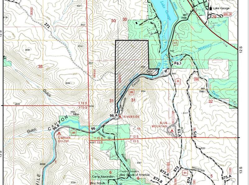
38.93435, -105.40736 Google Map · Climbing Area Map |
|
| Page Views: | 60,237 total · 202/month | |
| Shared By: | Julian Smith on Sep 24, 2001 | |
| Admins: | Leo Paik, John McNamee, Frances Fierst, Monty, Monomaniac, Tyler KC |
 Access Issue: Seasonal Raptor Closures January 1- July 31st, 2016-2021
Details
Access Issue: Seasonal Raptor Closures January 1- July 31st, 2016-2021
Details
Seasonal Closures in effect January 1-July 31st, 2016-2021.
For details visit:
fs.usda.gov/Internet/FSE_DO…
Maps:
fs.usda.gov/Internet/FSE_DO…
fs.usda.gov/Internet/FSE_DO…
Contact phone number: (719) 553-1400.
Description

"Turret Dome is the largest rock in Elevenmile and offers an excellent selection of moderate slab routes. The south face has routes up to three pitches long with runouts in some places. The west face is shorter and offers steeper routes." Bob D'Antonio (taken from his Elevenmile Canyon guidebook)...this says it all, "Outstanding multi-pitch rock with fewer [crowds] on it."
Getting There
Turret Dome is located 4.3 miles up the canyon on the right. Park at Elevenmile picnic area, cross the bridge, and head upstream. You can't miss it. For south and west face routes, approach high over a short slab to avoid a deadend into the creek. This will take you directly into the start of Schooldaze.
From the summit, work north, and downclimb to a saddle. Descend east to the picnic area.
Per Jon Banks: the descent from the summit has changed since the last comment. Now you can either rappel to the north from a fixed rope slung around a boulder near the summit or downclimb to the lower ledge (Class 4). These will bring you to a hard to spot boulder that is slung and has rap rings where you can do a short rappel to a lower ledge (if you downclimbed this section, it would be 5th Class). Walk off from here, then walk downhill to the east towards the picnic area.
Per jim meh: a much easier descent with rap rings on bolts was installed in 2024. At the summit, enjoy the views, then scramble along the ridge toward the west. You'll hop down onto a huge ledge protected by an overhanging boulder with lots of shade. There are rap rings bolted on the ground here. Rap off to the west. You'll touch down on an even bigger ledge here. Clean up, and head toward the gully to the north. There is no more dealing with sketchy slings around dead trees.
Classic Climbing Routes at Turret Dome
Weather Averages
|
High
|
Low
|
|
Precip
|
Days w Precip
|
| J | F | M | A | M | J | J | A | S | O | N | D |
| J | F | M | A | M | J | J | A | S | O | N | D |
Photos


All Photos Within Turret Dome
Most Popular · Newest · RandomMore About Turret Dome
Printer-FriendlyWhat's New


16 Comments