
 Continue with onX Maps
 Sign in with Facebook


Upper Blair Climbing
| Elevation: | 8,276 ft | 2,523 m |
| GPS: |
41.19595, -105.38529 Google Map · Climbing Area Map |
|
| Page Views: | 129,899 total · 452/month | |
| Shared By: | Brian Milhaupt on May 5, 2002 · Updates | |
| Admins: | Leo Paik, John McNamee, Frances Fierst, Aeon Aki, Mike Snyder, Taylor Spiegelberg, Jake Dickerson |
 Access Issue: Bad Bolt Submission Form & USFS press releases
Details
Access Issue: Bad Bolt Submission Form & USFS press releases
Details
See more USFS updates and press releases here:
fs.usda.gov/detail/mbr/news….
Description

The Upper Blair area of Vedauwoo offers many nice lines on a small band of tightly knit rock formations. A lot of the routes here face north, offering shade all, or part of the day. The lines are easy to find, and most are quite descript. The area is easy to navigate thanks to excellent topos, pictures, and descriptions in the "Heel and Toe: The Climbs of Greater Vedauwoo" guide. Another nice quality of this area is the lack of boulder fields at the base of the rocks, making canine access a breeze. Don't forget to check out Spectreman, the area classic.
Per Skip Harper: Upper Blair is literally bursting with high quality climbs - if you know where to find them. When I first started trying to make sense out of it (mid-eighties), I was blown away by the unruly disorganization of the place. One look at the 'Upper Blair topo' indicates just how crazy it is. I knew there were some great climbs 'up in here' and a few talented climbers were 'quietly at work', but there was no truly definitive material available. Using a combination of USGS Topos, an early aerial photo, mental notes from prior conversations, and a brief tour with one of the 'old guard' from Laramie who had summited some of the formations, I set out to 'decode' the place mostly devoid of trails and well-known landmarks. Yes, many knew where the '8 Ball' and 'John's Tower' were (they are hard to miss), but how about 'South Corner', 'Medium Cool' or 'Little Creatures'? No answers! Then Scarpelli's opus 'The Cracksmen' appeared ('87). Here was a compilation of detailed, hand-drawn 'route topos' of lines put up in Blair until that time. So if I could find the route - it would confirm the formation. The incomplete results ended up in "Heel and Toe" ('94); however, it also became apparent there was still lots of virgin territory to be explored.
Despite what is stated elsewhere, nearly 1/3 of the climbs in Upper Blair were put in during the nineties, an effort that continued to a lesser degree after 2000. Even today, with high resolution satellite information, GPS and new guidebooks, there are some climbs that continue to defy one's ability to find them. Perhaps the fabled 'Spectreman' is one of the most sought after climbs located here, yet there are many other climbs of (nearly) similar quality. There are thin fingers to hard offwidth in one climb (Ultraviolets), lengthy offwidths (SS Maywood), fun yet challenging climbs (Baobab Tree), big roofs (Roofinit), finger cracks that will really push you (What the French Girl Said), fine bolted routes (Easter Island), mixed climbs (trad+bolts = Disappearing Act) and other interesting concoctions (Inebriation Confabulation). No matter what your comfort level is, you will find adventures here that will keep you coming back again and again.
Getting There
From the I-80 exit drive west on the FR 705. This dirt road parallels the big skid on it's south side for 1.5 miles eventually going north underneath. Follow this road into the national forest and past the Lower Blair parking. The road curves and rises. Turn right onto FR 705A, and again onto FR705AF. Note the 8ball as you approach. Park at the end. Alternatively one can approach from the Lower Blair parking, or at a cattleguard uphill from Lower Blair with a trail on the south side of the barbed wire fence.
Per cstebbins024: from the I-80 exit 329, take Lincoln Hwy (the highway parallel to I-80) northwest watching for a right turn that goes underneath the interstate. This is FR 705. Follow this road into the national forest and past the Lower Blair parking. The road curves and rises. Turn right onto FR 707. After a short distance, either park at a less obvious road (now closed) just past a cattle guard or continue a little more and park near another barricade on FR 707.A, a more obvious road (also permanently closed). Note the 8 Ball as you approach. Alternatively one can approach from the Lower Blair parking, or at a cattleguard uphill from Lower Blair with a trail on the south side of the barbed wire fence.
Per Skip Harper: the topo was drawn as a basic guide to the formations and locator for some of the more well known climbs. Using this and one or more of the existing guidebooks, you can zero in on your chosen destination.
Per Kurtz: as of May 2021, you can drive to the end of the yellow line (near The Eight Ball). The unmarked fork that goes off the right side of this pic:
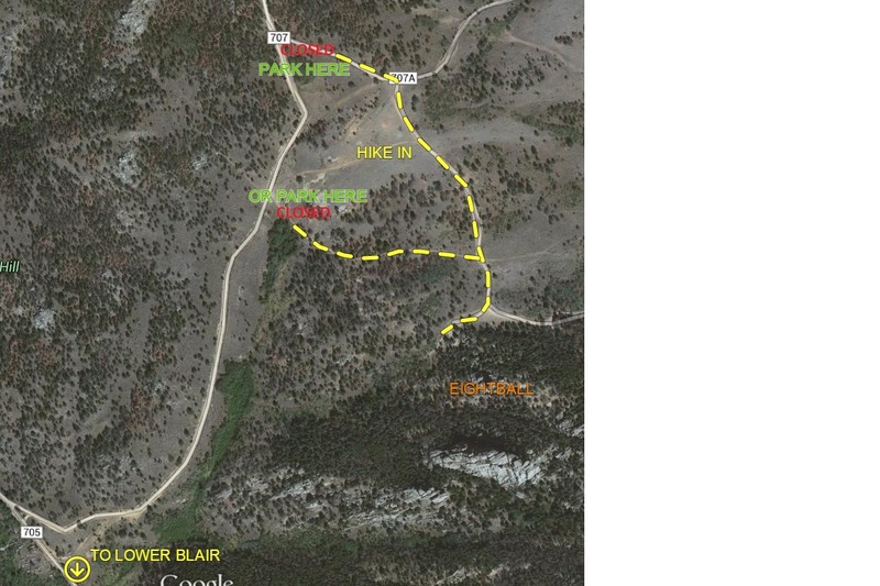
leads to a parking/camping area that is the closest parking to Spectreman.
Classic Climbing Routes at Upper Blair


Weather Averages
|
High
|
Low
|
|
Precip
|
Days w Precip
|
| J | F | M | A | M | J | J | A | S | O | N | D |
| J | F | M | A | M | J | J | A | S | O | N | D |
Photos


All Photos Within Upper Blair
Most Popular · Newest · RandomMore About Upper Blair
Printer-FriendlyWhat's New
Guidebooks (2)


4 Comments