| Elevation: | 3,621 ft | 1,104 m |
| GPS: |
33.17393, -110.78162 Google Map · Climbing Area Map |
|
| Page Views: | 369,555 total · 1,597/month | |
| Shared By: | Hendrixson on Feb 28, 2006 · Updates | |
| Admins: | Greg Opland, Brian Boyd, JJ Schlick, Kemper Brightman, Luke Bertelsen |
 Access Issue:
 - Portions of the approach and cliffs of this area are on private land.

Description

Please consider supporting the Access Fund's Homestead Campaign.
Getting There

To obtain directions on a map download this KMZ file, which can be viewed with Google Earth.
The Homestead is between Globe and Winkelman on Arizona State Highway 77. From Winkelman take State Highway 77 north for 14.8 miles. At mile marker 153 slow down and look for the passing lane to end and the road to head slightly downhill. Immediately before the guardrail turn right and drive down a short hill to a gate. This gate is marked with a white sign that reads "Close Gate Behind You" in red letters. The turn off is at 33.144692, -110.797102, before Dripping Spring Road.
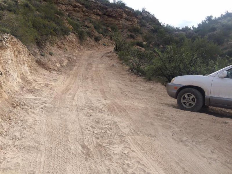
While the road was seriously improved by the Access Fund in March of 2016, a 4WD vehicle with high clearance is still recommended. To illustrate this point, a Honda CRV became stuck within hours of the road upgrades. If you lack an off-road vehicle make an immediate left to park. Please ensure that you are not blocking the road or access to ranch equipment. From here hike up the road (30-40 mins) to the upper Access Fund camping area.
If you are fortunate enough to have an off-road capable vehicle, continue down the road. The drive will ease after the first uphill crux section. Please drive in a lower gear, avoid spinning your tires, and maintain a reasonable speed to keep the road in good condition for everyone.
There are two Access Fund parking/camping areas as of March 2021. The upper parking sits on the ridge and the lower parking is down in the canyon. There is a pit toilet, marked by a small wooden "privy" sign and cairns about 10-20 ft down the road from the Homestead kiosk by the upper parking area. If parking at the upper parking area, the trailhead starts at the Homestead kiosk and goes 0.4 mile to the other side of the dirt road. If parking in the lower area, continue on the road, passing through both sets of gates (close them after you pass) and park after the second gate and the main trailhead.
Walk the road to the beginning of the trail that will take you to the crags. At the fork turn left/uphill to reach Finland Terrace, Tufa City, and Marley Wall. Continue straight/downhill to reach the other walls. Slate Nation and Mouse Wall are accessed from either trail.
Please camp only in the Access Fund campgrounds, pack out all waste and do not make campfires on windy days. Do not camp between the gates as this is private property. Close all gates. Do not jeopardize future access.
Guides
- John Hinrichsen created a supplement to Louie Anderson's PDF. It combined with Mountain Project is the best beta. The topos are available on Mountain Project and the PDF can be here.
- Louie Anderson published a PDF in 2007. This guide was the best reference for a number of years. It is high quality but is now missing many routes.
- The Homestead by Marty Karabin is a foldout pocket guide. This topo tends to be available at the Arizona Hiking Shack, Summit Hut, and REI for $5. Written in 2007 this guide is grossly out-of-date and not recommended.
- The Homestead: Arizona Limestone. This out-of-date guide does not list a date or author. It is presently available here.
Classic Climbing Routes at The Homestead
Weather Averages
|
High
|
Low
|
|
Precip
|
Days w Precip
|
| J | F | M | A | M | J | J | A | S | O | N | D |
| J | F | M | A | M | J | J | A | S | O | N | D |
All Photos Within The Homestead
Most Popular · Newest · RandomMore About The Homestead
Printer-FriendlyWhat's New
Guidebooks (6)

 Continue with onX Maps
 Sign in with Facebook


109 Comments