
 Continue with onX Maps
 Sign in with Facebook


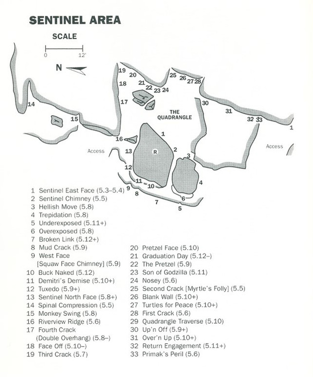
Sentinel Rock Climbing
Routes in A: Sentinel
|
|
A: Sentinel | 4410 T 5.9 5c 17 VI 17 HVS 5a |


|
Blank Wall TR 5.11 6c+ 23 VIII- 23 E4 5c |
|
|
Broken Link T 5.12+ 7c 28 IX 27 E6 6b |
|
|
Buck Naked T 5.12 7b+ 27 VIII+ 26 E6 6b |
|
|
Decapitator T,TR 5.6 4c 14 V 12 S 4b |

|
Demitri's Demise T 5.10+ 6b+ 21 VII+ 20 E3 5b |
|
|
Double Overhang aka Fourth Crack T,TR 5.8 5b 16 VI- 15 HVS 4c |
|
|
Face Off TR 5.10- 6a 18 VI+ 18 E1 5a |
|
|
First Crack T,TR 5.7 5a 15 V+ 13 MVS 4b |
|
|
Graduation Day T,TR 5.12- 7a+ 25 VIII+ 25 E5 6a |
|
|
Knob Off TR 5.10 6b 20 VII- 19 E2 5b |
|
|
Monkey Swing T,TR 5.8 5b 16 VI- 15 HVS 4c |
|
|
Mud Crack T 5.9 5c 17 VI 17 HVS 5a |
|
|
Next To Nothing 12.a TR 5.12a 7a+ 25 VIII+ 25 E5 6a PG13 |
|
|
Nosey T,TR 5.7 5a 15 V+ 13 MVS 4b |
|
|
Over and Up TR 5.11 6c+ 23 VIII- 23 E4 5c |
|
|
Pretzel TR 5.9 5c 17 VI 17 HVS 5a |
|
|
Pretzel Face TR 5.10 6b 20 VII- 19 E2 5b |
|
|
Primak's Peril T,TR 5.6 4c 14 V 12 S 4b |
|
|
Quadrangle Traverse T,TR 5.10 6b 20 VII- 19 E2 5b |
|
|
Return Engagement TR 5.11 6c+ 23 VIII- 23 E4 5c PG13 |
|
|
Riverview Ridge T,TR 5.6 4c 14 V 12 S 4b |
|
|
Second Crack aka Myrtle's Folly T,TR 5.7 5a 15 V+ 13 MVS 4b |
|
|
Sentinel Chimney T,TR 5.5 4b 13 IV+ 11 MS 4a |
|
|
Sentinel East Face T,TR 5.4 4a 12 IV 10 VD 3c |
|
|
Sentinel North Face TR 5.9- 5c 17 VI 16 HVS 4c |
|
|
Son of Godzilla T,TR 5.11 6c+ 23 VIII- 23 E4 5c |
|
|
Spinal Compression T,TR 5.5 4b 13 IV+ 11 MS 4a |
|
|
Third Crack TR 5.7+ 5a 15 V+ 13 MVS 4b |
|
|
Turtles for Peace T,TR 5.10+ 6b+ 21 VII+ 20 E3 5b |
|
|
Tuxedo T 5.9+ 5c 17 VI 17 E1 5a |
|
|
Up and Off TR 5.9 5c 17 VI 17 HVS 5a |
| Unsorted Routes: | |
Order Wrong?
Sort Routes
Use onX Backcountry to explore the terrain in 3D, view recent satellite imagery, and more.
Now available in onX Backcountry Mobile apps! For more information see this post.
| Elevation: | 633 ft | 193 m |
| GPS: |
42.12547, -90.15715 Google Map · Climbing Area Map |
|
| Page Views: | 29,524 total · 295/month | |
| Shared By: | Dave Hug on Dec 5, 2017 · Updates | |
| Admins: | Dave Hug, Kevin Sierzega, Aaron Mc |
Classic Climbing Routes at Sentinel
Mountain Project's determination of the classic, most popular, highest rated climbing routes in this area.
Weather Averages
|
High
|
Low
|
|
Precip
|
Days w Precip
|
Prime Climbing Season
| J | F | M | A | M | J | J | A | S | O | N | D |
| J | F | M | A | M | J | J | A | S | O | N | D |
Photos


All Photos Within Sentinel
Most Popular · Newest · RandomMore About Sentinel
Printer-FriendlyWhat's New


0 Comments