
 Continue with onX Maps
 Sign in with Facebook


Routes in Floyd Hill Saddleback Mt.

|
Across the Millennium V1+ 5 |
|
|
Captain Falcon V6- 7A |

|
Cliff Side Left V4-5 6B+ |
|
|
Cliff Side Right V1 5 |
|
|
Exodus V9 7C |
|
|
Exodus Low V10 7C+ |
|
|
Falcon Punch V5- 6C |
|
|
Keeper Left V6- 7A |
|
|
Keeper Right V5-6 6C+ |
|
|
Mini-Millennium Falcon V4 6B |
|
|
Miracle Block - Left-to-Right Traverse V1-2 5 |
|
|
Mirror Tan V2+ 5+ |
|
|
PC Blue V3-4 6A+ |
|
|
PC Chi V6- 7A |
|
|
PC Green V2 5+ |
|
|
PC Orange V3 6A |
|
|
PC Paryl V6-7 7A+ |
|
|
PC Sub Red V3 6A |
|
|
PC Super Violet V5 6C |
|
|
PC The Black Prism V4- 6B |
|
|
PC White V4 6B |
|
|
PC Yellow V4-5 6B+ |
|
|
Under the Millennium Falcon V8-9 7B+ |
|
|
Weaver's Demise V5 6C |
|
|
Weaver's Traverse V5 6C |
|
|
Weaver's Web V5 6C |
|
|
Whispering Barrows V6 7A |
|
|
Whispering Cave V7 7A+ |
|
|
Whispering Glade V6 7A |
|
|
Whispering Hills V5-6 6C+ |
|
|
Whispering Mantel V4 6B |
|
|
Whispering Mountain Left V7-8 7B |
|
|
Whispering Mountain Right V3+ 6A+ |
|
|
Whispering Needles V6- 7A |
Order Wrong?
Sort Routes
| Type: | Boulder, 12 ft (4 m) |
| GPS: | 39.70685, -105.42691 |
| FA: | Invinca Sends |
| Page Views: | 60 total · 7/month |
| Shared By: | Invinca Sends on Jun 21, 2025 |
| Admins: | Leo Paik, John McNamee, Frances Fierst, Monty, Monomaniac, Tyler KC |
Your To-Do List:
Add To-Do ·
Your Star Rating:


Use onX Backcountry to explore the terrain in 3D, view recent satellite imagery, and more.
Now available in onX Backcountry Mobile apps! For more information see this post.
 Access Issue: Seasonal Raptor Closures
Details
Access Issue: Seasonal Raptor Closures
Details
Please be aware of the annual raptor seasonal closures!
Raptor Closures Effective February 1-July 31
Visit: jeffco.us/open-space/news/2…
Tunnel 1 closure
For more details visit: jeffco.us/open-space/alerts…

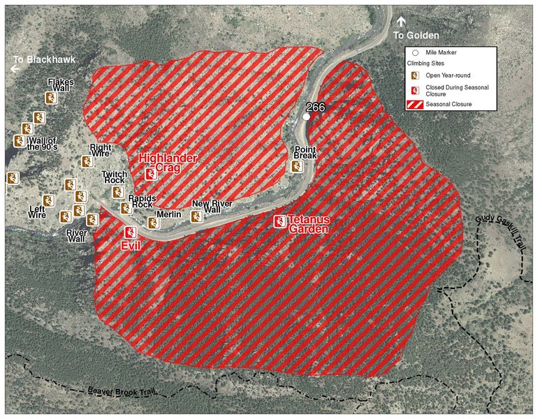
The two areas Jefferson County Open Space intends to close in Clear Creek Canyon, shown on the attached maps, encompass the active eagle nests. If the Clear Creek eagles continue to nest in the active nests, these areas will remain closed from February 1 through July 31. If the eagles choose different nesting sites, the closures will be adjusted accordingly to protect those eagles during their breeding season.
Currently, rock climbing areas that fall inside of the seasonal raptor closures include:
Blonde Formation
Bumbling Stock
Evil Area
Ghost Crag
Highlander
Skinny Legs
Stumbling Block
Tetanus Garden
Fault Caves
Raptor Closures Effective February 1-July 31
Visit: jeffco.us/open-space/news/2…
Tunnel 1 closure
For more details visit: jeffco.us/open-space/alerts…
The two areas Jefferson County Open Space intends to close in Clear Creek Canyon, shown on the attached maps, encompass the active eagle nests. If the Clear Creek eagles continue to nest in the active nests, these areas will remain closed from February 1 through July 31. If the eagles choose different nesting sites, the closures will be adjusted accordingly to protect those eagles during their breeding season.
Currently, rock climbing areas that fall inside of the seasonal raptor closures include:
Blonde Formation
Bumbling Stock
Evil Area
Ghost Crag
Highlander
Skinny Legs
Stumbling Block
Tetanus Garden
Fault Caves
Access Issue: Accessed via a narrow single dirt road - Beaver Brook Canyon Road - this is a very sensitive area!
Details
Use a 15 mph road: accessed via a narrow dirt road through a residential neighborhood. Uphill drivers yield to downhill drivers.
Per Allentg: please be extra careful to avoid conflicts with the local residents due to the twisty road, lack of parking, and the boulder being so close to the road. Consider climbing elsewhere! There was enough concern to request deleting this subarea.
Per Allentg: please be extra careful to avoid conflicts with the local residents due to the twisty road, lack of parking, and the boulder being so close to the road. Consider climbing elsewhere! There was enough concern to request deleting this subarea.
Description

Start with your right hand on a decent bump around the arete and your left hand on a bad crimp. Bump into an okay left hand sidepull followed by a good right hand hold. Then go up, and finish with an easy topout.
Location
The problem is around here (GPS coordinates): 39.704425, -105.438832.
The parking is at GPS coordinates: 39.707994, -105.437033.
From the lot, walk up Pat Creek Rd., keep left, and you'll find the entrance gate to the area. From the gate, it's about 2 minutes up the trail, and you can see the climb up the hill on the left through the trees.


1 Comment