
 Continue with onX Maps
 Sign in with Facebook


Iron Buttress Rock Climbing
Routes in Iron Buttress


|
Chocolate Bandit S 5.10b 6a+ 19 VII- 19 E2 5b |
|
|
Good Time To Be Pretty S 5.12a 7a+ 25 VIII+ 25 E5 6a |
|
|
Iron Maiden S 5.12b 7b 26 VIII+ 26 E5 6b |
|
|
Irony Man S 5.11a 6c 22 VII+ 22 E3 5c |
| Elevation: | 6,800 ft | 2,073 m |
| GPS: |
39.74006, -105.33914 Google Map · Climbing Area Map |
|
| Page Views: | 5,570 total · 47/month | |
| Shared By: | Monomaniac on Mar 10, 2016 | |
| Admins: | Leo Paik, John McNamee, Frances Fierst, Monty, Monomaniac, Tyler KC |
 Access Issue: Seasonal Raptor Closures
Details
Access Issue: Seasonal Raptor Closures
Details
Raptor Closures Effective February 1-July 31
Visit: jeffco.us/open-space/news/2…
Tunnel 1 closure
For more details visit: jeffco.us/open-space/alerts…

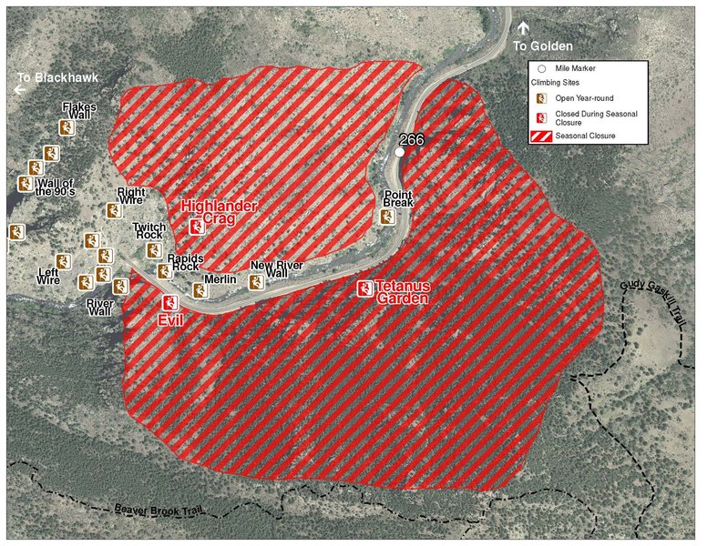
The two areas Jefferson County Open Space intends to close in Clear Creek Canyon, shown on the attached maps, encompass the active eagle nests. If the Clear Creek eagles continue to nest in the active nests, these areas will remain closed from February 1 through July 31. If the eagles choose different nesting sites, the closures will be adjusted accordingly to protect those eagles during their breeding season.
Currently, rock climbing areas that fall inside of the seasonal raptor closures include:
Blonde Formation
Bumbling Stock
Evil Area
Ghost Crag
Highlander
Skinny Legs
Stumbling Block
Tetanus Garden
Fault Caves
Description

A remarkable shield of iron-hued stone looms sentinel-like above the eastern threshold of Clear Creek’s central narrows. This west-facing panel of stone is every bit as good as it looks, offering brilliant climbing on crisp edges and intriguing angular features. The stone is a bit unusual—perhaps even unique—for the canyon, with a rich chocolate-colored patina of rough texture that is incredibly enjoyable to climb. Unfortunately the wall is typically short, and the season is likewise brief. A mandatory river crossing (currently) rules out summer, when this side of the canyon is in high demand. Conversely, winter snow on the north-facing approach would likely make this crag difficult to reach near the winter solstice. Still, when river and snow conditions are right, intrepid climbers will find enough here for a great day of climbing in a spectacular, secluded setting.
Routes R --> L:
1. Chocolate Bandit, 10-, 1p, 5B to 2BA, 40’.
2. Good Time To Be Pretty, 12-, 1p, 5B to 2BA, 40’.
3. Iron Maiden, 12, 1p, 4B to 2BA, 35’.
4. Irony Man, 11-, 1p, 7B to 2BA, 50’.
Getting There
Scout’s honor, the approach really isn’t as bad as it looks, with only an 8-minute, bushwhack-free hike, once you are across the river. Of course, crossing the river is not trivial. The best place to cross seems to be a few feet upstream of a freshly (still green) fallen pine tree that leans horizontally across the river, where a cheap pair of thigh-high waders will keep you dry in low water. Water levels are typically lowest from late September through late March (though conditions vary, check here for current Clear Creek flow rates, and see a summary of historic annual flow rates below:

See the approach topo for details. Park at the large pullout on the south side of the canyon just below the Sex Cave (this is a bit upstream from the crag). Once across the river, head back UPSTREAM to the first talus field. Climb this talus field to its top, then follow a cairned path up and right, under short cliffs, for 30-40 feet. Switchback left to the ledge system atop the first cliffs (and below another set of cliffs). Make an exposed step across a gully to gain another talus field. Traverse the bottom of the talus field, then head up along its left side for ~50’, exiting left at cairns. Switchback straight up the next narrow, wooded gully, heading east, passing several cairns. The gully broadens and ends at a ridge. Drop down the other side, at a large cairn, traversing the hillside for a few paces before dropping down 20’ to pass just behind a large pine tree. Climb back up along a broad ledge, passing a large boulder on your right, and then continue along the ledge, behind several pine trees, to another short talus field. Cross the talus field to reach the south end of the crag.
Classic Climbing Routes at Iron Buttress
Weather Averages
|
High
|
Low
|
|
Precip
|
Days w Precip
|
| J | F | M | A | M | J | J | A | S | O | N | D |
| J | F | M | A | M | J | J | A | S | O | N | D |
Photos


All Photos Within Iron Buttress
Most Popular · Newest · RandomMore About Iron Buttress
Printer-FriendlyWhat's New
Guidebooks (15)


3 Comments