|
|
Kephas Petros
·
Apr 5, 2018
·
St. Joseph, WI
· Joined Jan 2016
· Points: 528
Hey Y'all!
So I had an idea that I want to throw out there and see if people have some input as well as feedback.
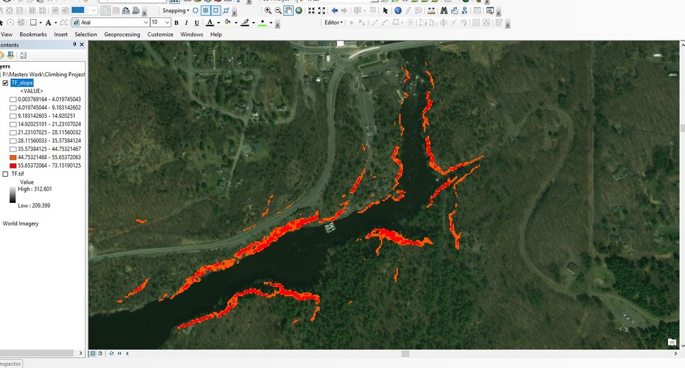
My idea is to use a geographic information system (GIS) and digital elevation model (DEM) to identify vertical rock in remote areas. This could be beneficial I think in finding new climbing areas in remote areas before even going there and could potentially help with logistics. I've been working with a DEM that was derived from a point cloud and focused on a known climbing area in Minnesota (Taylor's Falls, MN) to see if it's possible. So far it's pretty straight forward as I applied a 'slope' function (a spatial analyst tool) to the data set to identify the slope in degrees. This allows me to look for areas that have rapid changes in elevation (what you might expect for a cliff or any vertical structures). I then changed a few settings to set some thresholds that I won't get into on here. Essentially I made it so that the only thing being highlighted would be vertical faces and slab. A final product so far is shown in the picture I provided. Red indicates areas with vertical faces and orange would be your slab. I know this climbing area relatively well and I have to say it does indicate really well where the actually vertical walls that we climb here are.
Now that I have this done I am working on selecting only areas where the overall change in height is taken into account. This would let me select walls that are above say 20 feet but below maybe 120 feet to identify potential top rope areas. I could do the same for different ranges (120 feet and up for example) to identify potential multi pitch routes. Then maybe take everything under 20 feet and this could be for potential bouldering areas.
Let me know what y'all think of this, as I would love some feed back. If there are any ArcGIS (or QGIS) users who have some other ideas to throw out there, as well as anyone who may have access to a DEM of an area they would like looked at to try this out for other areas. I'm going to try working on areas in Washington, probably the cascades area, as Washington does have open access to their DEM.
Thanks everyone in advance!

|
|
|
Slogger
·
Apr 5, 2018
·
Anchorage, AK
· Joined Mar 2015
· Points: 80
What resolution DEM are you using?
|
|
|
Cole T
·
Apr 5, 2018
·
Cincinnati, OH
· Joined May 2012
· Points: 496
You could test this out in the red river gorge. I have played around with the dems their as well. What quality is the DEM? Also what angle are you using to identify walls potentially?
http://kgs.uky.edu/kgsmap/KGSGeoPortal/KGSGeoPortal.asp
biggest difficulty I would see is the ability of the computer to handle a large area when scouring for new potential and large high quality DEMs
|
|
|
Nathan Hui
·
Apr 5, 2018
·
San Diego, CA
· Joined Feb 2016
· Points: 0
Keep in mind that typically DEM from satellite data has spatial resolution in the several 10s of cm if not multiple meters, and aerial footage has spatial resolution in the 10s of cm. I suspect you might get a lot of areas that have vertical or near vertical faces, but little to no climbable lines. I think this would be more useful from a logistics point of view, but not so much from an exploration point of view for searching for climbable areas.
I would double check your method on known climbing areas, just to see how well your method picks up known climbing walls. That would give you a really good indicator as to how reliable your current method is.
Looking at DEMs from aerial LIDAR might be more interesting, but that data may be hard to come by.
|
|
|
Cole T
·
Apr 5, 2018
·
Cincinnati, OH
· Joined May 2012
· Points: 496
Kentucky has free statewide LIDAR that DEMs could be pulled from
|
|
|
DR
·
Apr 5, 2018
·
Unknown Hometown
· Joined May 2014
· Points: 998
|
|
|
Kephas Petros
·
Apr 5, 2018
·
St. Joseph, WI
· Joined Jan 2016
· Points: 528
Thank you for that link Cole!
The DEM I have currently is 3 meter and it is derived from aerial LIDAR. Minnesota spent some money ('some' being relative) a few years back and so fortunately I was able to use the DEM derived from the point cloud.
Areas like the Cascades though, which is what I'd like to work on next since I'll be going out there in the Fall so I could do some accuracy assessment while I'm there, might be a little tougher since Washington does provide a state wide DEM openly but it's 10 meter. So that might cause a little problem and I might have to incorporate other layers.
For the computer capabilities, yes, agreed. I tried running the entire statewide MN DEM on my computer, which has decent processing power I'd say, and it crashed. So I focused on an area that I know and did this. I do have access at my university to higher power machines and was planning on doing a state wide run on multiple cores to quicken the processing.
And I should have said this before, I'm sure this has been done and I'm definitely not the first to try this, but I think it'd be fun to develop a method to follow that is specific to the climbing community needs.
|
|
|
Ancent
·
Apr 5, 2018
·
Reno, NV
· Joined Apr 2015
· Points: 34
EarthExplorer ( earthexplorer.usgs.gov/) is a good resource provided by the USGS for DEMs. Of course better resolution will give you better results, but if you have Lidar data, you are no longer really doing reconnaissance work because someone already knew enough to care to fly a plane in a focused area or run a drone. I am not saying Lidar-flown sites are bad; just that this would generally imply the area is either small or already somewhat known.
For truly unknown areas, you could do the following: do some manual quality control via Google Earth to see if there are any specific features that are better than others, such as aspect/orientation (i.e., northern "slopes" in the northern hemisphere may be better cliffs), geology (i.e., granite is better than shale), or elevation (i.e., some bench in a river system is holding its steepness better than another. Then, you could set up some weighting to your data. So your first cut slope map gives lots of target areas, and then these get weighted based on their orientation, geology, and elevation. Or something to that effect.
I would pick a large area with known cliffs or crags that are somewhat variably littered throughout the landscape--say the ADKs--and see how it works. You need to optimize the size vs quality. There is no use in doing this if it requires small analyses of several km by several km.... you want to throw in a large area and get some particular sites to focus on.
Lastly, you could use Caltopo to do the same thing with less control on your elevation model. https://caltopo.com/
Just click "Slope Angle Shading". This is a very commonly used tool for checking out new ski areas to evaluate the slope angle.
|
|
|
Michael Palmer
·
Apr 5, 2018
·
Scottsdale
· Joined Nov 2015
· Points: 56
There was some discussion of this before here.
I used spatial analyst toolbox to get the range of elevations in a 3x3 moving window on a 1m DEM. I was able to pick out the 'secret cliffs' pretty quickly.
|
|
|
Sandbagger Vance
·
Apr 5, 2018
·
Cincinnati, Ohio
· Joined May 2016
· Points: 0
Cole T wrote: Kentucky has free statewide LIDAR that DEMs could be pulled from Where? I have not been able to find LIDAR data for eastern kentucky.
|
|
|
Kephas Petros
·
Apr 5, 2018
·
St. Joseph, WI
· Joined Jan 2016
· Points: 528
Ancent wrote: EarthExplorer ( earthexplorer.usgs.gov/) is a good resource provided by the USGS for DEMs. Of course better resolution will give you better results, but if you have Lidar data, you are no longer really doing reconnaissance work because someone already knew enough to care to fly a plane in a focused area or run a drone. I am not saying Lidar-flown sites are bad; just that this would generally imply the area is either small or already somewhat known.
For truly unknown areas, you could do the following: do some manual quality control via Google Earth to see if there are any specific features that are better than others, such as aspect/orientation (i.e., northern "slopes" in the northern hemisphere may be better cliffs), geology (i.e., granite is better than shale), or elevation (i.e., some bench in a river system is holding its steepness better than another. Then, you could set up some weighting to your data. So your first cut slope map gives lots of target areas, and then these get weighted based on their orientation, geology, and elevation. Or something to that effect.
I would pick a large area with known cliffs or crags that are somewhat variably littered throughout the landscape--say the ADKs--and see how it works. You need to optimize the size vs quality. There is no use in doing this if it requires small analyses of several km by several km.... you want to throw in a large area and get some particular sites to focus on.
Lastly, you could use Caltopo to do the same thing with less control on your elevation model. https://caltopo.com/
Just click "Slope Angle Shading". This is a very commonly used tool for checking out new ski areas to evaluate the slope angle.
That's a really good idea! Are you ok if I give what you said a go for your weighting approach? Thank you very much for that. As for earthexplorer, that was in the back of my mind but I wasn't sure how great the DEM's might be, but I'll for sure look around on there. I was also thinking of potentially running what I can through Google Earth Engine, as I have some experience with that, but it might be helpful for running for the larger areas. But again I'd have to take into account the elevation models that are being used and how good they are.
|
|
|
Kephas Petros
·
Apr 5, 2018
·
St. Joseph, WI
· Joined Jan 2016
· Points: 528
Michael Palmer wrote: There was some discussion of this before here.
I used spatial analyst toolbox to get the range of elevations in a 3x3 moving window on a 1m DEM. I was able to pick out the 'secret cliffs' pretty quickly. Looks like y'all beat me to it haha, but this is great for input. I'll for sure be looking at this thread for some ideas.
|
|
|
Cole T
·
Apr 5, 2018
·
Cincinnati, OH
· Joined May 2012
· Points: 496
Sandbagger Vance wrote:Where? I have not been able to find LIDAR data for eastern kentucky. they finished the statewide coverage this January for Kentucky, should be findable on the kygis portal
|
|
|
Rick Carpenter
·
Apr 5, 2018
·
Marion, NC
· Joined Aug 2010
· Points: 1,315
Did this to find boulders/rock in AK & NC. Great way to pass time when bored.
|
|
|
ryanb
·
Apr 5, 2018
·
Unknown Hometown
· Joined Dec 2008
· Points: 85
I wrote a site (hillmap.com) that does slope analysis a few years ago. Originally it used a DEM web service that appears to have recently died, not it uses the caltopo slope layers which are excellent.
I've used it to scout/find crags/boulders in the cascades and Western Montana a lot. The big problems are there are lots of steep areas that aren't claimable cliffs (either choss or steep dirt) and there are lots of trees and dense forests that throw things off depending on the technology used. I've had the best success looking for rock formations manually in satellite photos, but I know there are a lots of boulders and small cliffs hidden in shady forests that will be hard to spot.
I've thought about doing some sort of basic image recognition approach (essentially just a more sophisticated version of the weights proposed above) but it doesn't take that much time to just look over a river drainage with reasonable road access and see what areas might be worth checking out.
There are several stories of LIDAR being used to spot ancient ruins in the jungles of the yucatan etc that lead one to believe it should easily be able to pick out crags and boulders. LIDAR coverage is expanding but mostly in flood plains and coastal areas.
|
|
|
Gilman Coryell
·
Apr 5, 2018
·
Mount Vernon, ME
· Joined Jun 2012
· Points: 65
I didn't see this mentioned above but Global Mapper has a pretty robust Lidar tool kit. If you can get the Lidar data, working directly with the point cloud seems like a good way to go.
|
|
|
Eli B
·
Apr 5, 2018
·
noco
· Joined Nov 2010
· Points: 6,067
I know a lot of the DEMs I find are in 30m x 30m resolution, which isn't particularly useful for boulders or small cliffs. Great idea overall.
|
|
|
Matt Hostetler
·
Apr 5, 2018
·
Unknown Hometown
· Joined May 2016
· Points: 141
ryanb wrote: I wrote a site (hillmap.com) that does slope analysis a few years ago. Originally it used a DEM web service that appears to have recently died, not it uses the caltopo slope layers which are excellent.
I've used it to scout/find crags/boulders in the cascades and Western Montana a lot. The big problems are there are lots of steep areas that aren't claimable cliffs (either choss or steep dirt) and there are lots of trees and dense forests that throw things off depending on the technology used. I've had the best success looking for rock formations manually in satellite photos, but I know there are a lots of boulders and small cliffs hidden in shady forests that will be hard to spot.
I've thought about doing some sort of basic image recognition approach (essentially just a more sophisticated version of the weights proposed above) but it doesn't take that much time to just look over a river drainage with reasonable road access and see what areas might be worth checking out.
There are several stories of LIDAR being used to spot ancient ruins in the jungles of the yucatan etc that lead one to believe it should easily be able to pick out crags and boulders. LIDAR coverage is expanding but mostly in flood plains and coastal areas. Very cool! What settings do you like to use to pick out crags?
|
|
|
z t
·
Apr 5, 2018
·
Spokane, WA
· Joined Dec 2011
· Points: 1,197
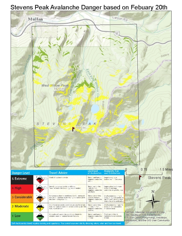
This doesn't contribute much to the OP's goal of searching for cliffs, but it's similar to a project I did in school.
We used the Idaho DEM to create slope, aspect, and elevation layers to make a visual representation of the avalanche advisory.
Obviously not the best way to navigate avy terrain, but I thought it could be useful in route planning.
|
|
|
Ryan Surface
·
Apr 5, 2018
·
Kansas City
· Joined May 2014
· Points: 438
I summed up my previous processes in this thread
https://www.mountainproject.com/forum/topic/112462728/using-gis-maps-to-find-roxx-a-guide
My next step will be using the Lidar .las data sets using some kind of focal operation to specifically extract the cliff faces. The only reason I haven't been doing this is lack of computing power, and I need to send a hard drive to my local GIS clearinghouse to upload all the .las for a given county (instead of downloading it all LOL)
30M DEM's have had their day. Next gen will be
L I D A R
|
|
|
Double J
·
Apr 5, 2018
·
Sandy, UT
· Joined Apr 2006
· Points: 4,284
Please do the western UP and then send me the map!
|

 Continue with onX Maps
 Sign in with Facebook