
 Continue with onX Maps
 Sign in with Facebook


Using GIS (maps) to find Roxx: A Guide


|
|
Community, |
|
|
Don't forget Lidar as an elevation source. It's likely to have better resolution than nationwide DEMs. Some of the state-wide projects have pretty great resolution as well. I think someone in KY was using Lidar to identify clifflines, especially overhanging ones, for a Master's project. |
|
|
Nice write up, I use ArcGIS and all sorts of aerial imagery as a civil engineer. It wasn't until I got into climbing that I realized that I was way better at reading topographic maps than any of my climbing buddies. |
|
|
I agree, Lidar derived DEM's are very nice, although in my study areas they never seem to have coverage. |
|
|
Sandbagger Vance wrote:Nice write up, I use ArcGIS and all sorts of aerial imagery as a civil engineer. It wasn't until I got into climbing that I realized that I was way better at reading topographic maps than any of my climbing buddies. If I could add anything it would be that older land surveys will sometimes note cliff line. For example here in Kentucky there are a lot of older surveys to find the best areas for oil wells and coal seams. These surveys will sometimes date back as far as the 1800's but may not the location of clifflines as it was kind of a big deal to traverse a cliff in the 1800's. A lot of these older maps are publicly available through local university GIS programs. Here in KY NKU is a great resource for this information. Beyond that if you are looking for boulders in an area with a lot of tree cover, power line easements will sometimes reveal areas where there are boulders.Are you referencing General Land Office surveys? Used primarily during the homestead act and westward expansion, they generally only walked the section lines, a 1 mile grid, but I do remember there being many field notes that were assocated with township level maps that could be neat to dig into. I developed an algorithm in undergrad to automatically georeference these GLO maps for the state of Kansas. |
|
|
I have a story based on this. I'm a student at Arkansas Tech, and we have access to programs such as ArcGIS. I had the same idea you had and downloaded the Arkansas Topo map from the Arkansas GIS office webpage. |
|
|
I got bored one day and wrote some code to pull elevations from google maps. I than built a color coded map based on height differences between the locations. I tested it at crags I had climbed at and it highlighted the areas where you climb pretty nicely. 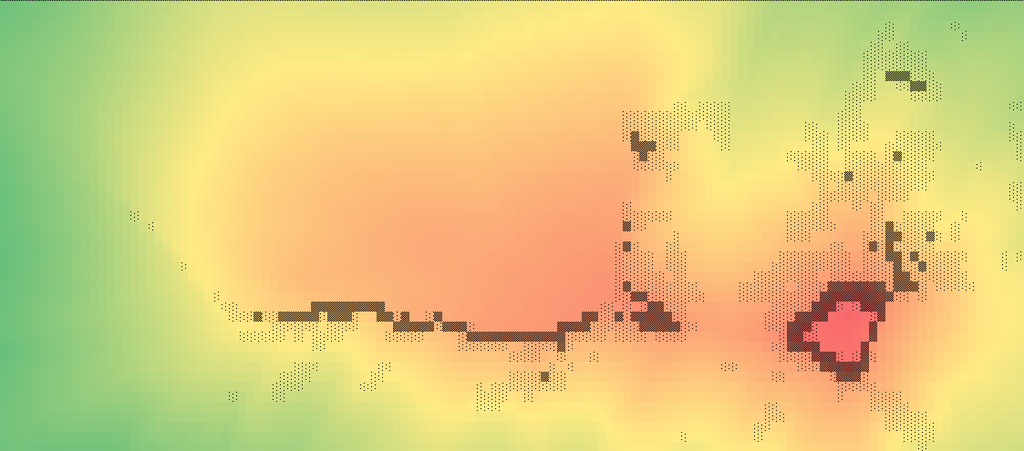 On this lower photo the light area kinda in the middle top is the image is a boulder field. The main cliff line is around 200-300ft. 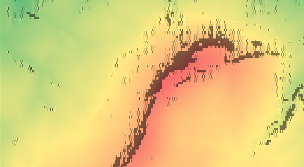 |

|
ViperScale wrote:I got bored one day and wrote some code to pull elevations from google maps. I than built a color coded map based on height differences between the locations. I tested it at crags I had climbed at and it highlighted the areas where you climb pretty nicely. I thought about just running it over large areas to try to find new possible cliffs to climb. Here are 2 samples. The color is just scale from the lowest to the highest elevation point and the black marks are based on difference in height compared to the points next to it. So the greater the distance between the 2 points the darker it gets. Points that are say under say 25ft will get no marks (forgot what the value I used when I made these it was a while ago. The wall for this area is around 50-120ft. The area on the bottom right is about 200ft but is off limits for climbing. On this lower photo the light area kinda in the middle top is the image is a boulder field. The main cliff line is around 200-300ft.This is awesome! Care to share more about this technique? |
|
|
Basically just set a max and min GPS location. The code than just loops through and pulls the elevation from google maps based on what the distance setting of how often you want to to check the next point. These values were output into a csv file. |
|
|
ViperScale wrote:Basically just set a max and min GPS location. The code than just loops through and pulls the elevation from google maps based on what the distance setting of how often you want to to check the next point. These values were output into a csv file. The csv file with elevations were than loaded into an excel spreadsheet and conditional formatting color scale was applied. I than added some additional conditional formatting to apply the black highlights on top of that to figure out where there was big differences between values next to each other. I than shrunk down the cell size so you could not see the text and it made a nice even square box and made a screenshot of it.So basically you are brute force converting point elevations to raster, it would be super handy to know the actual raster cell size that google is using, I'm betting in extremely rural areas it will still sometimes be NED 10M, but since google are the master data holders they probably have a lot of nice high resolution lidar data. |
|
|
Ryan, |
|
|
Sure everyone knows what this was taken from.   |
|
|
bump for more discussion |
|
|
Ryan I am considering doing my GIS project on this on Indiana. Mountain project only has 36 routes but with how hill it can get there, theres gotta be more What tools did you use? could you potentially post up the mdb file? |
|
|
Luke Nitcher wrote: Luke, I would start by obtaining a Digital Elevation Model (DEM) of your target area, convert this to slope, start identifying areas with significant slope. Look at other areas where there IS known climbing to use as training data. If your GIS class has not covered how to use the raster data model this might be too advanced of an exercise. |
|
|
Michael P wrote: That is pretty great if you have statewide 1m lidar coverage, however you may want to start with a coarser resolution DEM for your initial identification of steep areas, especially if you are attempting to do this on a state wide scale. |
|
|
http://gis.iu.edu/datasetInfo/statewide/in_2011.php I grab my lidar data from here if I'm working in Indiana. OGRIP has some pretty good info as well. Another good resource that I haven't had the chance to explore at work is http://libremap.org/ Seems like a promising repository, I have been meaning to use it to find some bouldering areas in KY, just haven't found the time. Plus my work computer craps out whenever I bring miles of topo into AutoCAD |
|
|
ViperScale wrote: Basically just set a max and min GPS location. The code than just loops through and pulls the elevation from google maps based on what the distance setting of how often you want to to check the next point. These values were output into a csv file. The csv file with elevations were than loaded into an excel spreadsheet and conditional formatting color scale was applied. I than added some additional conditional formatting to apply the black highlights on top of that to figure out where there was big differences between values next to each other. I than shrunk down the cell size so you could not see the text and it made a nice even square box and made a screenshot of it. That's pretty impressive, would you feel comfortable sharing the sourcecode? Or if I gave you some lat longs would you run the program in some areas of the Red? |

|
Justin Barrett wrote: Buuuut, I want to say that ArcGIS could be used to find new rock, just check who owns it I haven't done any GIS project for a few years, but when exploring new lands I would typically bring in an ownership layer that allowed me to choose land based on parameters (easily weed out privately, state, federal, Native American owned lands). Overlay that to whatever area you are searching through and you can avoid getting shot at :) Here is the file I used for Utah: https://gis.utah.gov/data/sgid-cadastre/land-ownership/ Played around with elevation models and ground surface types to identify possible climbing areas a number of times. No new development came out of it, but it made my hours in the GIS lab much more enjoyable. Really fun to see what others are using to discover new spots. |
|
|
It might be worth it to load in a layer of local geology with the units listed, that way when you get a result for a large elevation change or slope, you can see what unit it's in. A lot of time there's local information on the geologic units in your area so a quick search can give you some insight into rock quality. Source: (soon to be) geology graduate |
|
|
Sandbagger Vance wrote: Do you have the spatial analyst toolbox? You can calculate the range of elevations within a 3x3 (or whatever grid you want) window of cells. http://pro.arcgis.com/en/pro-app/tool-reference/spatial-analyst/focal-statistics.htm |


