
 Continue with onX Maps
 Sign in with Facebook


Slackline causes helicopter crash and 4 deaths


|
|
Mr Rogerswrote: "The line was flagged and had lights as the NOTAM filing clearly shows...... not sure to the degree those boxes were checked, but they were, at least a little." Can somebody explain how to attach lights to a slackline that would not interfere with a safety carabiner? |
|
|
Ti ck wrote:
|


|
Yurywrote: New Safety suggestion….while line is up  but seriously, seems a couple of big wind socks or flags flying from either side of center would be easy to implement during daylight hours. If I was using the line, I’d also consider having a VHF for Air frequencies like 121.5 MHz to communicate in an emergency when line is in use or about to be used. Edit to Mike below: I assume they are retrievable/extendable on a separate pull line along the main or installed on a permanent parallel line below the main. At least that’s how I’d do it with the flags/windsocks |
|
|
Yury wrote: Mr Rogers wrote: "The line was flagged and had lights as the NOTAM filing clearly shows...... not sure to the degree those boxes were checked, but they were, at least a little." Can somebody explain how to attach lights to a slackline that would not interfere with a safety carabiner? Ti ck wrote: I am sure most readers understood the significance of Yury's question, but for the few that didn't, to expand on it a bit, how do you attach lights without interfering with the sliding safety carabiner and also use lights that have a longevity and brightness to actually be useful. |
|
|
Mark Pilatewrote: Very clever! Thanks Mark. |
|
|
There will be changes to the chopper dynamic at Sedona, probably the slack lining too. Less of both, is my vote. A lot less. |
|
|
Not much to add to the discussion except that the nav map overlay that clearly shows all NOTAM activity seems like a valuable tool that may have prevented this accident. Blancolirio makes note of this and shows that the NOTAM for the highline was present before and after the accident. Can any of the pilots offer any insight about how this tool is used and if it is a common feature in modern aircraft? |
|
|
The NOTAM was filed only with an air strip nearest the slack line, which was very small and infrequently used. The NOTAM was not filed with the larger airport that the helicopter actually flew out of. The pilot most likely was unaware of the NOTAM. He likely only checked NOTAMs filed with the airport he was flying from. |
|
|
Daniel Shivelywrote: 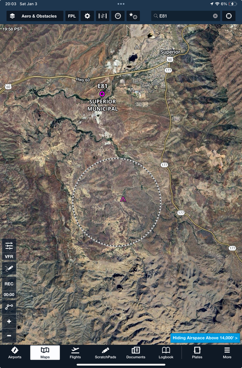 This is a screenshot from my iPad. I'm running Garmin Foreflight and turned on the NOTAM layer. I also have the satellite imagery shown (which I generally wouldn't use flying) to show how complex the terrain is where this slackline and pilot were. The NOTAM for the slackline is the black and white circle. A NOTAM is not a TFR - which appears as a red circle on Foreflight and immediately draws your attention; a NOTAM is informational; it isn't closed airspace. Foreflight, like Mountain Project, is common, but not all pilots use it all the time. The pilot would a) have to have and use Foreflight, b) have the NOTAM layer turned on, and c) notice that his/her flight path took them through the active NOTAM (and check to see what that NOTAM is...) It is not unreasonable to think many pilots might do this... but it is also not unreasonable for a pilot (especially one who is very experienced and flies in a particular area regularly) to not do this. The thing to remember is that most of us, when engaged in climbing or hiking or whatever, are moving very slowly and have tons of bandwidth to stop, observe, and see things. A 1 KM slackline might seem so obvious (especially if flagged and lighted) that you might wonder "how could someone possibly miss that???" But this pilot is probably flying at 60-100 KTS and is paying attention to a LOT of things: airspeed, attitude, altitude, instruments, radios, weather, the sound and feel of the helicopter, his three nieces next to him and in the backseat, the fact that he's getting married in a few hours... and he's scanning for birds and other aircraft and keeping track of possible places to set the helicopter down if there's an engine failure... He's single pilot so he's doing all that himself. Is he also looking at his iPad? The brain has limited capacity to handle all these demands and information and in doing so it becomes much harder to see something like this - especially since it undoubtedly wasn't there the last time (or any time) he flew in that canyon... in aviation this is called an expectation bias. Edit to add: I'm speculating. I do not know this pilot or what happened exactly. I do know he was hugely experienced and has been flying for longer than just about anyone on Mountain Project has been climbing and dedicated his life to helicopters much like many of us dedicate our lives to climbing. The NTSB report will be the thing to look for. Most of all I'm incredibly sad for him and his family and honestly it keeps me up at night thinking about how it could happen to me. |
|
|
Ti ck wrote: While I understand this and agree with this, helicopters flying through wilderness are probably a lot more disruptive to wildlife, natural ecologies, and humans seeking solitude and serenity. However, in this case, it's a terrible tragedy for everyone involved. Our annoyances seem petty in the face of such a terrible event. |
|
|
Yeah, helicopters are annoying as fuck. I'll be the first to say it. But they're pretty great when you break your ankle in the middle of nowhere... or are glad you have a cell signal thanks to a cell tower that was placed via helicopter for that matter. Also, if it's a Hollywood action movie and it doesn't have a helicopter, then it's not worth watching. |
|
|
OP, can you change the title of this thread to be more accurate as to the event? It is very misleading. |
|
|
Josh Janeswrote: Thanks for the info. I understand all of the factors that you described too. Maybe at some point Foreflight may consider making the NOTAM indicator a brighter color pattern or have an audible alarm that activates when in close proximity to a NOTAM. While not a perfect system that overlay seems to provide pertinent info that could help avoid accidents like this in the future. I have a friend who flies a tiny 1946 Taylorcraft. When he took me on a flight around the mountains near Bishop, he used a thigh mounted device that the screen looked very similar to your screenshot. Flying in close proximity to those mountains was wild and I can imagine not having much time to constantly look at a screen. Ps. I’m not trying to assign blame here, just interested in learning. |
|
|
Thanks for taking the time to break things down in simpler terms from a pilots perspective, Josh. As you know I’ve supervised some incredibly complex air shows and there is a lot going on, happening at a high rate of speed, so many things can go wrong. This is really an awful tragedy for everyone involved. I don’t think I ever worked with the pilot, but have certainly seen his aircraft on fires. My thoughts are with the families of the victims and I hope that the people who set up the line are getting the support they need, as well. |
|
|
This is absolutely horrific. I would think that if you are going to have a slack line set 600ft in the air that it would have to be marked with the same style and grade of lighting that they use on the big power lines. |
|
|
Josh Janeswrote: Since its not closed airspace, how do you determine if its safe to fly over? |
|
|
Josh Janeswrote: When I look up 33.1412, -111.0714 on caltopo or google maps, it gives me a location 11km south of what you are showing with that black and white circle. |
|
|
tom donnellywrote: The coordinate system used in NOTAMs is degrees/minutes/seconds - not decimal degrees. What you looked up (33.1412, -111.0714) is not the same as "331412N1110714W" as written in the NOTAM. Try looking up 33° 14' 12" N, 111° 07' 14" W and you'll see the location of the circle in Foreflight is correct. |
|
|
Josh Janeswrote: Hey Josh, I agree with all of that, but I'll say this: I've been an FAA Part107 remote certified pilot for 3 years now. Honestly, my Part107 is a joke compared to an actual fixed wing or PRH (helicopter rating). I can't pretend I know much, I fly drones for a living. Point is, even I know that NOTAMs need to be checked prior to takeoff. As you stated, the pilot clearly had a lot to focus on while flying, but if he read the NOTAMs prior to takeoff, he wouldn't have been flying in that canyon. To assume the pilot needs to be looking at NOTAMs on an iPad while flying through a canyon is ridiculous and negligent on the pilot's part. I find it difficult to give the pilot any excuse for not seeing the NOTAM before even entering the helicopter that day, and I'm certain the FAA would agree. Regardless, my heart is heavy for the pilot, passengers, as well as the slackliners who rigged the line. |
|
|
I'm not making excuses for the pilot and I don't know all the facts. I do not know if the pilot checked the NOTAMs or not. I'm saying I can see how this accident could have played out and my intention is simply to help climbers understand it from an aviation perspective - and also express my tremendous sympathy for the pilot, his family, and the slackliners. I also have my Part 107 cert. I won't call it a "joke" but it's not exactly difficult to get. I mean no offense, but it is no way in the same ballpark to actual flying in terms of complexity, risk management, pressure, etc. Personally, I think your statement that "...I find it difficult to give the pilot any excuse for not seeing the NOTAM before even entering the helicopter that day" sounds like the kind of thing a non-pilot would say, though it is correct to the letter of the law (the "FAA would agree" as you put it). As I previously said, I predict the NTSB will attribute the cause of this accident to failure of the pilot to check/read/observe the NOTAM - along with a list of contributing factors or secondary causes. Again, in looking at this I used the FAA NOTAM search tool and looked at every airport within a 30 NM radius of the slackline. As I previously mentioned, the only airport that returned the NOTAM was E81. You should take a look at E81 on satellite imagery. Would I have checked this airport's NOTAMs were I flying a scenic flight in the region? Maybe. Probably not. Hopefully I would have noticed it on Foreflight. You can also search a flight path/plan and get NOTAMs that way. Since I do not know this pilot's flight path/plan, I couldn't recreate such a search to see if this NOTAM would have been returned. |


