
 Continue with onX Maps
 Sign in with Facebook


Short term future of Needles climbing, the straight dope...


|
|
https://www.fs.usda.gov/recarea/sequoia/null/recarea/?recid=79802&actid=50 The online status is incorrect. The trail.is open, the camping is closed |
|
|
Dave Daly, texted me that the upper gate is open. Word on 190 is that the completion of the work there may extend for a couple more years (no shit). - ec |
|
|
Damage on 190 was pretty heavy in some places. Not just the road but the surrounding hillsides as well. These are from late May just east of Camp Nelson. 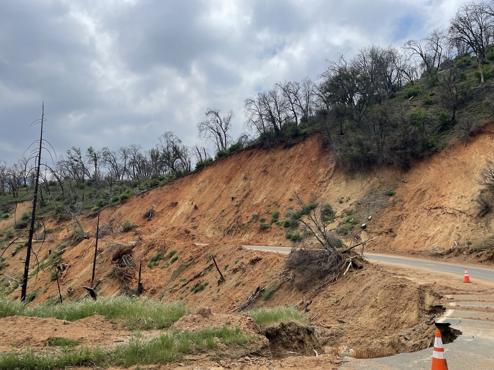 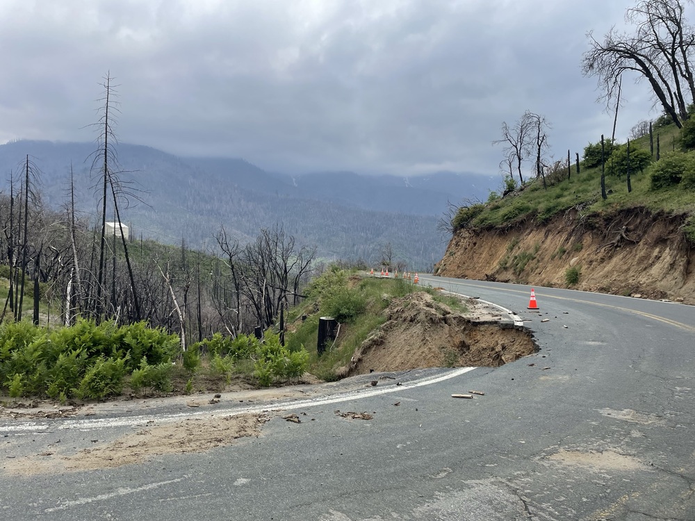 |
|
|
Heading north from Ponderosa, where is 190 closed? Quaking Aspen? |
|
|
Update for folks that may be looking for more explicit info: - 21S05 is not easily accessable from the north (CA-190 is blocked at some point north of 21S05) - 21S05 is easily accessible from the south (either from the W via CA Hot Springs or from the E via Kernville) ** 22S02 is *CLOSED* - check that your google maps route does *NOT* take you here, it will drop you at a closed gate (likely only an issue if you are coming from Kernville) ** Take M-90, CA-107, Great Western Divide HWY the whole time after it turns north off M-50 - 21S05 is easily driven all the way to the trailhead, no issues whatsoever - The great camping spot just uphill from the end of the road/TH is clearly marked as closed due to falling hazard - No signs at or about end of the road/TH being closed/prohibited to sleep in your car - The approach trail to the Magician Summit is in pretty good shape (no complaints, easy to follow) - The approach the Magician Summit to the Witch/Charlatan Notch is relatively well marked with cairns, easy to get to/from There were a few parties out there on Saturday, the place is awesome! Cheers, |
|
|
10/26/2023. I just spent a few days up in the area. Driving up past Johnsondale, going up from Kernville, I came across this sign: 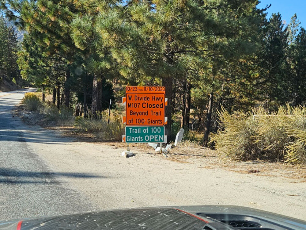 So, I turned north on the LLoyd Meadows Rd (22S82), and then up 22S02 - an excellent gravel road that is a short cut up to the Western Divide Highway, connecting well north of the 100 Giants. This road was open, and there was no indication of a closure when I arrived at the Western Divide Hwy (CA 190). Ahah, thought I, a way around the closed part. And I sped off northward toward Ponderosa. But, about a mile or two before Dome Rock there is a very permanent looking barricade. The road is indeed closed, and it appears that it will remain so through mid-November. Caltrans shows the 190 from Porterville as still closed, and now the road coming up from the south is closed, so getting to the upper Needles road is a no-go. Lloyd Meadows Rd (22S82) going up under the Needles and Voodoo Dome is open all the way up, and with the temps cooling, Voodoo Dome will be getting nice. |

|
Thanks for the updates, Kristian ! Made the drive from the south a few weeks back with a friend, just to go to dome rock... The road had some minor holes/issues i could see they might be addressing. Unless its related to more controlled burns / tree work. Hopefully there is a bit of season left from the top-entrance, after the 10th of Nov. ! |

|
Is the closure before or after Dome Rock? |
|
|
I guess that in the “New California” we have forgotten how to fix roads, open the forest, paint lines on roads or fix broken signs. It’s really sad. |
|
|
Juan Vargaswrote: The closure is before Dome Rock. I'd estimate by 2-3 miles. |
|
|
Earlier in October, that section was wide open. We came in from CA Hot Springs, gone to Dome and hiked out to the upper Needles, no problem - but had driven down to Kernville and back as well. I'm curious what that closure is about beyond the normal winter closure. Someone close to me that knows a road supervisor for Hwy 190 said that it may be 2 years before that will be open to the public. Currently, only permanent residents are allowed thru. - ec |
|
|
I was there climbing for 3 weeks in October and coincidentally left just days before that most recent closure went into effect. This is all purely speculative, but that section of the road was really haggard including a short stretch of 1 way traffic where it'd slumped a foot or so downhill in the outside lane. As we were leaving, it looked like they were getting ready to work on that section (heavy machinery, temporary bathrooms, water, piles of gravel, etc) so maybe the closure is related to doing road repairs on that length of highway? Even beyond that one section, the road was pretty pot holed and prone to rockfall from the road cuts above. Hopefully it's getting a facelift, but 2 years sounds like a long facelift... |
|
|
The roads were hit hard up there. They've had a crew along Hwy. 190 down canyon of Camp Nelson for many months, first clearing the road from the MANY landslides and then actually repairing washed out or sunken sections of the roadway. Unfortunately, Hwy. 190 is a pretty obscure road leading to a pretty small community, so while the attention has been consistent, it hasn't been high volume. I suspect it will take a while to fully reopen the road again. Fingers crossed that if we get another El Nino, as has been forecast, it doesn't trash the road even more. |
|
|
If anyone gets word of it opening back up… I’d love to hit up dome rock soon |
|
|
While we were there, many sections of pavement had literally burnt/melted from burning trees that had fallen onto it. The trees had been removed but the damage had been done. The pavement was coming apart at those points. |
|
|
Once it storms, all bets are off. Camping at the trailhead was not allowed. Uh, it’s not “north.” Camping along any other road spur was deemed ok, just not at Dome or the Needles trailhead |
|
|
Hope all that changes next year, regarding the Needles TH. |
|
|
Dave Dalywrote: Ring ring, any chance anyone has been out this spring to either dome or needles by either the low or high road this season already? I'm itching to get out there and noticed there hasn't been an update on this thread since last year. Fingers crossed. |
|
|
I was up in the area last week. Access to the Western Divide Hwy via Ducor/CA Hot Spring is closed. The gates are at Pine Flat from the west, and Johnsondale, coming from from Kernville. Also, Lloyd Meadows rd (lower rd to Voodoo Dome) is closed. Last Wed 5/1 afternoon: Lloyd Meadows Rd at Johnsondale: 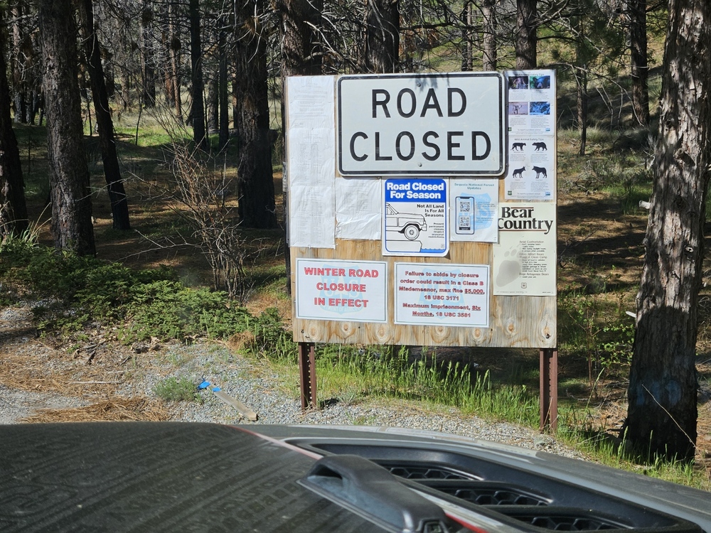 Parker pass rd over to CA Hot Springs at Johnsondale: 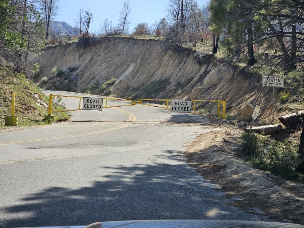 Hwy 190 from Porterville/Springville is ambiguous. Tulare County highway dept site says it is only open to locals beyond Camp Nelson, but a local told me yesterday that it is open to Ponderosa but there is lots of construction, and to expect long delays and nightime closures. I don't know if you can drive from Ponderosa to Dome Rock, it's a short bike ride though, if you can get up there. Aside from road work, there is a massive logging "clean-up" going on as they remove as much of the viable timber that they can following the fires. Most of this is north of the Needles, and the trucks are coming out on the lower Lloyd Meadows Rd. Of course, 21S05 to the upper Needles trailhead is closed. A security guard at Johnsondale told me that he heard the Ca Hot Spring to Johnsondale rd was going to open "in a few weeks." If it does, and the Western Divide Hwy is open, then Dome Rock becomes reachable by car, although one might have to walk the dirt rd. Earlier Wed morning, when I was still out in the central valley, I stopped at the fire station between Ducor and CA Hot Springs to inquire about that rd. They could only tell me that there was lots of road work up there, no idea as to an opening date... Sorry, no good news right now. |
|
|
Kristian Solemwrote: Thanks for the detailed update, much appreciated. Needles was such a staple for me for many years! I really miss climbing and spending time there...definitely a void in my climbing psych |


