
 Continue with onX Maps
 Sign in with Facebook


Systematic documentation of emergency rap routes at Tahquitz


|
|
Recently two people died on the northwest side of Tahquitz while attempting to rap off in a storm. Their anchor was a single piece of tat on a tree, which failed. According to the RMRU report, this was at the bottom of Upper Royal's Arch. This is a location that I don't imagine anyone would normally have any reason to rap from. Historically, when Tahquitz was first developed as a climbing area before World War II, the friction descent wasn't used as much, and the north side was largely unexplored. Sierra Club groups would do the same climbs on the west/northwest side over and over again, like Fingertip Traverse. They would put in pitons, aid on them whenever it was convenient, and often just leave them in for convenience. As far as I can tell from the old newsletters, it was very common for people to rap back down the climbing routes. In the area where these two people died recently, I believe the history is that these were the practices that led to the establishment of the Piton Pooper route, which the first ascentionists checked out while on rappel. My perception of the current cultural norms at Tahquitz is that the old normal has for the most part become the new taboo. A lot of this is just common sense. Imagine how awful it would be on a Saturday morning if parties that had done The Trough were rapping back down the route while the next group in the conga line was on their way up. On the north side, because of the loose rock on belay ledges, I'm always super careful never to get on a route underneath another party -- I would be horrified to start up a route and then unexpectedly see another party rappelling down toward me. When people do head up with the plan of rapping off, it's usually in a certain set of special cases where they know it won't cause a problem. For instance, there are some climbs on the west/northwest side that are a couple of pitches of hard climbing off the ground, and then it's common to rap back down. I think there are some 5.10-11-ish slab climbs on the north side that are documented in the Vogel-Gaines book that are also like this, but I've never seen anyone on them. A lot of people who want to get in two climbs in a day will do Left Ski Track as the second climb, and I'm guessing that in a lot of cases they speed up that process by doing some rappelling. But aside from some of those pretty specific exceptions, generally nobody should really be rappelling down a route at Tahquitz unless an unplanned situation came up. So I think the situation that's evolved is that rappelling is uncommon enough at Tahquitz that you have all these random rap stations, and it's often just not clear what's going on with them. For instance, after the first pitch of Angel's Fright, you come to a big ledge where there's a tree with tat on the left, and then over to the right is a two-bolt anchor. I wouldn't know how to figure out why both of them are there. I believe that tree is documented in the Vogel-Gaines book as being 22 m to the ground (don't have my copy handy), which implies that there's some reason to use it, maybe just for emergencies. IIRC the bolts looked like they were in a really awkward position, but I assume there's some reason why they're there. Another example is that on East Lark, there's a distinctive eye-of-the-needle rock formation two pitches up, and for many years there was red webbing tied around it, which made me think someone had used it as an emergency rap station. Then a year or two ago, I noticed that the webbing had disappeared. I guess someone had an opinion that this rap station was unnecessary, so they cleaned it, which is probably fine...? The usual feeling about all this has probably been that hey, you're climbing in the alpine, so whatever, man, just deal with it. If you've got to rap, look out for your own safety and use your head. Which could be fine, except that people are also getting their habits and experience from other places like Red Rocks, where the expectation may be that if you're going to get down off of such-and-such a route, of course you are going to have to use established rap stations, and no way would it be realistic to back up every tat-nest with your own fresh cord. Habits are really powerful. And there has been a change recently, which is that the Vogel-Gaines book has gone out of print. The Vogel-Gaines book was the only place that all of these rap options were really described in any kind of systematic way. And I suspect that even in Vogel-Gaines, they probably tried to keep that kind of material minimal, so as not to encourage people to routinely rap down the climbing routes. Considering that two people have died, I think this would be a good occasion to collect info about rappelling routes at Tahquitz and make it publicly available. For a while, I've been drawing topos of easy routes at Tahquitz and putting them online. (I don't lead hard trad, so I basically what I've got is everything up to 5.6, and just a few 5.7-8 routes.) I had been thinking that it would make sense to try to figure out what all the rap routes are and write up some info. One thing that always stopped me was that I didn't want to contribute to a situation where people would be encouraged to start rapping down climbing routes just because they don't feel like doing the friction descent -- that really hasn't been appropriate since the WW II era. But after this recent accident, and given that Vogel-Gaines has gone out of print, that tilts the decision the other way. I think documenting the raps is an appropriate thing to do now. If someone has to rap off in an emergency, there are already things making it hard to do it safely -- lack of information shouldn't be one of them. So if you have information about rap routes at Tahquitz, please post here, and I'll start trying to collect the info. A helpful post could be like, "When I've done the route XYZ, which is only a couple of pitches, I've always rapped off of this mahogany, which takes me down to such-and-such a ledge with a 60 meter rope, and then it's another shorter rap to the ground off of a big pine tree. The rappels don't take you down through any popular climbing routes." Or: "From the top of the Open Book area, the way to rap to the ground in an emergency is..." Or: "See p. 137 of Vogel-Gaines for..." Or: "The reason for the two separate rap stations on Angel's Fright is..." Or: "If you're nearing the top of the Larks but need to rap down in an emergency, the safest way is..." |
|
|
Ben - People sometime need to rap off for several reasons- lost stoke, weather, darkness-whatever. So many places to find a spot to rap from at Tahuqitz, big trees, little trees, lone bolts, blocks and good cracks to ditch some gear. It’s really alpine and people need to respect that fact and employ good judgment when making decisions. Oh one more thing- the friction descent was used a lot prior to WW2. Rappelling was quite uncomfortable you know. Good luck with your project. |
|
|
Hi Guy -- Thanks for the helpful comments and the historical correction. I've edited the original post re the history. -Ben |


|
Ben, good on ya for documenting where people can bail from routes. I have not looked through what is online on MP in terms of topos but perhaps place to start getting the information out. In addition, I know Randy would incorporate any new information and credit appropriately. That said, next time you are at Tahquitz ask people what they are using for a route guide so to understand where they are getting their information and where your efforts might best be directed. Could also ask them about what they might have for slings incase they have to bail. Use it an opportunity to educate folks. The recent accident was horrific because it was 100% preventable. The rule of never trust a single piece of gear unless one places it themself applies. But many, especially new climbers do not know such basics. Another basic is the biner brake in place of a rappel device. BITD few had sewn slings, most were tied so we always had ready supply for bailing off. Today that is not case. Even on my rack or in my pack do I rarely have a bail sling anymore. But recently a good friend gave me a bunch of 1" webbing and perlon. I tossed a few pieces in with my rack. Again good on ya for your efforts. |
|
|
Hi Ben, I've got a couple hundred brand new copies of the comprehensive Vogel/Gaines Rock Climbing Tahquitz and Suicide Rocks, 3rd Edition (2001) that I'll be putting on sale at amazon for next year. My latest book Best Climbs Tahquitz and Suicide Rocks, (2013; currently available at amazon) details most of the standard rappel routes at both Tahquitz and Suicide. |
|
|
Ben Crowellwrote: You’re wasting your time, no database is perfect and people don’t read anyway. People need a push to “figure things out” and spoon feeding them the info is the opposite, it traps them in a box they can’t think out of if conditions aren’t exactly as described. They could read every word ever published about Tahquitz and even take it with them on the climb but the info is useless (maybe even dangerous) without experience and the only way to get that is to climb. |
|
|
Ben From my experience (climbing on Tahquitz now for my 49th year), things have changed quite a bit. I was thinking how many times in all those years I rapped off the rock. I think maybe twice. In the early years, climbing a pitch or two and getting off was not how things were done. So there were only a few (if any) established rap stations. People went to the top and walked off back to Lunch Rock or down North Gully These days there are rap slings almost everywhere on the rock, mostly off of trees and such. That is because people climb a pitch or two and rap off. Not from established rap stations, but where ever people decide that the best climbing was completed or they got tired out. Climbing to the summit is (mostly) secondary. Not sure that any so called established rap stations get used a lot. I know of maybe three or four and I don't see many people using them. Cheers, Alois.
|
|
|
Alois Smrzwrote: Alot of the time on Tah the best way down is up. |
|
|
You can’t save people from themselves. |
|
|
Sure, people need to be able to use a little critical thinking. But I think it’d be cool to see where the best rap trees are and which pitches can be easily aided. |
|
|
Yoda Jedi Knightwrote: If it was a very wide image in PDF form with trees, rap bolts, lengths of rap, etc that might work, something people could take with them to consult with but it would be really tricky to make so that it doesn’t become confusing. Although I think whatever anchors are included tacitly endorses those anchors so anything non-permanent or webbing shouldn’t be on it and considering that almost all anchors are either obvious or already included in guidebooks |
|
|
Agreed. When I climb places I’m unfamiliar with, I take note of the neighboring routes and possible places to bail. Having a wide image would be perfect for that. |
|
|
Thanks, everyone, for the comments and suggestions. I've started combing through the info I have available, which is Gaines's Best Climbs, the Vogel-Gaines book (3rd ed.), and my own topos (which include estimates of pitch lengths whenever I was able to make them). The comments on how to present it are helpful. It will probably take some experimentation to find an effective presentation, and people's preferences may differ. Here are some samples of large-scale diagrams I've done before: Line-art diagram of the north side: https://github.com/bcrowell/tahquitz/blob/master/figs/north_side_overview.svg (Doesn't show up properly in github's preview, so to see the whole thing you have to download the svg and open it in a free application such as inkscape, or look at the bitmap rendering here: https://www.mountainproject.com/photo/117043073 ) Large-scale photo topos: https://lightandmatter.com/tahquitz/tahquitz.pdf (pp. 38-44). Photos of the rock from various directions: github.com/bcrowell/tahquit… These are all under the same license as Wikipedia, so people are free to play with them and use them for their own projects. Some initial impressions from the published info: - On the north side, there are lots of two-rope rappel routes that use bolted anchors. With a single rope, it may sometimes be possible to fill these in using trees, but in some cases the tree that was available might be only a small mahogany. A lot of these rap stations seem intended for Bob's hard slab climbs, so that if you were looking for an intermediate anchor station that you could build by leaving behind gear, you might have trouble finding anything but blank slab. I guess in that situation you could consider trusting yourself to one of the bolts on those slab routes, but they're not super obvious visually (which is good), and anyway I'd hate to depend on one bolt. Some areas like the North Buttress and the Maiden Buttress have quite a few big trees, especially low down. If you were retreating from the area of The Trough/Pine Tree Ledge with a single rope, the Frightful Variation would be an excellent option for getting down while probably only having to leave gear in one place. Rapping down the Maiden using trees looks to me like it totally works with a 70 m, maybe even a 60 m, but OMG it would take forever, and you would have to be familiar with the route. There are some raps documented as 100', which I guess equates to "I didn't promise you it would work with a 60, but it might with rope stretch." |
|
|
Here's what I came up with as a possible way to present the rap routes on one section of the rock (Angel's Fright-Fingertrip-Lunch Ledge area). Click on the image to see it full size. Comments? 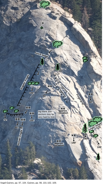 |
|
|
"There are some raps documented as 100', which I guess equates to "I didn't promise you it would work with a 60, but it might with rope stretch." A rappel designated as 100' in the 2001 Guidebook means that you can do the rappel with a 60-meter rope (i.e. less than 30 meters or 98.4 feet). Edit: In my latest guidebooks I use 30 m or 35 m. Back in the old days we used "150 foot" and "165 foot" ropes. |
|
|
Ben Crowellwrote: So some thoughts thinking like a Gumby. If I were to rap from the 90' bolt station (center) to either the bolts to the left (indicated in the image) or bolts to the right, I presume I may have to do a pendulum. Worse case, if I were to pop off trying to traverse on the rock, could I be at risk of swinging and injuring myself? |
|
|
Gumby Kingwrote: Yes, “false sense of security”. |
|
|
Gumby Kingwrote: I agree that there definitely needs to be both some general warning text and some warning text specific to the center area of this diagram, which is called Flintstone Slab. The main warning that I think is probably appropriate for Flintstone Slab is the one that was already on there, which is that I think it would be extremely hard to locate the anchors at all. I suspect the tilt angle is probably not anywhere near as bad as it looks on the diagram, because of the dome shape of the slab, and there probably isn't as much risk of penduluming as you might think from the perspective view. If you look at the "diagonal" lines of Angel's Fright and Fingergrip, those are both basically straight uphill, even though they converge. Bob can correct me if I'm wrong, but based on the text in the guidebooks I think the anchors are there to allow people to do the hard slab climbs on Flintstone Slab, and they were planned so that when you get to the top of the slab, you have the option of either rapping off or continuing to the top of the rock. If you've just done one of those climbs and used the anchors, then you know precisely where they are. Here is a revised version with additional warning text. Click to view it full size. 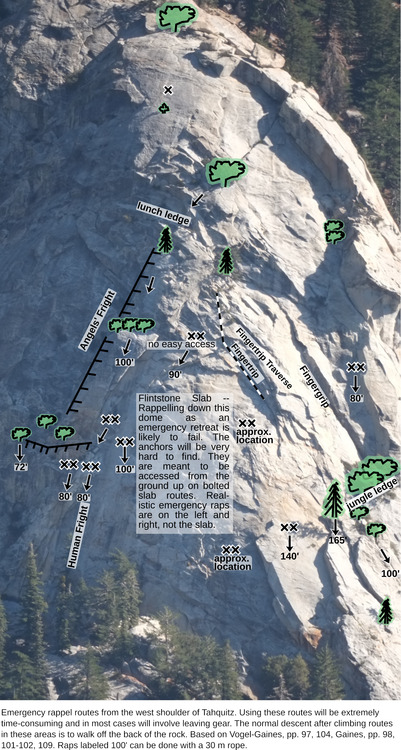 I'm not super interested in debating the psychology of people who might use this information. I can't control other people's behavior or judgment, and they're all individuals with their own personalities and bases of experience. In general people will tend to make the best decisions when they have practical access to accurate information. |
|
|
Here is a diagram for the area from The Trough to Angel's Fright. 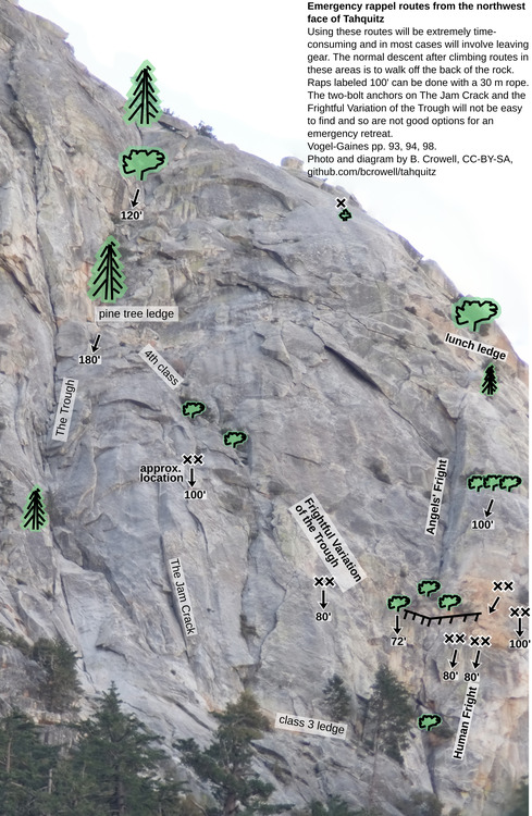 Comments are welcome. |
|
|
Raps labeled 100' can be done with a 60m rope. Edit @Tradi, yeah I never understood why we mix units like this. |
|
|
Yoda Jedi Knightwrote: Or label it 30m rap. |


