|
|
Dallas R
·
Sep 23, 2018
·
Traveling the USA
· Joined May 2013
· Points: 191
Lori, as a weak climber I can give some advice about the giant step aka rock over. You see a nice foot placement too high You lean back, grab you foot and pull it up because you don't have the strength and flexibility to do this with just your foot . Now the foot is on the place you want it to be, but you don't have the strength and agility to just step up. You are off balcance. Sucks!. But you know its a really good foot. It WILL hold when you get there. You don't need jugs to haul yourself up, but it's really nice when you have them. Any minimal friction for balance is what you are looking for, a nub, a pocket, a bulge to palm, doesn't take much, even a flat hand on a flat surface. It's about balance. Lean back, make the effort to stand up, it's ok if you don't make it. Partial is good. Balance is key. You have made half the transition, the following foot is off the comfy place. Simply kick the rock with the following foot, it's just enough to maintain balance while the momentum of the change carries you onto the high foot. If you are balanced it will take maybe once, maybe twice, maybe three times before you are now stable on the high foot. Maybe kick is not the correct communication, stick, step, smear, flag. At this point you are not relying on the following foot, even though you are off balance you are relying on the high foot and the transition to balance. The rest is merely the effort to get recentered.
Nose over toes and balance.
Scared the crap out of me the first few times I tried this.
If this makes no sense at all don't listen to me. I am not an expert.
|
|
|
rgold
·
Sep 23, 2018
·
Poughkeepsie, NY
· Joined Feb 2008
· Points: 526
I think rock-overs come in two parts. First is an dynamic move to get the weight fully on and over the foot. If you move into this part slowly and tentatively, there's a good chance you'll never get your center of gravity over your foot and then you often stall out. The second part requires a lot of leg strength and involves standing up from a position that is close to sitting on your heel. Sometimes at that point you can get the trailing foot on something so that it isn't a one-leg deep knee bend. The attached video illustrates these points pretty well I think. You can also see the continual tapping with the trailing foot that Dallas mentions.
https://www.youtube.com/watch?v=JiCeWxF7bHg
|
|
|
Lori Milas
·
Sep 24, 2018
·
Joshua Tree, CA
· Joined Apr 2017
· Points: 250
Oh, good grief. I had no idea about a rock-over. Dallas, I did A LOT of tapping on the way up with my left foot... on the six or seven moves like that. Thank you for that precise and very understandable coach. Rgold... thank you. That video and your coaching is great! Based on your video, I think this is something that can be practiced in the gym. At this point, I'm coming to understand that this aging thing, for me, is about reclaiming flexibility "with" strength. With no injuries, and basic sound frame, I believe it's all still within reach. What an incredible sport!
Today I would give anything to be back on the rock. I love steep slab. (and Bob's book is incredible). He continually talked about closed crimps on those tiny edges and divots. I was running that through my head thinking those are the dangerous holds for fingers. But this felt different... not like crimping in the gym... just a little more power on the slab. Edging, crimping, and hips seem to be the way up those face climbs. I'd love to get right back there and do that with a little more commitment.
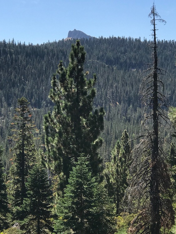
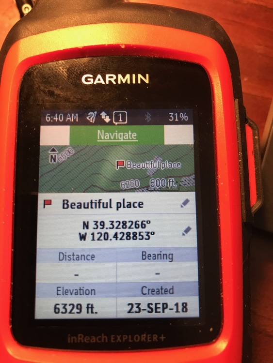
Dallas... or anyone... I have a little project. Please don't worry about it if you don't have a quick idea on this. While out hiking with the grandkids, they pointed to a spire/rock off in the distance. It was jaw-droppingly beautiful. They want to go there, and they thought it would be a 'fun place for you to climb'. So, I took a picture (below) and tried to figure out how I could identify this place. I set my coordinates as a waypoint, and then took a picture of my compass pointing at it. It could be 50-70 miles away as the crow flies, or it could be closer. (no idea!) I'm guessing it's several thousand feet higher than where we were. (Could this possibly be Lovers Leap?)
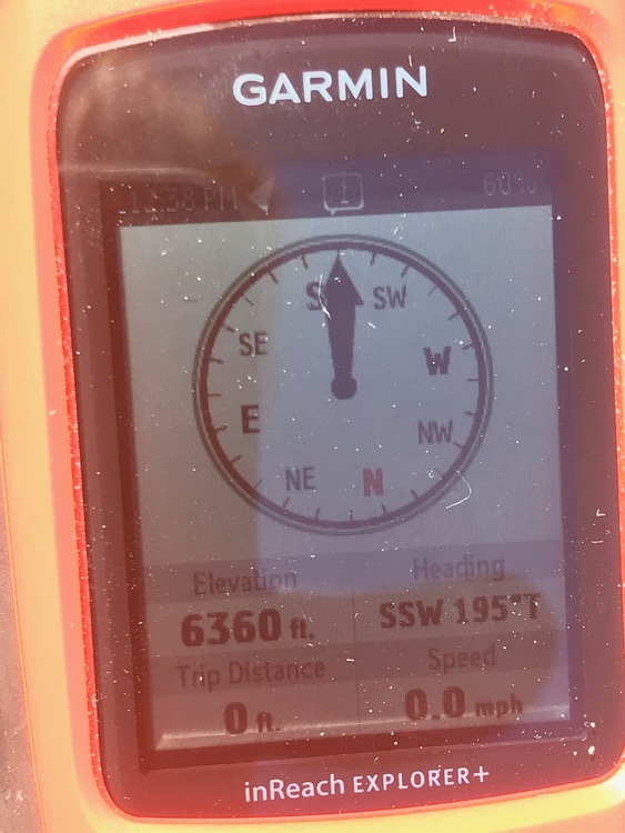
So where we were standing is the kids' "Beautiful Place"... then I pointed the compass at the rock in the distance and took a picture of the direction of the destination rock. So... would I just download the coordinates of where we were onto a topo map, and draw a straight line in the SSW direction... and look for mountains along the way? It would be a gas if it was actually a great climbing spot, and I could do this with the kids. Maybe this is where triangulation comes in?
Picture of rock.
![]() Picture of coordinates. Picture of compass pointing at rock.
|
|
|
Andrew Rice
·
Sep 24, 2018
·
Los Angeles, CA
· Joined Jan 2016
· Points: 11
Here are the coordinates for Lover's Leap. 38.799, -120.141
See if that lines up with your map. If not, you have the general idea, right. Just look at the topo starting from where you were and draw a line on the heading SW 195 degrees. You'll run across your peak.
|
|
|
Old lady H
·
Sep 24, 2018
·
Boise, ID
· Joined Aug 2015
· Points: 1,375
rgold wrote: I think rock-overs come in two parts. First is an dynamic move to get the weight fully on and over the foot. If you move into this part slowly and tentatively, there's a good chance you'll never get your center of gravity over your foot and then you often stall out. The second part requires a lot of leg strength and involves standing up from a position that is close to sitting on your heel. Sometimes at that point you can get the trailing foot on something so that it isn't a one-leg deep knee bend. The attached video illustrates these points pretty well I think. You can also see the continual tapping with the trailing foot that Dallas mentions.
https://www.youtube.com/watch?v=JiCeWxF7bHg
What the guy demonstrates? Is impossible for me. Legs don't scrunch up.like that. However, the basic idea works just dandy: get the foot where you want it next, shift your weight as much as you can, then power up however you can. For me? It looks a lot like what the woman is doing at the start. A lot of oppositional moves. Hang, on a good hand (looks almost like a lay back) to get the foot somewhere, then find something to push on, to help shove the body over, then up.
My head is down, I'm sure I'm looking for the next placement for the right, knowing I can just smear the left anywhere. Such a fun, fun, climb! Whoever it was on here who said I'd have a better time once I got off my coloumnar basalt, was totally correct!
Best, Helen
|
|
|
Lori Milas
·
Sep 24, 2018
·
Joshua Tree, CA
· Joined Apr 2017
· Points: 250
I like this sentence from Bob Gaine's book: "When doing a high step, lead with your hips, shifting them in to the wall and in the direction you're stepping, until your center of gravity has shifted to that upper foothold."
It might be just a subtle adjustment, but it may be that trying to muscle up in bad form makes it all harder. Lead with the hips... will try it this week at the gym.
|
|
|
Old lady H
·
Sep 24, 2018
·
Boise, ID
· Joined Aug 2015
· Points: 1,375
Lori Milas wrote: I like this sentence from Bob Gaine's book: "When doing a high step, lead with your hips, shifting them in to the wall and in the direction you're stepping, until your center of gravity has shifted to that upper foothold."
It might be just a subtle adjustment, but it may be that trying to muscle up in bad form makes it all harder. Lead with the hips... will try it this week at the gym. Yeah, shifting the hips. You can do a sorta dumb looking side to side thing, going up a really easy wall in the gym. Try to go slowly and be very exact, also. That's what I was doing on the autobelay last winter. Not just dialing a 5.9 lead, (mock lead on the auto, of course), but making it exact. Look for the next foot, know exactly how you want to place it. Decide. Do. Watch that placement until it's done. Kinda like a golf swing follow through, not that I play golf. Watching your foot placements, very literally, and making them precise? Direct advice from Joe Healy to my climbing partner. Said partner is now on sighting tough trad. I'm often saying to myself, "there ya go, Joe, thanks!" when I stand on some dinky nub of nuthin, piece of cake often, now, if the foot and weight are correct.
Bouldering Wednesday! I have a feeling we'll be going hard this week. My guy has deemed me "at least a VB". Hmmmm....I think he's going to test that "at least", lol! Happily, everything near us is relatively close to the ground. Not like what our hardmen in Oz are on, thank goodness!
Best, Helen
|
|
|
Carl Schneider
·
Sep 24, 2018
·
Mount Torrens, South Australia
· Joined Dec 2017
· Points: 0
Lori Milas wrote:
...
Dallas... or anyone... I have a little project. Please don't worry about it if you don't have a quick idea on this. While out hiking with the grandkids, they pointed to a spire/rock off in the distance. It was jaw-droppingly beautiful. They want to go there, and they thought it would be a 'fun place for you to climb'. So, I took a picture (below) and tried to figure out how I could identify this place. I set my coordinates as a waypoint, and then took a picture of my compass pointing at it. It could be 50-70 miles away as the crow flies, or it could be closer. (no idea!) I'm guessing it's several thousand feet higher than where we were. (Could this possibly be Lovers Leap?)
So where we were standing is the kids' "Beautiful Place"... then I pointed the compass at the rock in the distance and took a picture of the direction of the destination rock. So... would I just download the coordinates of where we were onto a topo map, and draw a straight line in the SSW direction... and look for mountains along the way? It would be a gas if it was actually a great climbing spot, and I could do this with the kids. Maybe this is where triangulation comes in?
Picture of rock.
Picture of coordinates.
Picture of compass pointing at rock. Convert the magnetic bearing to a grid bearing. You already know the ref point. Subtract the grid magnetic variation. Look on the map to see what it was when the map was printed and how much and in what direction it changes. You can't just draw the magnetic bearing on the map, but if you did, it wouldn't be that much out, that is a big feature it should be quite easy to see on the map.
|
|
|
Dallas R
·
Sep 24, 2018
·
Traveling the USA
· Joined May 2013
· Points: 191
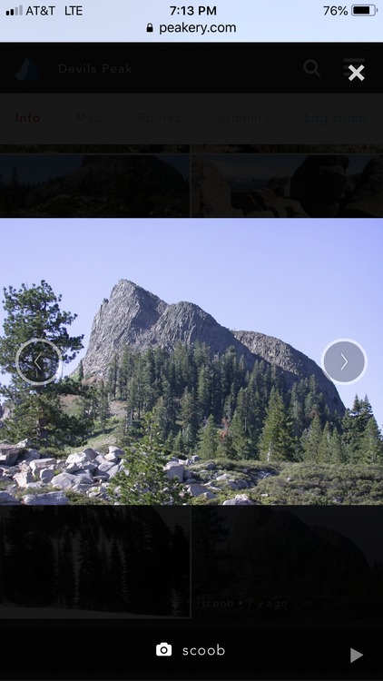
I am in COR without good internet, quick calculation with tools on hand, Devils Peak, 39.284183, -120.440745.
|
|
|
Jeffrey Constine
·
Sep 24, 2018
·
Los Angeles, CA
· Joined May 2009
· Points: 674
I don't want to be found lol, GPS for crags lol~
|
|
|
Dallas R
·
Sep 24, 2018
·
Traveling the USA
· Joined May 2013
· Points: 191
Jeffrey Constine wrote: I don't want to be found lol, GPS for crags lol~ One of the great debates when I was in middle school was to allow the use of calculators in the school. Calculators are tools. GPS is simply a tool. They both assist but do not replace the need for knowledge and understanding. Good GPS coordinates assist us in finding a climb we wish to attempt. It is one of many tools that I use to find routes. Because every area we go to is new to us I can use all the help I can get. Exploring is one of the fundamentals of an outdoorsman. I love to poke around, but alas, time is critical. We only have a limited time before we move on. Thus, GPS is helpful. If I was a strong climber I would simply just onsite everything. No need for GPS, beta, guidebooks, MP, bolts, etc. That's my heart, but not my ability.
|
|
|
Harumpfster Boondoggle
·
Sep 24, 2018
·
Between yesterday and today.
· Joined Apr 2018
· Points: 148
Nothing wrong with GPS...but battery life and an electronic device is nothing I would stake my life on.
Proper map and compass skills are required in the back country.
|
|
|
Lori Milas
·
Sep 24, 2018
·
Joshua Tree, CA
· Joined Apr 2017
· Points: 250
Dallas R wrote: I am in COR without good internet, quick calculation with tools on hand, Devils Peak, 39.284183, -120.440745. Dallas...wow! That looks like it! Thank you! I will figure out how you did this. That’s awesome!
|
|
|
rgold
·
Sep 24, 2018
·
Poughkeepsie, NY
· Joined Feb 2008
· Points: 526
You map and compass purists need to chill. She isn't navigating in the back country, she's trying to identify a distant landmark after she got home. She has two pieces of info:
(1) A compass bearing from her location to the landmark. She got it with an electronic compass, but could have done exactly the same thing with a handheld compass. The only difference is that she gets a more accurate bearing from the electronic compass since it does the hair-splitting for her.
(2) She has coordinates of her location. If she had a map with her, had good map orientation skills, was in terrain that provided adequate clues or triangulation reference points, and had weather that cooperated, she could have gotten less accurate set of coordinates for her location. Since she had a device, she can just read that info directly off the screen. So much better than map and compass! Moreover, if she was just on a little mapless stroll with the family, the the GPS coordinates give her a location she couldn't have otherwise recovered later at home.
Ok, now a certain amount of inexpert activity did occur...Lori could easily have saved the waypoint indicating her location and the bearing from that waypoint to the distant landmark, absolutely no need to have a second electronic device to take a picture of the screens on the first device!
There is a technical detail mentioned by Carl (which would have been present whether Lori used a compass or GPS unit), and that is the effect of magnetic declination. For purposes of transferring to a map, the bearing eventually has to be one that includes the effect of the magnetic declination. All halfway decent compasses allow you to make a declination correction so that the readings are relative to true North. GPS units (when they use their magnetic compass) typical adjust automatically for declination---true North is the default setting. Assuming the defaults haven't been changed (to something like "magnetic,") the bearing on Lori's screen is relative to true North and doesn't need any of the declination adjustments mentioned by Carl---they have already been applied. (Honestly, no matter what device you use for navigation, no one should be hand-correcting for magnetic declination in the 21st century.)
Having the declination correctly added or subtracted matters quite a lot for Lori's purposes. If the declination correction is erroneously not applied, then her bearing line is going to be off by about 10 degrees, introducing an error of about 900 feet per mile. If the landmark is 20 miles away, her uncorrected bearing line is going to miss by more than three miles, which might add a lot of confusion.
Assuming the default settings for true North bearings are in effect in her GPS, she locates her waypoint on a map as accurately as she can and, using an ordinary protractor, plots the bearing angle and draws a straight line. Of course, all this can be done on a computer with some basic mapping software too.
|
|
|
Carl Schneider
·
Sep 24, 2018
·
Mount Torrens, South Australia
· Joined Dec 2017
· Points: 0
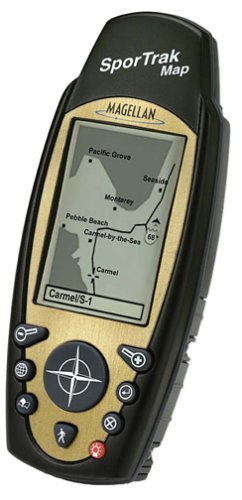
rgold wrote: ... Assuming the defaults haven't been changed (to something like "magnetic,") the bearing on Lori's screen is relative to true North and doesn't need any of the declination adjustments mentioned by Carl---they have already been applied. (Honestly, no matter what device you use for navigation, no one should be hand-correcting for magnetic declination in the 21st century.)... Ha ha. Yeah, true, I was harking back to my army days which, actually, were of course last century, as they would be for a lot of us on this thread Sorry to get all technical esp as it was not needed. Ages ago, when I was out of the army and wanting to practice map to ground navigation (for some odd, esoteric reason) I'd normally use a Silva compass for a magnetic bearing, I've never used my old Magellan SporTrak Map GPS (also from last century) to take a magnetic bearing as I always has the compass. I used to love fu*&ing around with the GPS and maps, but it was really annoying when serial ports (remember them) disappeared from computers. I never could get a USB port to emulate a serial port properly so I could download the waypoints onto Ozi ezplorer (http://www.oziexplorer.com/au/). I'd scan my topographic maps using a flat bed scanner and calibrate them, then the waypoints would be overlaid on the map. It was cool fun. Anyhoo, two sleeps until I'm at Moonarie doing some trad climbing!!! https://www.thecrag.com/climbing/australia/moonarie
PS, what about having to manually adjust for declination AND convert bearings in minutes and seconds to degrees, hmmm? Now THAT's a last century skill.
PPS, let me know if I've overdone the links. I don't stop until you tell me I've overdone stuff. Seriously.
2000 Man Carl Who Overthinks Everything
https://youtu.be/4DLKoOs3IpU
|
|
|
Old lady H
·
Sep 24, 2018
·
Boise, ID
· Joined Aug 2015
· Points: 1,375
Okay, boys and girls, my GPS story.
A long time ago, in a galaxy far, far away ..
Wait. Wrong story.
30ish plus years back, my friend was a BLM guy, when they were reintroducing desert bighorn in southern Idaho. Did lots of fun stuff with him out in our rather huge desert south of here. Including simulating hikers by, errr, hiking, to the canyon where the sheep were. His partner watched with a spitting scope from a blind, to see how they reacted. We got to watch the sheep watching us, including some little ones, with binoculars. Part of our cover. Ahem.
One of the projects he enlisted help with was a plant survey, specifically to lay the groundwork for a study on juniper trees and rangeland. So, there we were, laying out plots, measuring stuff, and counting and recording every bit of everything growing in certain parts of the grid we had staked out.
All of this had to be meticulously mapped, an interesting proposition back then, in the middle of nowhere.
But! Enter our hero! Global Positioning Satellites! 1980s. Which means, these were government satellites, you had to first know about them, then have permission to use them, and have the equipment to do so.
Further? You had to be in a certain spot at a certain time. Because that's when a lofty three satellites would be over the horizon! Yay!
Enter my job. While he fiddled with his telemetry whizmos? I stood there holding a rather large antenna propped on top of my head. Way before phones took photos....or even left the house, for that matter. The cows were entertained, at least.
All this, put him within ten or twenty feet of accuracy, a thrilling accomplishment back then.
So if you live near BLM land where there is now juniper eradication going on (rangeland, you know) you have me to partly blame for that!
Best, Helen
|
|
|
wendy weiss
·
Sep 24, 2018
·
boulder, co
· Joined Mar 2006
· Points: 10
Helen, my mental image of you with a large antenna on your head is priceless. Oh to have had camera phones back then.
|
|
|
Lori Milas
·
Sep 25, 2018
·
Joshua Tree, CA
· Joined Apr 2017
· Points: 250
rgold wrote: You map and compass purists need to chill. She isn't navigating in the back country, she's trying to identify a distant landmark after she got home. She has two pieces of info:
(1) A compass bearing from her location to the landmark. She got it with an electronic compass, but could have done exactly the same thing with a handheld compass. The only difference is that she gets a more accurate bearing from the electronic compass since it does the hair-splitting for her.
(2) She has coordinates of her location. If she had a map with her, had good map orientation skills, was in terrain that provided adequate clues or triangulation reference points, and had weather that cooperated, she could have gotten less accurate set of coordinates for her location. Since she had a device, she can just read that info directly off the screen. So much better than map and compass! Moreover, if she was just on a little mapless stroll with the family, the the GPS coordinates give her a location she couldn't have otherwise recovered later at home.
Ok, now a certain amount of inexpert activity did occur...Lori could easily have saved the waypoint indicating her location and the bearing from that waypoint to the distant landmark, absolutely no need to have a second electronic device to take a picture of the screens on the first device!
There is a technical detail mentioned by Carl (which would have been present whether Lori used a compass or GPS unit), and that is the effect of magnetic declination. For purposes of transferring to a map, the bearing eventually has to be one that includes the effect of the magnetic declination. All halfway decent compasses allow you to make a declination correction so that the readings are relative to true North. GPS units (when they use their magnetic compass) typical adjust automatically for declination---true North is the default setting. Assuming the defaults haven't been changed (to something like "magnetic,") the bearing on Lori's screen is relative to true North and doesn't need any of the declination adjustments mentioned by Carl---they have already been applied. (Honestly, no matter what device you use for navigation, no one should be hand-correcting for magnetic declination in the 21st century.)
Having the declination correctly added or subtracted matters quite a lot for Lori's purposes. If the declination correction is erroneously not applied, then her bearing line is going to be off by about 10 degrees, introducing an error of about 900 feet per mile. If the landmark is 20 miles away, her uncorrected bearing line is going to miss by more than three miles, which might add a lot of confusion.
Assuming the default settings for true North bearings are in effect in her GPS, she locates her waypoint on a map as accurately as she can and, using an ordinary protractor, plots the bearing angle and draws a straight line. Of course, all this can be done on a computer with some basic mapping software too. Rgold... you may be tired of hearing constant 'thank you's'. but thank you. In every way, I appreciate your time. It means a lot to me to not be completely helpless outdoors... and yet none of this is intuitive. Reading Carl's instructions (thank you, Carl!) was how I expected it to be... completely Greek to me! So, like everything else, this is plodding along. Trying to find time to pull out the navigation book and maps and compass again... I wish I could hang out with a group of guys, or a Boy Scout troop, and just learn on the fly. This is the next best thing.
The GPS does solve for declination, so I don't have to do that. It ALSO would have given me a bearing on the same reading. I just wasn't certain how to get that. I'm guessing if I could have climbed to another spot, and taken those readings, I could have then found the spot most exactly. So, lesson learned... but I would love to be able to pull out my compass and map, know exactly where I'm headed. This will take awhile. And lots of field practice.
While in the desert I practiced at the outdoor mall, which is enormous. Set waypoints at Saks Fifth Avenue, Polo and The North Face... nevermind the looks I got walking from store to store with my GPS unit. There are signs everywhere in the desert "Your GPS will not work in Joshua Tree". There are also signs for missing persons, one who is in my prayers... set out on a hike July 31. He has not been heard from since.(And yet still they were sending out another search party last weekend...) The two REI instructors for the classes I took up in Sacramento balked when I asked about navigating the desert--whatever they would teach in the Sierras would not work in the desert. So, apparently, desert navigation is its own animal.
---------------------------
Totally on another subject, I'm still absorbing the advice of Bob Gaines after a week with him. His advice was to take it slow... and he didn't want to work on multi-pitch climbs until I could guarantee that I would have no diabetic trouble ever at a halfway point. I'm talking with other Type 1 Diabetics... it's a real concern. "Lori, there's 8,000 single pitch climbs in this park. Let's work on those." He was casting no aspersions on my strength or ability... in fact, he said he was surprised. But he's cautious and casual... 'these rocks will still be here next year.'.
He also had a serious discussion about lead climbing... maybe because he is a guide, I don't know... he sees no rush for that. Do I want to climb 5.9's and 5.10's and gain those skills... or hunker down and learn to lead on 5.3's. He asked me honestly "At this time of your life, how much risk do you really want to take?" But he did send me home with instructions to get that lead certificate at the gym, hit some sport routes outside, and decide along the way. And learn all the knots in his book. So... a winter project.
Kind of hard advice to accept... I guess El Cap is out of my immediate future. But lots of cracks, chimneys, slab... all over the state, and wherever I can find a partner.
|
|
|
Lori Milas
·
Sep 25, 2018
·
Joshua Tree, CA
· Joined Apr 2017
· Points: 250
Old lady H wrote: Okay, boys and girls, my GPS story.
A long time ago, in a galaxy far, far away ..
Wait. Wrong story.
30ish plus years back, my friend was a BLM guy, when they were reintroducing desert bighorn in southern Idaho. Did lots of fun stuff with him out in our rather huge desert south of here. Including simulating hikers by, errr, hiking, to the canyon where the sheep were. His partner watched with a spitting scope from a blind, to see how they reacted. We got to watch the sheep watching us, including some little ones, with binoculars. Part of our cover. Ahem.
One of the projects he enlisted help with was a plant survey, specifically to lay the groundwork for a study on juniper trees and rangeland. So, there we were, laying out plots, measuring stuff, and counting and recording every bit of everything growing in certain parts of the grid we had staked out.
All of this had to be meticulously mapped, an interesting proposition back then, in the middle of nowhere.
But! Enter our hero! Global Positioning Satellites! 1980s. Which means, these were government satellites, you had to first know about them, then have permission to use them, and have the equipment to do so.
Further? You had to be in a certain spot at a certain time. Because that's when a lofty three satellites would be over the horizon! Yay!
Enter my job. While he fiddled with his telemetry whizmos? I stood there holding a rather large antenna propped on top of my head. Way before phones took photos....or even left the house, for that matter. The cows were entertained, at least.
All this, put him within ten or twenty feet of accuracy, a thrilling accomplishment back then.
So if you live near BLM land where there is now juniper eradication going on (rangeland, you know) you have me to partly blame for that!
Best, Helen Helen! I've been so caught up in my own stuff I haven't asked... how was your trip? I love your picture! You look great on that wall! It sounds like you had a great time... and I thought of you often while I was also out. And you got a hit of granite... ... or something more sticky, which must have been wonderful. Everything went well?
|
|
|
wendy weiss
·
Sep 25, 2018
·
boulder, co
· Joined Mar 2006
· Points: 10
"Set waypoints at Saks Fifth Avenue, Polo and The North Face...." Survival coordinates for life.
Here's a thought. Even if you don't want to learn to lead trad yet, if Bob's setting up TRs for you, you might ask him to lead some of the climbs instead. That way you'd get experience on removing pro, which is also a good way to learn how to place it. At least that's mostly how I learned.
|

 Continue with onX Maps
 Sign in with Facebook