Tower Wall tier Climbing
Use onX Backcountry to explore the terrain in 3D, view recent satellite imagery, and more. Now available in onX Backcountry Mobile apps! For more information see this post.
| Elevation: | 518 ft | 158 m |
| GPS: |
41.14491, -74.16518 Google Map · Climbing Area Map |
|
| Page Views: | 860 total · 9/month | |
| Shared By: | kenr on Dec 28, 2016 | |
| Admins: | Morgan Patterson, SMarsh |
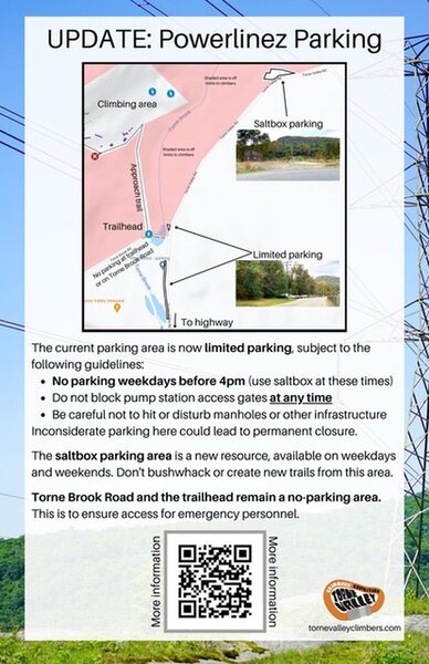
 Access Issue: As of November 2021, there are new parking arrangements. Please follow this guidance.
Details
The current parking area is now limited parking, subject to the following guidelines:
No parking weekdays before 4pm. (Use Saltbox Parking Area at these times).
Do not block pump station access gates at any time.
Be careful not to hit or disturb manholes or other infrastructure.
The Saltbox Parking Area is a new resource, available on weekdays and weekends. Don't bushwhack or create new trails from this area.
Torne Brook Road and the trailhead remain a no-parking area. This is to ensure access for emergency personnel.
Inconsiderate or illegal parking here could lead to permanent closure.
Description

More for roped climbing than bouldering.
includes a couple of problems in the Sunny Picnics sector (and perhaps a traverse across the bottom of the Tower Wall).
. (There would be some nice problems on the right half of the Tower Wall, but they have bad landings).
Currently descriptions and photos for these problems are under the "roped climbing" part of Mountain Project's Powerlinez area:
Getting There

The Tower Wall is easily visible while driving in on Torne Valley Rd. Several ways to get there. The easiest (though not the shortest) is to start North up the dirt road for the trailhead about 1350 feet to the second intersection. Turn Left and go SouthWest about 500 feet to an intersection. Turn Right (NW) up short steep hill, then curve Left and go flat WSW another 200 feet.
Weather Averages
|
High
|
Low
|
|
Precip
|
Days w Precip
|
Prime Climbing Season
| J | F | M | A | M | J | J | A | S | O | N | D |
| J | F | M | A | M | J | J | A | S | O | N | D |
Photos
- No Photos -
All Photos Within Tower Wall tier
Most Popular · Newest · RandomMore About Tower Wall tier
Printer-FriendlyWhat's New
Guidebooks (3)

 Continue with onX Maps
 Sign in with Facebook


0 Comments