Snake Hole Left Bouldering
Use onX Backcountry to explore the terrain in 3D, view recent satellite imagery, and more. Now available in onX Backcountry Mobile apps! For more information see this post.
| Elevation: | 530 ft | 162 m |
| GPS: |
41.14621, -74.17002 Google Map · Climbing Area Map |
|
| Page Views: | 7,790 total · 79/month | |
| Shared By: | Systematic on Dec 27, 2016 · Updates | |
| Admins: | Morgan Patterson, SMarsh |
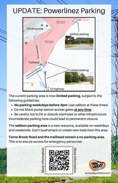
 Access Issue: As of November 2021, there are new parking arrangements. Please follow this guidance.
Details
The current parking area is now limited parking, subject to the following guidelines:
No parking weekdays before 4pm. (Use Saltbox Parking Area at these times).
Do not block pump station access gates at any time.
Be careful not to hit or disturb manholes or other infrastructure.
The Saltbox Parking Area is a new resource, available on weekdays and weekends. Don't bushwhack or create new trails from this area.
Torne Brook Road and the trailhead remain a no-parking area. This is to ensure access for emergency personnel.
Inconsiderate or illegal parking here could lead to permanent closure.
Description

This is the first boulder you'll see when coming down the trail just at the left of the Army Strong area. It is easily identified by the presence of a big shelf on the left side of the boulder with a small cave below containing a small boulder / big rock on the left side. You'll see chalked holds inside the cave to the right of the big rock.
Getting There

First hike up on the usual trails to Basilisk wall, then walk WNW horizontally along the base of the low cliffs passng by the Immelman. Strategic Air Command sectors, and the Army Strong sector, and then continue on the small trail down and left to the lower tier. Snake hole is the first boulder you'll see.
Classic Climbing Routes at Snake Hole Left
Mountain Project's determination of the classic, most popular, highest rated climbing routes in this area.
Weather Averages
|
High
|
Low
|
|
Precip
|
Days w Precip
|
Prime Climbing Season
| J | F | M | A | M | J | J | A | S | O | N | D |
| J | F | M | A | M | J | J | A | S | O | N | D |
All Photos Within Snake Hole Left
Most Popular · Newest · RandomMore About Snake Hole Left
Printer-FriendlyWhat's New
Guidebooks (3)

 Continue with onX Maps
 Sign in with Facebook


1 Comment