
 Continue with onX Maps
 Sign in with Facebook


Aculco Rock Climbing
| Elevation: | 7,550 ft | 2,301 m |
| GPS: |
20.15101, -99.91305 Google Map · Climbing Area Map |
|
| Page Views: | 29,090 total · 219/month | |
| Shared By: | Gunkswest on Jan 4, 2015 · Updates | |
| Admins: | Ricardo Orozco, Mauricio Herrera Cuadra |
Description

This area is very reminiscent of Paradise Forks in Arizona. Called by some the "Indian Creek of Mexico," the climbs are predominantly 30-210 foot high cracks between rhyolite columns. The canyon containing the cliffs has several large bends, making for sunny or shady climbing possibilities depending on the time of day and year.
The area is covered in detail within the La Concepcion Guidebook for Mexico on Rakkup and The Mexican Rock Climbing Guide Center-South (March 2013) pages 128-150. These guides list over 100 climbs from 5.7 to 5.12a. You'll likely want doubles or triples of cams and a 100 foot long chunk of anchor rope. It's also likely you'll find the grades in the guidebook to be stiffer than other areas (5.7 here is akin to 5.8 or 5.9 in Joshua Tree).
Just above the canyon on the Amealco (west) side is a business that sells carved stone (Venta de Sillar La Cascada). The owner (as of 01-2016), Mr. Martin Jimenez, and his family used to live in Reno, NV and speak English. They are great folks. Stop in and say hello!
You can camp right above the cliffs. The drawback is the frequent blasting that occurs in the nearby quarry.
The beautiful town of Aculco has numerous markets, dozens of eateries and several hotels. A room can be had at the Hotel Hidalgo in downtown Aculco for about $30US/night. Rooms can be reserved in advance via their Facebook page. They will also allow you to take showers without renting a room (50p for two people as of 01-2016).
The town of Amealco is worth a visit if you have a rest day or the weather is uncooperative. On the way to Amealco, stop and check out the "old school" rock quarrying operation alongside the road - amazing!!!!!
Getting There
The Aculco climbing area is located a short distance from Mexico Highway 55 about an hour to the south of Queretaro and roughly two hours north of Mexico City in the state of Mexico. It is about a 70 minute drive between Jilotepec and Aculco.
From the Aculco exit of Highway 55, travel west about 10 kilometers toward the town of Amealco. The canyon containing the climbs will be just off the right (roughly northwest) side of the road near a cascade. The approach takes roughly 2-20 minutes, depending on which section of the canyon you go to.
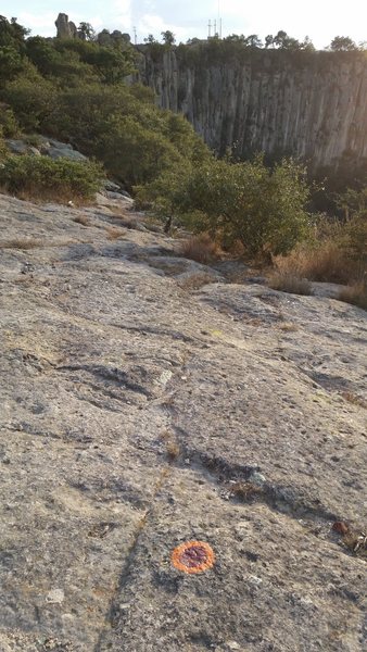
From where you park, just off the road on a slab of rock, look left a few yards (toward the power poles at the top of the cliff) for orange and red circles painted on the rock. These marks denote the climber access trail and will take you easily down to the base of the cliff. The blazes then continue along the base of the cliff to The Prow. This descent is much more straightforward then the "Red Tree" (now grey stump) descent.

Classic Climbing Routes at Aculco


Weather Averages
|
High
|
Low
|
|
Precip
|
Days w Precip
|
| J | F | M | A | M | J | J | A | S | O | N | D |
| J | F | M | A | M | J | J | A | S | O | N | D |
Photos


All Photos Within Aculco
Most Popular · Newest · RandomMore About Aculco
Printer-FriendlyWhat's New


2 Comments