Stoked Bowl Rock Climbing
| Elevation: | 7,330 ft | 2,234 m |
| GPS: |
39.7424, -105.4104 Google Map · Climbing Area Map |
|
| Page Views: | 11,961 total · 75/month | |
| Shared By: | EricJochens on Nov 13, 2012 | |
| Admins: | Leo Paik, John McNamee, Frances Fierst, Monty, Monomaniac, Tyler KC |
 Access Issue: Seasonal Raptor Closures
Details
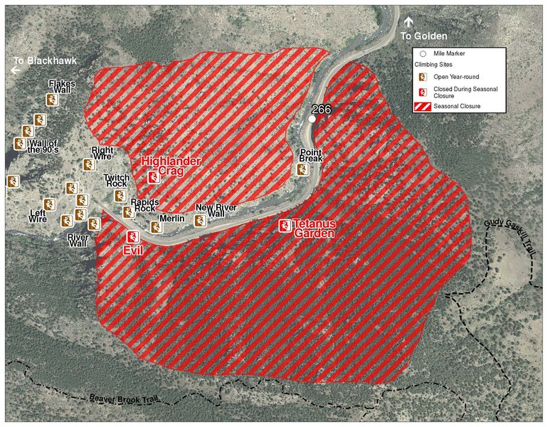
Raptor Closures Effective February 1-July 31
Visit: jeffco.us/open-space/news/2…
Tunnel 1 closure
For more details visit: jeffco.us/open-space/alerts…
The two areas Jefferson County Open Space intends to close in Clear Creek Canyon, shown on the attached maps, encompass the active eagle nests. If the Clear Creek eagles continue to nest in the active nests, these areas will remain closed from February 1 through July 31. If the eagles choose different nesting sites, the closures will be adjusted accordingly to protect those eagles during their breeding season.
Currently, rock climbing areas that fall inside of the seasonal raptor closures include:
Blonde Formation
Bumbling Stock
Evil Area
Ghost Crag
Highlander
Skinny Legs
Stumbling Block
Tetanus Garden
Fault Caves
 Access Issue: Private Property - be aware & respectful
Details
Description

This is secluded. It has the same rock as the rest of Clear Creek Canyon. It is best known for the best highline slacklining in the state. There are some new sport climbs going up.
Highlines:
"I'm on TV", 140' long and 100' high.
"Coloradical", [180'] long and 60' high.
"Rad Ass Hoodie", 84' long and 45' high.
Coloradder Than You, 265', just above Coloradical.
Getting There

Expect a 20 minute, steep approach. The trail starts (39.743065N 105.406969W) on the west end of Tunnel 5, cross over the North side of the bridge so you can be on the north side of the river. Hike along the river to the West until you see a small trail leading up the canyon to your right (North). The trail is difficult and not well marked, but there are some cairns along the way. The trail travels over the saddleback of the ridge to the West of the canyon to the next canyon at its top.
Here is the recorded track from Motion-X GPS:
Date: Nov 18, 2012 9:13 am
Distance: 0.27 miles
Elapsed Time: 19:53.0
Avg Speed: 0.8 mph
Min Altitude: 6,903 ft
Max Altitude: 7,366 ft (463 feet gain)
Start Location: 39.743436ºN 105.406820ºW
End Location: 39.742322ºN 105.410231ºW GPS Map: (valid until May 18, 2013)
L>R:
A. Get Stoked, 10, 75', 1p, bolts.
B. Don't Hate, 12+, 80', 1p, bolts.
C. Unknown Roof, 13?, 1p, bolts.
D. Try These Nachos, 9+, 1p, 60', bolts.
E. Hydromania, 13-, 1p, 55', bolts.
F. Free Immersion, 13+, 1p, 50', bolts.
G. Clouds In My Coffee, 13, 1p, 50', bolts.
H. Hateraid, 11-, 1p, 25', bolts.
I. Haters Gunna Hate, 11-, 1p, bolts.
Classic Climbing Routes at Stoked Bowl
Weather Averages
|
High
|
Low
|
|
Precip
|
Days w Precip
|
| J | F | M | A | M | J | J | A | S | O | N | D |
| J | F | M | A | M | J | J | A | S | O | N | D |
Photos
All Photos Within Stoked Bowl
Most Popular · Newest · RandomMore About Stoked Bowl
Printer-FriendlyWhat's New
Guidebooks (16)

 Continue with onX Maps
 Sign in with Facebook


5 Comments