
 Continue with onX Maps
 Sign in with Facebook


Holcomb road access changes


|
|
Tried to go to Holcomb pinnacles Friday 3/20. The forest road past Wilbur grave seemed to be significantly narrowed by metal posts and cable fencing installed along the edge of the road on both sides. This is right where the deepest ponding of water occurs and in this case was impassable by my outback, probably about 2’ deep of water, and the fencing prevented any way of going around it. From what I’m remembered in the fall when I was here there was always a way around this deep part to avoid it. Forgot to take photos, but This is right after the nicer gate for the property on the north side. It seems very different, curious if anyone else has noticed this? It’s going to significantly affect access for non 4x4’s after any rain event most likely. They basically made it a choke point at this location of the deep spot. Obviously there was a lot of snow melt recently. This probably will take a bit to dry out enough currently to be able to get through for a normal car. |
|
|
Bumping this, anyone know if this new fencing is legit/legal or what the story is? It seems as if the camp owner is trying to control and limit access as there is obvious break points in fence with pad locks for 2wd access around the pond in question. |
|
|
unfortunately, it gets worse than that. I heard last year from the Rangers that they’re going to start cracking down on the camping at the main parking lot. I don’t understand what their purpose is, but apparently they’re gonna start trying to make that whole area legit. I hope to God that’s not true. It’s one of the last places to have fun without a reservation. |
|
|
Enemies of fun
|
|
|
everbradwrote: That is exactly my concern…I guess need to start with checking in with the ranger station about it. |


|
Is this something that the Access Fund could help with? It’s National Forest, correct? Are there use precedents that might apply? I only go up there about once a year, but maybe informed locals could chime in. Rim of the World Climbing Club might be useful to contact. |
|
|
According to OnX, there is a sliver of road near Wilbur's Grave that is owned by a Boy Scout group. Not sure if that is where the fencing has been installed. Personally, I would rather effort by the FS be applied to fining people for illegal and dangerous fires in the parking lot and on the trails(yes, I have seen people camping on the trail in) and adding a restroom or wagbag station in the parking lot. But, we tried to advocate for that 15 years ago to no avail. Access Fund was not helpful because they work with private lands, not federal land. Maybe they changed their tune since then. IDK. |
|
|
I'm kinda surprised no one else is saying anything, I know it's early season but it's been hot and people are definitely going out there plus that pond will just fill back up after summer storms, and access shouldn't be limited to 4x4s and people who know the boyscout camp owners so they can just take off the padlocks. Wish we would have taken pictures because the fence is in both sides of the road, does the camp really own all that property and the access road cuts through it? The access fund doesn't seem to be interested in getting involved here outside of Josh and idylwild unfortunately (read Williamson rock) and usfs has so little budget now, but still hopeful this gets resolved |
|
|
everbradwrote: From what we understand, Access Fund works to get access to privately owned lands, not Federal. Thus, they aren't interested or have no jurisdiction in JT or Idyllwild. Probably not Holcomb because those are all Forest Service and mine claims. But, there are a few slivers of private land back there. |
|
|
Carey De Lucawrote: Access Fund isn’t, and hasn’t, done squat for climbing access. Just a bunch of lawyers blowing hot gas. |
|
|
Carey De Lucawrote: This is entirely incorrect. The Access Fund works extensively with Federal, State and local government entities as well as some private landowners. It was instrumental in reversing a Federal ban on bolts in wilderness just last year. It also works with local climbing organizations who have knowledge of their climbing areas. Sounds like people should do some investigating as to land ownership and USFS' road easements. Visit their website if you want to learn what they do and what they have done. Williamson was closed due to an endangered frog, defunding of USFS budgets to implement mitigation plans, not lack of effort. |
|
|
The Access Fund played a key role in negotiating the Suicide Rock access trail (USFS land) dispute back in the early 90’s- Randy could speak to this I believe. AF crews built the stairs at the start of the Suicide climbers trail about ten years ago (which have since been improved by the Idyllwild Climbers Alliance). As mentioned, they have been directly and effectively related to climber advocacy interests on most any land since their inception. |
|
|
It seems like what is needed is a few big dump truck loads of gravel to be dumped in the big puddles. Has anyone talked to the USFS about this? |
|
|
tom donnellywrote: This has been needed for the past 10 plus years... Some of roads accessing other areas are actually in much worse shape |
|
|
Jon Hartmannwrote: It's a tough call. Obviously I don't need to camp there. A few years back we cleaned up over 30 new fire rings in that area. I live in fear of the whole place being burned to the ground. |
|
|
|
|
|
Okay folks a lesson in civics. They suck but ya gotta learn before bitching like Guy which I take great exception to. When something changes that relates to roads and/or property one should first start looking at the county parcel maps which identifies ownership. Attached is a map showing various parcels from San Bernardino County: arcpropertyinfo.sbcounty.gov/ 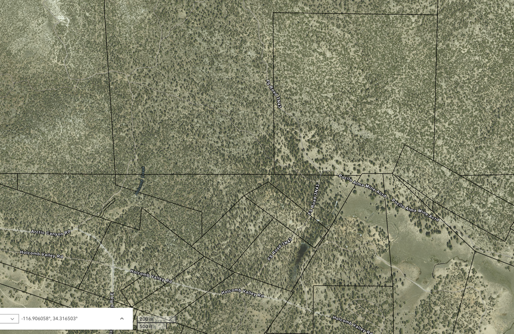 While it does not show ownership, it shows the parcels. One would need to search the San Bernardino County parcel maps which are typically online to get the ownership. Left as an exercise for the locals. But here is a start from: https://open.sbcounty.gov/datasets/0b5ac95331bb4be29b2a1aa2a94abc7b_0/explore?location=34.304549%2C-116.904195%2C16 Note parcels with no land value are likely publicly owned because they are not taxed. The one I have highlighted has a value thus is likely privately owned. Whether this is the parcel in question with the fence is left as an exercise for the locals. 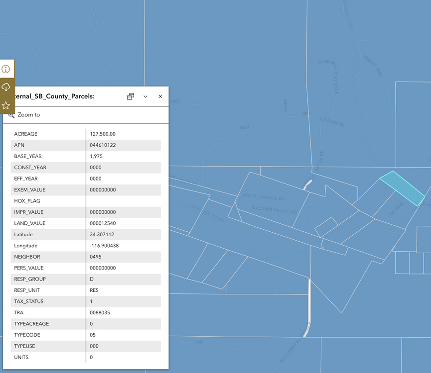 Next, given the parcel map it is likely that the road in question goes through private property via a county right-of-way. The width of the county right-of-way varies based on the location. Once can find that in the County Roadway Designations. That document might or not might be applicable. But for the sake of the exercise let's assume it is applicable and there is a 60' right-of-way. Given there is a 60' right-of-way the first question is, are the posts and fencing along the right-of-way or do they encroach into the right-of-way? A) For the sake of the exercise let's assume the posts and fencing are along the right-of-way. As such, the private property owner is within their rights to demarcate their property and restrict the public from utilizing it as a bypass when the road is otherwise impassable. B) For the sake of the exercise let's assume the posts and fencing encroach into the right-of-way. As such, the private property owner has taken liberties and are not entitled to demarcate their property within the right-of-way and are restricting the public from utilizing the full road 60' right-of-way. In either case locals should figure out the proper ownership and measure the fencing width. After which point the next step is to talk with the San Bernardino Transportation Department. If A) the county should be alerted that some road maintenance is required. If B) The county road department and likely the surveyors and county lawyers will need to step in to the have the fence moved. At which point A) likely applies because there is likely not enough room for a bypass within the right-of-way. Note: I am assuming the road in question is part of the county road system. If part of the Forest Service the same applies. However, if the latter the expectation of any change is close to nil given the administration. The above is brought to you by a broken down activist who is not a lawyer and has been working on access issues alongside Randy and many others as part of the Access Fund for over 35 years. Contributions to the Access Fund can be made here. |
|
|
what brand of padlocks? |
|
|
To build on the ownership post; here is a map of parcels adjacent to the South Parking road, they actually cross the spur road which is access for Central and West. More than likely they are mining claims. Edited to add the property crossing the road by Wilbur's Grave.   |
|
|
For frick's sake, just snip the locks/remove fencing, there's plenty of user groups for suspicion to fall on besides climbers. Regarding the private land, 25 or so years ago, one of the nearby parcels came up for sale, I can't remember the price, it was super cheap but can't remember for the life of me, I can't even remember the acreage. I was climbing up there a lot at the time and thought it would be a no brainer but after looking at the land, it was something like 50 feet wide by 660 feet long, it was a no go since I envisioned a cabin and it didn't seem feasible. That's as far as I got though, I do remember wood power poles crossing the land, and yes, it was old mining claims. |
|
|
Heyzeuswrote: Given the number of trail/game cameras that people are installing on their property that is a really poor idea. I know two people who got busted big time for similar criminal activity. In the end it cost one of them their job. |


