
 Continue with onX Maps
 Sign in with Facebook


Any Topo! users out there still ?
|
|
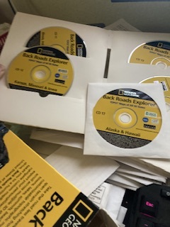
A while back there was software from National Geographic called Topo!. It was very useful way to quickly print out all pertinent maps for a days / weeks / months outing on regular home printer with some lower and/or some higher resolution pages for certain particular areas. The software was discontinued a while back, but still runs fine on modern PC's and 48 states of data are available for free on archive.org with the sole exception of the Kansas Disk Images. IE.. All other 48 states can be had for free except for Kansas. ( I don't believe there was ever a Hawaii ) Apparently it is made from unobtainium. I use the software not only for mountaineering, but also for Dual Sport Motorcycle Touring as it shows roads that existed back when topo maps were made, like from the 50's, and are still valid, legal, passable roads today. Roads that Google seemingly doesn't believe I need to know about. My request is that if anyone has a Topo! Kansas set, either post it to archive.org as CD Disk .iso files or let me know how I can buy it via PM so I can post it. If posting to archive.org, only Disks 2 through x need to be uploaded to preserve your serial number of the Disk 1 Program Disk. Go to archive.org and search for national topo to see what has been uploaded so far. Thanks in advance for any help. PM me if any help is needed in how to upload to archive.org or how to create .iso files from CD's, etc |
|
|
You might want to check out CalTopo or one of the many similar web-based platforms out there. CalTopo is free and gives you access to its own modern-looking topo maps, scanned topos, USFS topos, imagery, and several other options. You can add waypoints, create routes, and export PDFs of the maps for printing. They have topo maps for the entire US and most of the world. |
|
|
David Pneumanwrote: Have you looked at the USGS Historical Topographic Map Explorer at https://livingatlas.arcgis.com/topoexplorer/index.html? This allows you to select specific topo map editions, compare them to a modern digital map, and download them as high-quality scanned images – all for free with no ads or sign-up required. |
|
|
Yes. Good source for a couple topo maps, but the problem is no drilling down between levels and the huge filesize. Topo! has 7.5, 100K, 500k and 2 levels of state road maps for every state in the US including Alaska ( - Kansas ) and the data files are 100GB for the whole US. In contrast, just 1 state of just 7.5 maps from USGS is 50GB in itself. Extrapolating that out, 3 levels per state is 150GB X 50 states = 7.5 TB. Topo is standalone and requires no internet, so works when out of cell range, and it is free from archive.org |
|
|
I had Topo! for the Adirondacks and for Utah. Nothing has ever been thrown out that works the same way, at least not in my experience. Wish I could help you with Kansas, but alas, I don't have that one. |
|
|
Sorry, only have cali, co, ut, nm, and maybe wy…
|
|
|
TOPO is good because the data is all on your computer which is nice when you don't have internet data access. TOPO will also interface with a gps dongle on your laptop. Caltopo is great if you have a data connection. Backcountry navigator app allows you to download topo map data for a selected area and store it on your phone. Backcountry navigator is good but the menu interface is often confusing and hard to navigate. |
|
|
Greg Steelewrote: |
|
|
Ha. A good possibility. It's a little suspicious that others similar like Nebraska, Iowa, Oklahoma, etc are all grouped with other like states while Kansas alone is missing. Kansas is the most featureless state for sure. I do like it to find all the different access routes into conservation areas, etc. for great off the radar camping areas on the motorcycle beyond the obvious hiking and Mountaineering use and Kansas is on the way a lot of times one way or the other. |
|
|
I think once you get comfortable using CalTopo, it should suit your needs pretty well. |
|
|
Dan Merrickwrote: It’s also great without a data connection, but I think you need to pay for the subscription. Personally, I find it incredibly worth it for trip planning and recon for any backcountry trip. |
|
|
peterfoggwrote: A lot of CalTopo functionality is available in the free version. Although I highly recommend the modest $20 annual subscription for their base level, to support the small team of developers that makes this great tool available. |
|
|
 I'll try to see about putting this up next week |
|
|
Anyone have a serial number for the California series? I have the original disks, but the packaging is damaged. I need to get a serial number to allow me to load the software on a new laptop without having to carry a CD reader with me. |

|
derek kooncewrote: Hit up the company who made the software and ask for help/serial. |
|
|
I know this dated, but I have the serial number of Topo! California if you still want it. I am not sure it will work for your CD, I also have the the last update to the software I think it is ver 4.5. How do I add additional states? Do I need the serial number of that CD set? |


