
 Continue with onX Maps
 Sign in with Facebook


Grand Teton FKT-ers (when the OS is icy)


|
|
I would never cut a switchback |
|
|
SirTobyThe3rd Mwrote: First off, I said it "appeared" that he cut the trail, not that he did. I'm not "making it up for no good reason", nor spreading "false rumors". Secondly, all you need to do is look is his GPS track. It certainly appears like he cut the trail by Spalding Falls. His GPS track lines up with the trail until he hits those switchbacks. Zoom in and take a look. Maybe his GPS malfunctioned at the switchbacks going up & down. It's where Kilian apparently cut the trail, too. In any case, he can answer for his GPS track. I feel it’s important to not to trust what anyone says when it might involve illegal activity. Sunseri, Kilian Jornet, Emelie Forsberg, and Jen Day Denton have all had their Grand Teton FKT's rejected (flagged). Jack's page: 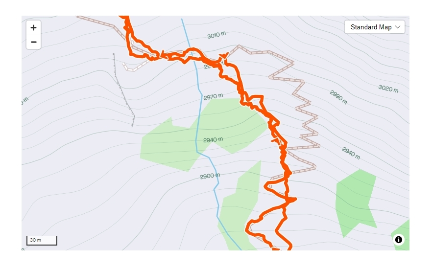 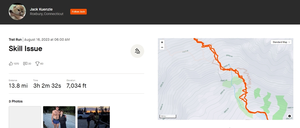 |
|
|
Wind Riverwrote: It’s easy to get off the proper trail by Spaulding falls. Lots of social side trails there. Anyway carry on |
|
|
Jabroni McChuffersonwrote: Thanks for chiming in Jabroni. I'll disagree if we're referring to the switchbacks leading to the top of the falls. There's only one trail to the top of Spalding Falls (Spaulding is spelling error btw). Any "trails" you see are erosion from climbers taking shortcuts. There are no social side trails where the GPS track is shown to reach the top of the falls. "Social trails" are usually located where there are no trails to your destination. It is easy to stay on the proper trail and people should. Going off trail by the falls is likely to cause rockfall, erosion and damage vegetation. |
|
|
Wind Riverwrote: Ok. Isn’t that cave bivy near there? Maybe I’m think of a different section |
|
|
NateB wrote: Andy Anderson was asked about short-cutting on the Grand Teton. Here's the interview: Q: You stayed on the defined trail where it exists, we hear. There’s been some hype about shortcuts. Did you do any shortcutting, anywhere? A: I did stay on the trail. I think it is actually faster for me. Even though shortcuts may save a little distance, they probably don’t save me any time, because I just cannot run that fast on such steep downhills. On the other hand, the trails are so nice and well maintained that blasting down them as fast as you can run is great fun. Plus, people look at you funny when you are careening down a trail like a mad man. I also knew that Bryce Thatcher did not use shortcuts, nor did I in previous attempts at the three-hour mark, and the park does not like folks to use them. See https://www.irunfar.com/andy-anderson-grand-teton-and-longs-peak-round-trip-fkt-interview. |
|
|
NateB wrote: In regards to it being "illegal" vs in bad form (Leave No Trace), that's open to debate until the park service adds their voice on the law. Renny Jackson (former GTNP head climbing ranger and guidebook author) says the trail is unmaintained past the Platforms Camping Zone. The ranger who took his place, Jenny Lake District Ranger Scott Guenther, says the trail past the Meadows is unmaintained. As previously stated, laws about shortcutting may not apply to unmaintained and unmarked trails; especially ones not mapped for public use by GTNP. Other laws might apply. Generally speaking (with no authority), laws involving resource damage might apply but maybe not. It may depend upon the circumstances. For the record, the switchbacks by Spalding Falls were built under the direction of the park service, maybe a CCC crew. The switchbacks and stairs by the falls were built to protect the natural resources.
Kelly is a monster on rock and long excursions. Her woman's record for the Grand Teton's FKT at 14.8 mi, 3h 40m 25s,7,009 ft is well earned. Few can keep up with her, maybe Anna Gibson will. I saw both Kelly and Michelino on the Grand this summer. I admire their drive. And wish them well. |


|
A few weeks before this mouth masturbation event occurred I descended through the Moraine to the Meadows. At the time there was active trail work being done in the vicinity of Spalding Falls, all below the Caves. This area has always been a well defined but sometimes rough trail. Official or not, cutting the trail in this area should not be tolerated. And is poor form for someone who is sponsored by a major outdoor brand. In the 35 plus years that I have been running around between the Lower Saddle and Meadows the only area I have found to be at times nondescript is below the Moraine to above the Caves. And usually the issue is on the descent rather than the ascent. I have "missed" the trail. The switchback cutting aside, I think it is clear that the North Face entourage taking photos of the mouth masturbation event should be cited for commercial activity without a permit. A case could be made that even the sponsored person could be cited along side the entourage. At the end of the day none of the FKT nonsense means anything because it is no longer about the fun but about the mouth masturbation. |
|
|
NateB wrote: Wait what? Who? |
|
|
Allen Sandersonwrote:At the end of the day none of the FKT nonsense means anything because it is no longer about the fun but about the mouth masturbation. You can apply the same logic to simply climbing the Grand, chasing the next difficult grade, claiming a first ascent or anything difficult. Humans are social beings, they talk and when really big things go down, they get covered in media and receive more general attention, as they should. For some, big climbs/speed records are also a way to enjoy the benefits of being a professional athlete. But NF won’t pay him to run for pure joy, nor any other brand. So athletes find inspiring to them goals with those considerations in mind. I bet that guy found it to be a worthy personal journey to prepare and the day of running up and down the Grand faster than any human ever to be pretty damn fun. Some arbitrary site can ‘flag’ his accomplishment, but we all know he is the fastest human to go up and down it from the parking lot. If I was him, I’d be pretty stoked to know that. From a different angle, he was living and now we are doing all the ‘mouth masturbation.’ :/ Reading about someone dying in the ICU and getting a citation while all that is happening is not a good look for the park, in my personal opinion. As someone who works in critical care, I’m sort of shocked they would do something that cruel and I’d say it’s way more messed up than someone getting a photo of Sunseri collapsing in the parking lot without appropriate permission. But it’s their business of course to enforce their rules… |
|
|
Wind Riverwrote: My fault, I am not very familiar with the layout of the land there and thought you were making assumptions Kilian and Jack also cut through the marked grassy meadow shortcut lower on the approach. But I re-read your comment and realize it’s my error. I’m not sure if there is a smaller climbers trail they take by Spalding falls where you indicate or if it’s a gps failure, or if it’s an ‘allowed’ vs ‘not allowed’ shortcut that people going for that speed record use. Won’t speculate! I personally found it kind of easy to get off trail below the fixed line in a couple spots while trying to follow it over talus. I’m sure it wouldn’t be hard to follow if I made more trips up and down that way. |
|
|
SirTobyThe3rd Mwrote:
|
|
|
Allen,that happened in about 1982 when I lived in Jackson. Read it in the local paper. Guys off leash dog jumped into a hot spring in Yellowstone. Guy jumps in after it to rescue. gets burned over 80% of his body. Park service cited him while he was dying in the hospital. Maybe we have kinder gentler rangers now and maybe not? |
|
|
Thanks Nick. Back then there were certainly fewer LEO rangers. Now all NPS rangers are LEO. And some are carrying a firearm into the backcountry and it ain't because of bears. |
|
|
NateB wrote: On your 3rd GPS watch in 2012? Wow. I still use a regular watch (battery lasts forever). In 2012, Kilian was called out for taking shortcuts on his FKT by the park service. Andy knew this and he had an incentive to do it differently. He also ran the Grand many times while working in GTNP. He would have known the park regulations. And he would have known that most of the shortcuts save very little time. And he had more to lose if he was caught. And he wasn't doing it for the money (sponsored) if I remember correctly. He didn't need to impress anyone. But you make a good point either way. If you're going for bragging rights these days, have proof beyond a doubt or it doesn't count. |
|
|
SirTobyThe3rd Mwrote: And, one of her sponsors just dumped her.... |
|
|
Allen Sandersonwrote: Allen, All the seasonal climbing rangers in GTNP are LEOs? Maybe now they'll make more money than guys mowing lawns in Teton County. Seems like the position would be harder to fill. As to "At the time there was active trail work being done in the vicinity of Spalding Falls, all below the Caves", there's no dispute that they have done maintenance. Trees have been cut, etc. They built it in the 70s but always refused to show the trail on any map, not even on their backcountry camping map. And they have never marked the trail past the Platforms Camping Zone. And the rangers keep saying that it's unmaintained past 4.1 miles. So, it is hard for the park to argue that the climber's trail is a designated trail or walkway system per §2.1(b). They pretend the trail doesn't even exist. But yeah, there's only one trail below the waterfall for climbers headed for the lower saddle. And too many people have destroyed that area by not using it. There are other climbers' trails by the falls, like Irene's. And, as with the trails on the lower saddle's headwall, there are many different trails which have been used to avoid snow hazards above the falls, far too many. |
|
|
Wind Riverwrote: No, just the permanent rangers are required to be LEOs. Seasonal Rangers are not required to be LEOs (though they might be).
The issue are the two sections in boulders past the Platforms. They are not trails. If the NPS designated them trails then tourists would expect something walkable not a scramble. The issue is literally between a rock and a hard place. The section before/around Spalding Falls is a real trail but the boulder field is not so how can there be an official trail when it starts and ends without anything connected to it. Therein lies the issue. |
|
|
So it seems like anything after 4.1miles is a free for all unless the fkt crowd has a designated route? |
|
|
Allen Sandersonwrote: Thanks for the correction on the LEO status. That jives with all the January job postings I usually see as both LEO and non-LEO rangers are usually posted for seasonal work. For the record, there is nothing unusual about challenging trails being mapped by the Park Service. Yosemite & Yellowstone map trails with river or creek crossings that can be more challenging than Garnet Canyon's boulder field. The dangerous, permitted and well-mapped Half Dome cable trail sees over 200 rescues annually. And the trail to the lower saddle is mapped by the park service: this map shows it. But, it's not linkled to from GTNP's Backcountry Camping Routes and Zones webpage (it shows Garnet Canyon as a blank slate: no camping or trails past 4.1 miles). The camping sites are shown on the official (and privately run) recreation.gov website. Either way, my only interest in the status of the climber's trail is in regards to the laws that apply to going off trail past 4.1 miles. As for the laws regulations and policies pertaining to going off trail, or resource protection, there are many to consider:
Again, thanks for adding your thoughts. |


