
 Continue with onX Maps
 Sign in with Facebook


Wildfire response tips and rec's for climbers to keep in mind


|
|
Given the locale, season, climate trends, and this particularly ominous upcoming risk factor cavalcade for Cal and beyond, I'm thinking it's a good idea to gather a few pointers and best practices to broadcast for more awareness and response-ability amongst the highpoint-inclined outdoors crowd. If there's something similar already circulating, LMK! Considering a few moderately foreseeable scenarios, such as: a) you're in the high/back country and spot what appears to be a column of smoke from a recent fire start b) you're camped out on public lands and encounter some highly questionable behavior or wanton fire hazard posed by other recreationists c) you happen upon (or, Thoth forbid, cause) a surprise accident situation with fire on the ground that's spreading quickly into flammable areas d) YOLO day trip takes a turn for the worse when a nearby fire blows up and cuts off vehicular exits Thoughts, recommendations, protocols, reference material etc? Might take this to the main forum if it seems fruitful, but starting here for hopefully more focused and competent inputs first. I'll add a few notes of my own as I work on consolidating some learnings and instincts. Curious to hear good relevant anecdotes too if you got 'em. |
|
|
Have an InReach. Use it. Get reports. Know how to use navigation aids to estimate distance. NOAA weather and wind directions. Witnessing criminal behavior: clandestinely film. Cutoff from vehicle: use SOS. Know which way you can exit without getting deeper in the s..t. Know your capabilities for longer distances with minimal food. Obvious, however: 1mph for 20 hours is a good effort. Necessity is the basis for out-performance. Storm King Mountain: Drop your tools and run, your life depends on it. |
|
|
Caught twice in the mountains, once at home. Inreach and not second guessing the situation and speak up if someone in your party disagrees. Don’t be shy. Cell service, then call 911. Get the f out |
|
|
I'll add a plug for the free WatchDuty app as well if/where you can get data service, it's very comprehensive yet user friendly with the latest official and crowdsource info on active incidents. Fire behavior is reasonably predictable, but can certainly dish out consequential surprises. I think it's good to have a few basic guidelines in mind in order to make smart choices if you do end up needing to quickly work out an improvised escape plan. Stuff like how fast it can move (largely wind dependent, but in general only around walking pace or slower), how far ahead of the front it can send embers and start spot fires (a mile or less, usually much less I believe), and how smoke spreads. Getting caught up in a gnarly low-viz persistent smoke layer can shut you down quick - very disorienting and uncomfortable. Also want to echo the importance of reporting especially small/new fire ASAP wherever possible, a little faster and more targeted response time for the pros can make all the difference on preventing massively destructive blowups. Might collect a few tips on viable DIY fighting/suppression tactics too in the event of something small enough to potentially be contained on the spot, like a campground flare-up. Good reflexes help a lot!! |
|
|
If you're into back country climbing with trailheads at the dead end of 20-mile dirt roads in, etc. through drought and bark beetle stricken forest lands - best stay the hell out of there when the devils winds are blowing, as they are this week. Stay closer to the front country or make certain you have more than one viable egress, is my advice. I've never heard of climbers getting killed but I have definitely heard some close calls, very close calls, flames on the side of the only road out, close calls. And if you go anyway, maybe take a good, working chainsaw in your vehicle, and a hand saw back up. |
|
|
PCT “…fire, how to react to wildfires…” pcta.org/discover-the-trail… |
|
|
Nice…had me at “Dig a hole for your face and keep your nose in the dirt” lol. Couple other oddly worded bits of ‘advice’ and borderline misinfo in there (sorry, but it does not “move like a freight train many times faster than you can run”) but nice summary effort anyhow, They really ought to work on memeing it up and boosting awareness though, cuz second largest fire in north CA currently was just started by a PCT hikers ignoramous derriere… |
|
|
Gaia gps, besides being an absolutely stellar app, has all active wildfires in the us mapped and updated I think |
|
|
Second the notion to get an inReach and a bow saw. Also, Apple just announced non-emergency texting via satellite coming in the fall. In July of '21 We were climbing one of the Wine Spires on Washington Pass, no cell service. There was a small wildfire smoke plume to the East on the shoulder of the mountain we were climbing. It looked harmless in the morning but by afternoon it had grown, coming towards us and was not put out for a month. At our high point, we were 10 hours from the car, plenty of time to get trapped by a fire. Moral of the story is don't do long approaches in fire season. I bought my inReach the next weekend. Full story with pictures here |
|
|
From the PCT info: “If it’s windy, and you’re on a ridge or in a forest, be extra cautious. Fire can move like a freight train – many times faster than you can run. Get away as quickly as you can. Especially if you actually see flames. If a fire starts growing quickly, you won’t be able to outrun it. Fire typically moves faster uphill than it does downhill. Avoid being at the top of a ridge with a wildfire below.” Of course freight trains are pretty slow going up hill, unlike a fire. When fire is going up hill, or driven by high winds (many California fires) the speed of the advancing fire will easily out run a fleeing hotshot crew. See: Storm King, Prescott Hotshot Crew, there are more going back 100 years (a Washington State fire that killed several firefighters). If you are being overrun and do not have a deployable fire shelter, scratching a hole for your face in a desperate attempt for your second to last breath to be cooler is a rational act. |
|
|
Watch Duty app is the go to for us foothill residents to get the most up to date information on fires. If you have service in the backcountry, you can turn on notifications to alert you to nearby fires.
|
|
|
Don’t drive into the Mts when you’re low on fuel. If you are up at the end of one of our (California) forest roads and a fire starts anywhere around you must be prepared to have a wall of firefighting trucks coming towards you. They will take up all the free space on the road and only want you out of the way. Your drive “out” will take much longer than you expect, running out of fuel isn’t an option. If one wishes to read up on Fire, I recommend the book: Young Men and Fire written by Norman Maclean You’ll learn a lot. |

|
Patrick Mwrote: Plus one on the Watch Duty app. Fire just started outside of Yosemite. French Fire @ Grosjean Rd & Alta Vista Rd, Mariposa, CA - #FrenchFire https://share.watchduty.org/i/24427 |
|
|
It is obvious, but move away from major mountain fire, even if your vehicle is parked in the fire's path. 2018 Ruby Crest Trail trip. Lamoille Canyon fire, October 1. We managed to get back to out truck in 6 days. The truck (luckily) didn't burn. 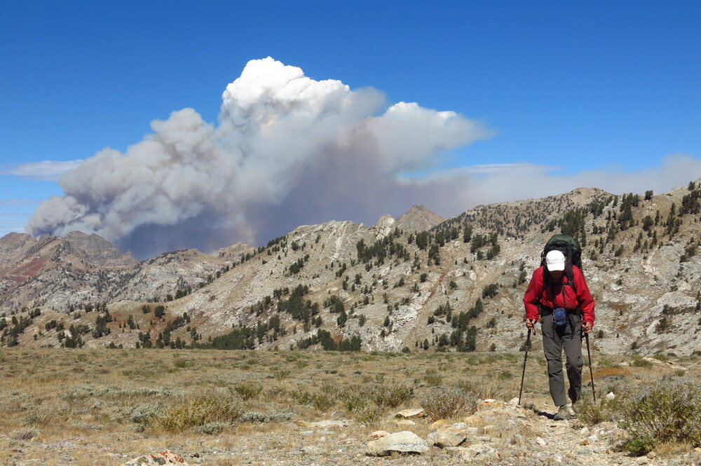 |
|
|
Another useful bookmark for trip planning and realtime evaluation is the AlertCA webcam network here: https://ops.alertcalifornia.org/cameras ...currently giving me the go ahead for a quick jaunt up in the Marble Mtn alpine tomorrow with a smallish fire about 10 miles away that's pretty well tamped down now, and no major winds forecast. YOLO it is!! |
|
|
Got to reflect a bit on sound judgment and planning with an eye on this hot spot over my shoulder, kind of like adjusting your feelers for T-storm weather in the alpine— 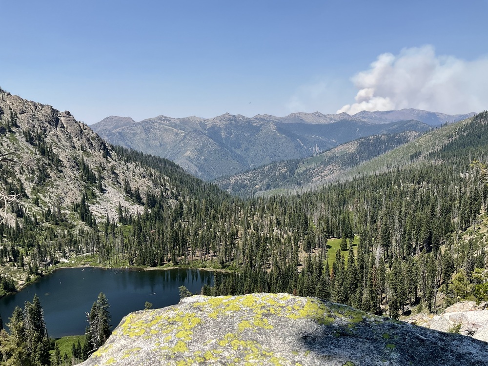 Not a pressing threat 10 miles away and across two ridges with no major driving wind, but something to watch and by evening it had popped off a good sized pyrocumulus mushroom cloud, steering its own weather patterns. Fires do tend to get sleepy at night, and things looked much quieter by morning although smoke had filled the valleys. Finished my scouting loop tour without needing to adjust course or pace, after much needed alpine swim time, and gained a better sense or intuition about how to observe and anticipate big backcountry fires in the future…even (or especially) without live data and forecasting on the go. **throwing out one more good learning portal for wildfire behavior and suppression tactics w/CA focus: https://www.youtube.com/@TheLookout1 |

|
ben brownellwrote: I'm not sure where you're getting this, but fires can move a lot faster when we get the right combination of dry conditions and wind. The 2018 Camp Fire grew from 100'x100' to 300 acres in less than an hour. Within that time it was already spotting 5 miles ahead. "Firefighters described softball-sized rocks pelting the side of their engine." (source: https://nvlpubs.nist.gov/nistpubs/TechnicalNotes/NIST.TN.2135.pdf page 55) Page 66 shows a 37-second sequence of fire burning down what looks like a tenth of a mile of road. In those conditions--which are forecastable--probably best to stay home (assuming home isn't also in a wildfire zone). I remember standing on top of the Shangri-La crag at Shuteye in maybe 2015, watching tree after 200-year old tree burst into flame. Minutes earlier there had been just a bit of smoke in the air, and an hour earlier it was clear blue skies. Fortunately the fire was far enough away that we could drive out, but there would have been no way to outrun it. And then five years later the whole place burned, of course If the forecasted sustained hot, dry weather comes to pass, I would expect broad fire bans followed by forest closures this summer in much of CA. |
|
|
An illustrative current map from the ongoing Shelly Fire up north showing color coded daily progression for the last ten days or so since ignition. No growth greater than 2 miles per day it looks like, in pretty favorable conditions to burn albeit with heavy suppression effort ongoing as well (couple thousand people staffed on it now I believe). Really hoping it settles down soon! Pretty destructive footprint already here. 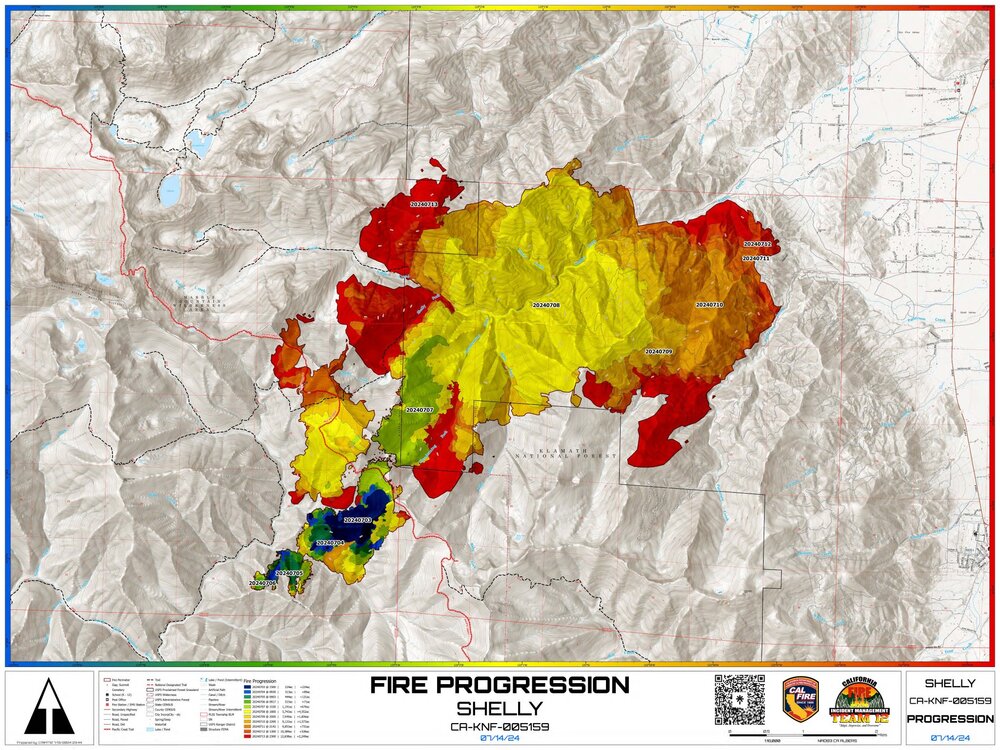 |
|
|
Another realtime case study in extreme fire behavior playing out right now: “At latest update, #ParkFire has covered >240,000 acres (~375 square miles) in <60 hours. A line from point of ignition to northernmost front currently stretches ~45 miles. Astonishing.” -Daniel Swain, weatherwest.com Crazy images out there of the nuclear-esque smoke cloud on top of this one today. All started by a local yokel torching a car and sending it off the road for a thrill. What a world of hurt. |
|
|
The news was saying it was growing at about 4000 acres per hour yesterday. Now granted, as the perimeter gets bigger, thus does the growth. So it is not like it is burning in a straight line at that rate. But Ben and others are correct, when/if the conditions are right, all you can do is run like hell. One of the reasons why the fast runs are happening (in addition to the conditions mentioned previously) is that PARK is burning through some areas with no fire history for a hundred years. So a century of fuel buildup is primed and ready to go. Then on the other flank... I feel for the poor folks at Paradise who were asked to evac again yesterday. Dang! Kick ya when you are down. And its still only July. The big stuff is still to come. |
|
|
So far it seems to have just missed the crag I've been working on for the last 5 years. I'm hoping that at least means it won't burn as hot and damage the rock/bolts.  |


