
 Continue with onX Maps
 Sign in with Facebook


CREEK SEASON (NO LONGER) CANCELLED: Highway 211 USED TO BE Closed


|
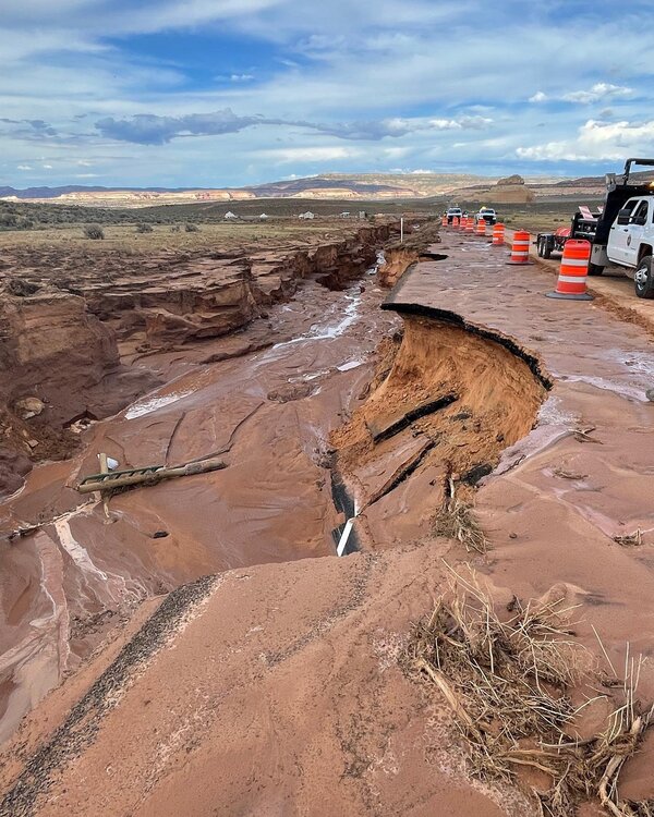 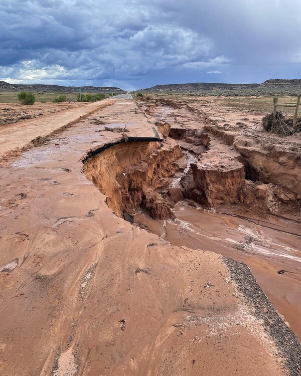 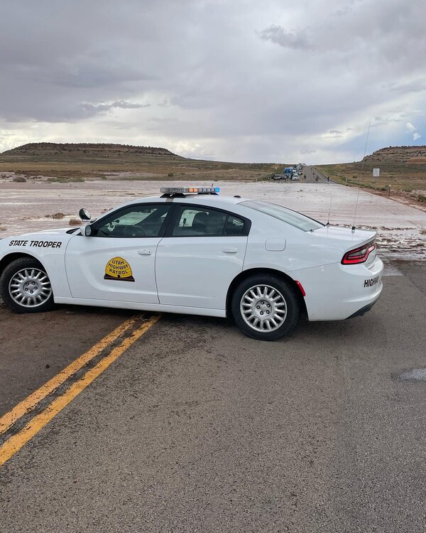 I also heard the rain turned incredible hand crack in baggy hands and rounded the edges of supercrack, oh wait that was us. Source: https://twitter.com/UTHighwayPatrol/status/1558974437436710913 |
|
|
LIVE UPDATE:  |
|
|
Ryan Never climbs wrote: No need - from the Canyonlands NP FB page: Those planning to access the Indian Creek area and the Needles District of Canyonlands should do so via Harts Draw Road. Navigate to Monticello, Utah and turn west onto 200 South at the Monticello Visitor Center. Continue on this road as it climbs up along the eastern side Abajo Mountains for approximately 18.5 miles. This road will then meet State Route 211. Turn left onto State Route 211 to access Indian Creek and Needles. You'll return the same way as you exit the area. |
|
|
Mark shhhhh, there are no other ways around this closure. In all seriousness Harts is beautiful and you wont regret cruising over there. Be warned though they do not do winter maintenance past the winter trailhead, you will be navigating steep snow covered roads once it snows this fall. Also heads up, DON'T SPEED in Monitcello, Seriously. Also Blue Mountain Foods is great, support our local businesses since you now have to use our roads to get to the creek. |
|
|
Cory Nwrote: Well, you could go from Moab on Kane Creek road to Hurrah Pass then on to the Lockhart Basin road, south through Lockhart Basin until it hits 211 just outside the park. Of course that would require all day and high clearance 4x4.... |
|
|
Close the creek and the economy between Boulder and Moab may crash! |
|
|
Alternatively from areas north you can also take county road 138 (mail station rd), it's the very next turn shortly after the needles overlook turnoff. Then after a mile or so turn left on county rd 137 (n flats rd) and follow that south for several miles and that'll dump you onto rt 211 about a mile past the 211/191 intersection. I think this will get you clear of the road damage but havent verified it yet (i dont know how far back the damage goes). Be warned this is a dirt road but should not require 4x4/high clearance, however it is slow going. |
|
|
how long could it possibly take to fix? oh wait...its UDOT. |
|
|
 Ok all joking aside, here are the real directions to go around. From the closure, turn around, go north on 191, at the intersection of 191 and I70 go east, when you see the signs for Denver you made it! Turn right and climb those sweet sweet cracks. |
|
|
YEAH BUT WHAT ABOUT CREEKSGIVING?? I NEED TO STOMP ACROSS THE DESERT WITH 500 DOGS AND EVERY GUMBY FROM DENVER |
|
|
I fail to see this as a bad thing. The creek needs a season or 30 off. |
|
|
Can we get UDOT to build a gondola from Moab to Supercrack buttress?? |
|
|
grug gwrote: Or Monorail! |
|
|
 |
|
|
grug gwrote: Won’t happen until a politician buys land at either end and expects taxpayers to pony up half a billion $ like the dumbass lcc gondola proposal. |
|
|
 Keeping it real. |
|
|
So 211 is closed between harts draw road and 191. Mail post will not get you to the creek, have to go around. |
|
|
Bolting Karenwrote: Go around which way? |
|
|
You gotta come through Monticello. |
|
|
grug gwrote: Harts draw road. Expected repair date for 211 is early November but we’ll see. Hopefully so as they don’t maintain harts draw in the winter. |
|
|
grug gwrote: Maybe if you scroll up in the thread a bit you'll find explicit directions. Or look at the Canyonlands NPS page. |


