Continue with onX Maps
 Sign in with Facebook


Short term future of Needles climbing, the straight dope...


|
|
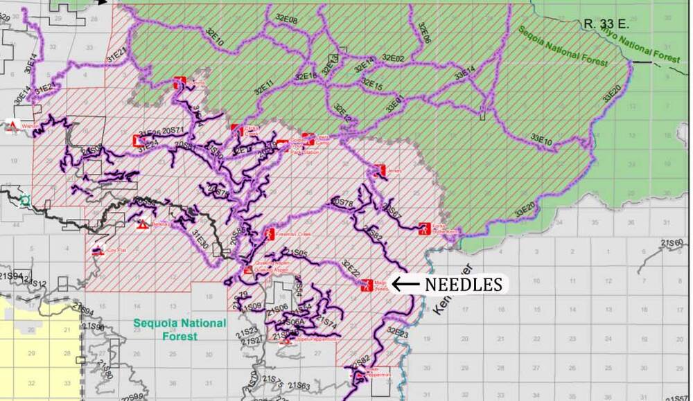
There are other threads speculating on this subject, but I don't want to bury this there. I got this from ec joe a few minutes ago... Judging by the attached map, Dome Rock is in the clear. I've heard that the Hermit took a real beating. this kind of intense direct heat can exfoliate the rock, ruining good climbs. I'm especially concerned about Mark Robinson's very fun bolted routes on the west face. We'll have to wait and see about the Needles. The notches, for the most part were not heavily forested, except at the lower features, Necromancer, the Warlock routes etc. This could be a real heartbreaker. But let's wait and see... Forest Service Closure orders. FOREST ORDER NO. 0513-21-08 SEQUOIA NATIONAL FOREST GIANT SEQUOIA NATIONAL MONUMENT WESTERN DIVIDE RANGER DISTRICT CASTLE FIRE AREA, ROADS, AND TRAILS CLOSURE Pursuant to 16 U.S.C. § 551 and 36 C.F.R. § 261.50(a) and (b), and to provide for public safety, the following acts are prohibited within the Western Divide Ranger District of the Sequoia National Forest. This Forest Order is effective from February 16, 2021, through December 31, 2021. 1. Going into or being upon National Forest System lands within the Castle Fire Closure Area, as described in Exhibit A and shown on Exhibit B. 36 C.F.R. § 261.53(e). 2. Being on the trails listed below and shown on Exhibit B. a. Any National Forest System trail within the Castle Fire Closure Area. b. Devil’s Canyon Trail (Forest Trail No. 29E16). c. Long Meadow Trail (Forest Trail No. 31E15). d. Dunn Fire Trail (Forest Trail No. 30E16). e. Doyle Trail (Forest Trail No. 30E14). 36 C.F.R. § 261.55(a). 3. Being on the roads listed below and shown on Exhibit B. a. Any National Forest System road within the Castle Fire Closure Area. b. Lloyd Meadow Road (Forest Road No. 22S82) from its intersection with Dry Meadow Road (Forest Road No. 22S53) in section 15, T.21S., R.32E. MDB&M, then north approximately 14 miles to its terminus. 36 C.F.R. § 261.54(e). Pursuant to 36 C.F.R. § 261.50(e), the following persons are exempt from this Order: 1. Any Federal, State, or local officer, or member of an organized rescue or fire fighting force in the performance of an official duty. 2. Persons with Forest Service Permit No. FS-7700-48 (Permit for Use of Roads, Trails, or Areas Restricted by Regulation or Order), specifically exempting them from this Order. 3. Owners or lessees of private land within the area to the extent necessary to access their land. 4. Residents within the area to the extent necessary to access their residences. A violation of these prohibitions is punishable by a fine of not more than $5,000 for an individual or $10,000 for an organization, or imprisonment for not more than six months, or both. 16 U.S.C. § 551 and 18 U.S.C. §§ 3559, 3571, and 3581. Executed in Porterville, California, this 11th day of February, 2021. TERESA BENSON Forest Supervisor Sequoia National Forest Here's the fire damage sat map. You can see Dome (no fire), but the Needles and Hermit are all well inside the fire zone. |

|
Thanks, Kris. I’m hoping we can use this thread for updates from the USFS and on the state of the rock going forward. The Needles is really a magical place and it totally captivated me when I visited. Sadly, hadn’t really learned how to climb cracks at that point. I can’t wait to get back there and see how or if I’ve improved! I understand heat’s effects on rock exfoliation and potentially destroying faces. The Needles is known for its incredible cracks—do we have any good insight as to how this kind of heat affects cracks? I’m sure it can’t be good, but maybe it’s not as bad as the faces? |
|
|
Sorry if my choice of words was off the mark. I've had more than a few conversations with rangers up there who, it turned out, were blowing smoke. I thought it might be useful to post the hard paper docs. And there is no doubt that the area will be off limits until the climbing season of 2022. Hopefully the personnel working out there can clear out all of the "widowmaker," dead trees and navigate the slides and so forth injury free. |
|
|
Is there any organization doing trail work regularly up there ? The Los Padres has the LPFA (<-- link). They provide the chance for regular grunts to help licensed sawyers with trail work. Just wondering if there's anything like that in the Needles area |
|
|
jt newgardwrote: That LPFA group looks great. No, there is no such group supporting the Needles. The last significant action involving climbers and the Forest Service was probably when the Access Fund and the NFS collaborated to install a real pit toilet at the trailhead camping. This was essential, and a success. So far as trail work is concerned, once the dead and dangerous trees are set to rest, the trail as it was will be fine. Yes, as you go around the north side of Magician (the old lookout site) the route gets rugged and there are at least two way to go. I think it would be a bummer to modernize that part of the approach. While the Needles is hardly a back-country area, it is an adventurous one, so if the last part of the approach is a little rough that just adds to the experience. I mean no criticism of LPFA or any other groups such as them. But they are working in an area facing very different challenges. |
|
|
Cool thanks Kristian for the info. and perspective ! I completely agree about the adventurous feel of the approach to main notch. Just adds a little extra to the experience and keeps the chuffers at bay. The main issue in the Los Padres was simply overgrown trails. A lot of hacking around with a machete but occasionally I'd get to use the big saw to move trees off the trails ..... yes it was ultra fun. I have no idea what the Needles looks like but I was picturing forest service crews that could use some grunt labor to expedite things. And I wouldn't be 100% certain the trail as it was will be fine once the trees are cleared. Once the vegetation is gone mass wasting events a higher probability. Fire also makes soil hydrophobic so when it rains the surface wants to slough off in a planar failure. The first climbers headed out to main notch will have to be real careful ! |
|
|
Thanks for all the great information; it will be quite sobering to see all the damage to the surrounding landscape... Some armchair geology: I'm quite skeptical that there will be any major effect on the actual rock, with perhaps the exception of some flakes which were directly in the fire (i.e. close to the ground in forested areas). Lots of wild fires have swept through the region over the past millennium and the rock still stands. It is quite the extreme amount of heat necessary to fracture granite, and granite has a fairly high thermal conductivity so the heat-sink of the dome will help limit large temperature gradients that can cause fractures. Also, I imagine the Needles is subject to lots of freeze-thaw cycles which would roughly mimic the types of stress rocks in fire would be subject to, so most of the susceptible features would have already popped off. Here is an interesting paper discussing granitic spalling in Southern California: core.ac.uk/download/pdf/193… |
|
|
Drew Alldredge wrote: There is plenty of great climbing around, so this isn't really accurate. Best to respect the closures and head somewhere else while the area gets cleaned up |
|
|
Thanks for the post up, Kris. It’s such a beautiful area. Glad I spent time there before this recent fire. Only time will tell. |
|
|
Has there been any update here? In theory people are allowed to start venturing out there again this year. Has anyone heard of / checked on the area? |
|
|
|

|
So closed until June 15th No new intel possibly will keep extending closure
|
|
|
|
|
|
Missing that place a lot. Only got to go once, 2019, was scared out of my mind, and started talking about the next trips the moment we left. |
|
|
Sure thing Kris. Ran into Teresa Benson earlier this year and inquired about their tasking ahead. She mentioned they got a head start since we've had a mild winter with prescribed burns and dropping 'widow makers'. It's forecasted that the public might have access as early as Memorial Day weekend and as late as July 1st. I wish I had asked if they were looking for grunt volunteers/trail stewards. I'm not sure if Stewards Of The Sequoia are involved. Curious to ask them. |
|
|
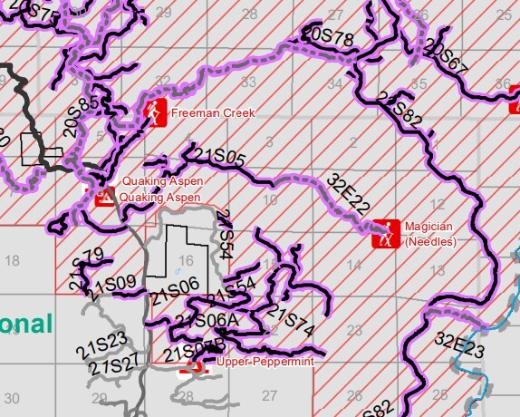
Kristian / Dave - Not sure if you are clicking the old/wrong map, or I am - but It seems the 'current' map for Forest Order 0513-21-41 that Dave linked, shows the through-June-2022 map leaving Needles Open currently. Kristian linked order 0513-21-08 which expired 12-31-2021.... (current version shows 21S05 as not in the fire-closure, though THIS: ( fs.usda.gov/Internet/FSE_DO… ) shows as a 'winter closure' (normal gate closure) - via This Forest Service page: https://www.fs.usda.gov/detail/sequoia/notices/?cid=FSEPRD539396 https://www.fs.usda.gov/Internet/FSE_DOCUMENTS/fseprd974439.pdf shows this: 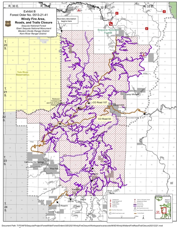 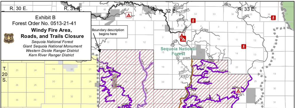
|
|
|
Colin - If you read the order I linked to, it's in effect until June 2022. And, no, you can't hike in, ride in, skip in, waltz in, etc: "...the following acts are prohibited within the Western Divide Ranger District of the Sequoia National Forest. This Forest Order is effective from November 24, 2021, through June 15, 2022. 1. Going into or being upon National Forest System lands within the Windy Fire Closure Area, as described in Exhibit A and shown on Exhibit B. 36 C.F.R. § 261.52(e). 2. Being on any National Forest System road within the Windy Fire Closure Area, as shown on Exhibit B. 36 C.F.R. § 261.54(e). 3. Being on any National Forest System trail within the Windy Fire Closure Area as shown Exhibit B. 36 C.F.R. § 261.55(a).
|
|
|
Dave - the MAP of the 'Windy Fire Closure Area' - shows 21S05 as OUTSIDE the closure area, in the version that is extended until June 2022. That's what I'm trying to point out. Not sure where you are getting the link that shows 21S05 INSIDE the closure, besides the version that Expired 12-31-2021 ... Just trying to help out here & figure it out ! |
|
|
Colin, you're right about my map. It's old. Ooops, Devil's in the details, etc. It seems odd that the older map shows the Windy Fire closure area to be mostly N of the Needles, the newer one, mostly S. |
|
|
Kristian - That was i was noticing too- was wondering if maybe it was a different ranger-district or something? ie Western Divide vs Kern? but i think it is more that- they collapsed the Windy closure map into only the southern-stuff... (ie, still illegal to drive to Voodoo Dome ) but the Normal Northern/Main entrance is open (minus winter gate closure) and 'the rest' will open June 2022. Also, I have continued to read your guidebook and build the stoke during this EXTENDED closure !!! thank you for that !! Soooo i guess I'll see you up there next weekend ?? : ) 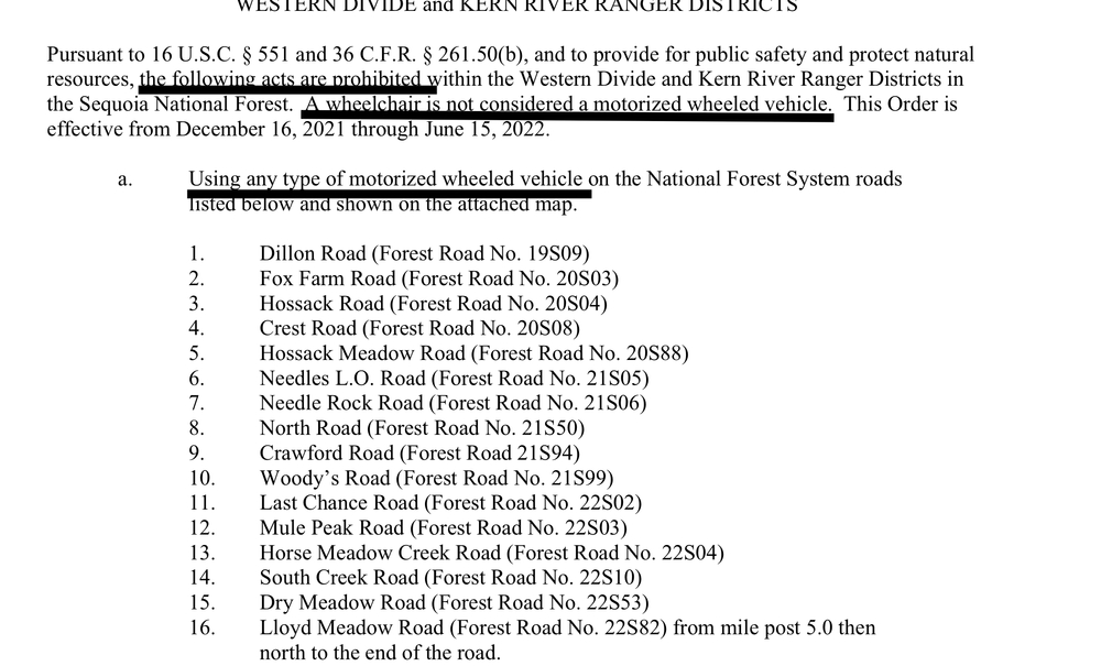 |
|
|
Sorry I wasn't able to reply yesterday. I guess I exceeded my limit in responses to the thread. After taking a closer look at what you were referencing Colin, I stand corrected. Sorry about that misunderstanding. As Kris mentioned, it seems odd that the older map shows the Windy Fire closure area up north of the Needles and the newer one mostly south. |