
 Continue with onX Maps
 Sign in with Facebook


Favorite Guidebook Features?


|
With over 15+ years of climbing, i've come across many guidebooks. Each have their own personalities, features, pros and cons. Im curious what ya'll think are some of the better guidebook features at a popular sport climbing area. Here are a few starter topics: -AM/PM Shade - Sun -Graphs breaking down grade range per area -Cliff line maps -More or less action shots -History and or profiles -Color coordinated grades (ex: 5.10 identified as yellow, 5.11 identified are red...) -Star system (3, 4 or 5) -More routes per page vs. less routes per page with more photos Cheers! |
|
|
The AM/PM shade/sun features are very nice. I have never seen the bar graph you mention, but I think it sounds like an unnecessary feature the author can skip. I love maps. Cliff line overheads, all that stuff. I also think routes should be always listed climber's left to right. I have a book that lists routes right to left for one half, and then left to right for the second half. All because there's an approach that goes to the middle of the cliff (but that's not the only approach) and it makes my brain hurt. Here's a big one for me: a really good topo photo takes priority over any action shots. But still, we all love good climbing shots. I think color coordinated grades is a waste of time. Grades can change and people can read. I also vastly prefer the +/- grading system (in general, but especially for guidebooks). A good index is also nice (a grade based index and a name based index). I love the history and profiles. It's fun to have good articles along with some of the walls/crags. Re: Peter Crofts write-ups. There are way better topos in other books, but I bought his high sierra guidebook just to read the blurbs. Star system. I think I am partial to four stars? Another thing I really like: when the guidebook includes local ethics. |
|
|
Really good overhead maps of crags with some routes indicated with trails-- this is what MP really lacks Clear descent beta Color photos Lack of ads Unabridged, complete, everything-in-the-area books Area/FA history and interviews Rounded corners and durable/waterproof cover and binding |
|
|
A geo-located app! GunksApp changed the game for me... The old gray Dick doesn't leave home often now. |
|
|
I'm a fan of curated "best of" tick lists based on climbing styles and grades, like the Index guidebook. |
|
|
Not just AM/PM sun but accounting for wind and seasonality of certain areas is key. A simple summary outlining crag recommendations for each season is good jumping off point. Coloring of the sub areas header/footer is really intuitive so I can just open the book right to where I want. Bonus points for a built in cover flap with a table of contents. Another index on top of the alphabetical. By grade and then by stars, maybe with trad/mixed in red text, is the best and it really should be in all books. One more luxurious perk that I like, if there's a photo of the route put the page number the route is on in the caption. Look up the climb in the Index? Ain't nobody got time for that! |
|
|
GPS coordinates. This is the 21st century and you're trying to convey location information. Pages in a binder. I generally cut out the pages I want for a day, even cragging. Then shove them back in the book. Less weight, less wear/water on the pages not in use, but doesn't look great on the bookshelf. A binder would fix that. |
|
|
I like when the front cover extends into a flap that can be used as a bookmark. |
|
|
I always wish for an appendix of FA's and years - am I looking at a trad-bolted 60's climb that's gonna kick my ass, or a rap-bolted 90's sport route that's allergic to runouts? |
|
|
- Good pictures of climbers on moderate routes. Many books have awesome photos of climbers on hard routes, but easy and moderate climbers need inspiration too! (Newest Yosemite Valley guidebook does this well.) - As many others have said, sun/shade for different walls or climbs is crucial, as well as elevation and maybe seasonal average temps/weather in a section at the front - GPS coordinates in lat/long or UTM. - History sections - important and interesting - Detailed and descriptive photo topos (Geir Hundall’s Cochise book has the best overlay topos I have seen). - Written descriptions including approaches and descents, along with overlay maps for approach and descent. |
|
|
anchor info is always helpful... also, if a climb requires a 70m or longer rope, that should be included in the route info. |
|
|
AM/PM sun definitely useful An index of climbs listed by grade, with star rating and safety. I like the summary bar chart of grades, it allows me to quickly see whether a crag has things I want to climb or not. If it's an area with both sport and trad, then color coding on the topo by sport/trad rather than by grade is helpful. Photos and detailed description of the approaches and parking. |
|
|
I like how the red river book has boulders as green, sport as blue, and trad as red. Color for grade isn't as important as type |
|
|
Instead of just listing the desired info at the beginning of each sector, A chart that list all that info for all the different areas on one page makes it easy to choose where to climb for the day. 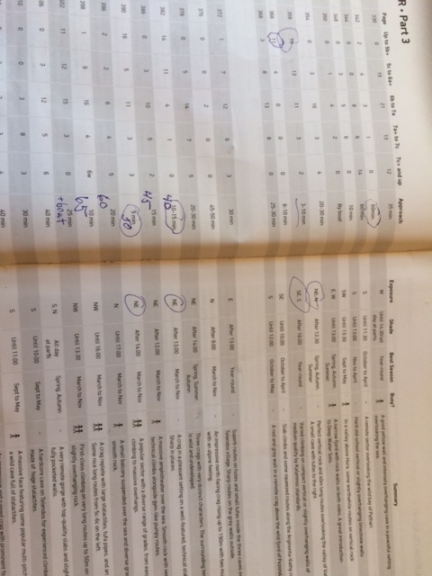 |
|
|
Maybe it's a PNW thing but in addition to the aspect and sun/shade indicators, the Snoqualmie Rock book also labels most crags/walls as drying fast/average/slow (factoring in sun, wind, seepage, etc). Hugely helpful in a place where the sun pretends it doesn't exist. ETA: I've also seen abridged forms of this in e.g. New River Rock where it recommends best places to go during and after a rain, but when it's only done for a handful of areas it has less utility and can cause crowds. |
|
|
I like a page that lists out the trad climbs . The new clear creek guide doesn’t. Oh and Given the high prices of full color guidebooks, I felt once I buy the book it will come with a complimentary half day guide! |
|
|
I'll second what Frank said, I love the flaps on the front and back covers like the Creek Freak and Pine Creek books have. Makes it super easy to mark the crag you're at for the day instead of wasting a bunch of time flipping through constantly. |
|
|
section with recommended crags: for bugs, light rain, downpour, cold, heat, camping, canoe approach, views, remoteness, etc i like a graph of number of climbs by grade length of pitch / descent i have one book that illustrates where the poison ivy is, which is most of the cliff! heh |
|
|
cliff line overhead maps. then i can figure out the sun/shade on a much more accurate level depending on time of year. |
|
|
I like how the Yosemite Supertopo book has a little chart of how hard each pitch is on a multipitch, so you can see at a glance if its sustained or not. I also like how they mention if its possible to pull through the crux(es) on gear or not, very helpful to know if you are pushing your limits. |
|
|
Matt Schilowitzwrote: +1 for Geir having the best topos. |


