
 Continue with onX Maps
 Sign in with Facebook


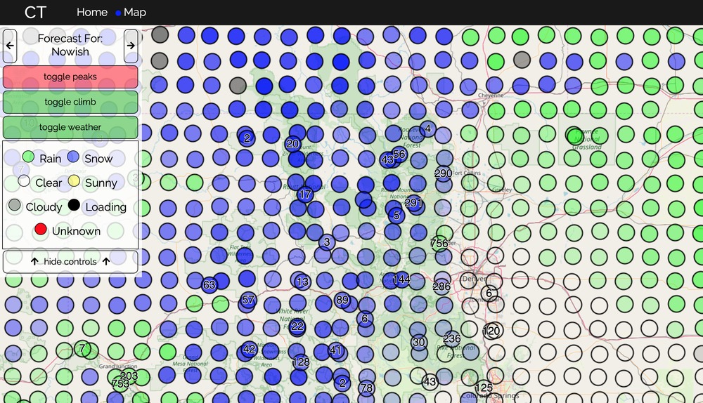
"Where will the weather be good enough to climb this weekend?"


|
Hey all, I made a tool for myself last week and though it might be useful to others. |
|
|
David James wrote: Hey all, I made a tool for myself last week and though it might be useful to others. So basically you riffed on http://climbingweather.com/ |
|
|
 I like this function. |
|
|
Marc801 C wrote: Well not exactly... I honestly didn't know that existed until one of my friends said the same. I think the functionality of walking through time on the map and having a direct beta overlay is unique enough. |
|
|
Have you given thought to adding a "wind" status for crags? Always good to avoid sustained 25mph winds at Josh. |
|
|
Sean Post wrote: Have you given thought to adding a "wind" status for crags? Always good to avoid sustained 25mph winds at Josh. Thats a fantastic idea, I do have all the wind data downloading every day anyway. Any thoughts on ways to display it on the map? I suppose changing the dots to arrows, or a toggle to change the dots to arrows (in wind direction, scaled by speed). |
|
|
Traditional weather display is "flags" off of the circle. Small line for <5mph, a small tick off the line for 5mph, large tick for 10mph, etc. See https://www.wunderground.com/wundermap for an example of what I mean. I think a toggle to show wind (or not) is good; wouldn't want to clutter it up if it wasn't a concern for someone. |
|
|
Paul Bishop wrote: Traditional weather display is "flags" off of the circle. Small line for <5mph, a small tick off the line for 5mph, large tick for 10mph, etc. See https://www.wunderground.com/wundermap for an example of what I mean. I think a toggle to show wind (or not) is good; wouldn't want to clutter it up if it wasn't a concern for someone. That's a killer example. I'll for sure implement it like that. Thanks! |
|
|
Sweet concept. I’m not sure what data you have populating the climbing areas but the Washington ones seem a little off. The names of closest peaks are correct, but there either isn’t climbing there, or a much better suggestion for that area would make sense. |
|
|
Dan Cooksey wrote: Sweet concept. I’m not sure what data you have populating the climbing areas but the Washington ones seem a little off. The names of closest peaks are correct, but there either isn’t climbing there, or a much better suggestion for that area would make sense. I think you're looking at the Summit Post beta checkout the MP tab on the beta popup, I just checked out Marymoor And saw the correct areas populating (Originally from the area and miss the weird man made crags). |
|
|
wow, this is pretty sweet. thanks for making it! |
|
|
YES MAN! Been wishing for something like this for a while, living in an area where 3-4 hour drives on weekends opens up a ton of options. Thank you!!! |
|
|
Nothing updates for me... I can see/pan/zoom the map, but there's no data overlaid, and the toggle buttons don't change anything on the map. I'm using Google Chrome in Windows 7. |
|
|
Andrew Krajnik wrote: Nothing updates for me... I can see/pan/zoom the map, but there's no data overlaid, and the toggle buttons don't change anything on the map. I'm using Google Chrome in Windows 7. Huh, that's odd, I tested on Windows 7 and 10. Could be a few things: 1) make sure you're looking at the West US specifically CO to the Pacific. |
|
|
Marc801 C wrote: This is always the response of the jealous ;) |
|
|
David James wrote: Perhaps use little arrows to indicate wind direction, such as what Google weather does, and then color the arrows in accordance with wind speed (e.g. red = lots of wind, light blue = breeze) |
|
|
Marc801 C wrote: How can you even compare this to climbingweather.com? Far better in many ways, including specific climbing areas shown with MP route listing pop-ups. |
|
|
Phil Lauffen wrote: I'm using api.weather.gov to get all the weather data right now. (Its free which was a huge draw for me). It would be super cool to incorporate other areas of the world, but downloading and normalizing all the data every day would take hours to run. |


