
 Continue with onX Maps
 Sign in with Facebook


Red Letter Day Boulder Area Climbing
Routes in Red Letter Day Boulder Area

|
Blueberry V5-6 6C+ |
|
|
Feral Cats V4 6B |
|
|
Red Letter Day V10 7C+ |
|
|
Red Letter Day Low V11 8A PG13 |
| Elevation: | 5,784 ft | 1,763 m |
| GPS: |
40.56839, -111.76858 Google Map · Climbing Area Map |
|
| Page Views: | 2,034 total · 36/month | |
| Shared By: | Eric Zschiesche on Sep 13, 2021 | |
| Admins: | Drew B, Perin Blanchard, GRK, David Crane, Nathan Fisher |
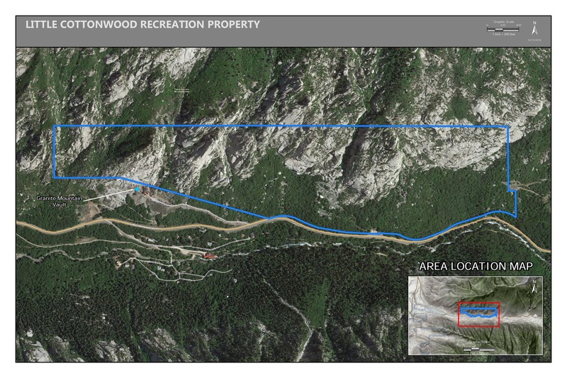
 Access Issue: Gate Buttress Area Recreational Lease: Climbs on Church Buttress above vault remain closed
Details
Access Issue: Gate Buttress Area Recreational Lease: Climbs on Church Buttress above vault remain closed
Details
June 1st, 2017:The Salt Lake Climbers Alliance (SLCA), the Church of Jesus Christ of Latter-day Saints (LDS Church), and Access Fund announce the signing of an unprecedented lease for 140 acres in Little Cottonwood Canyon (LCC). The parcel, known as the Gate Buttress, is about one mile up LCC canyon and has been popular with generations of climbers because of its world-class granite.
The agreement secures legitimate access to approximately 588 routes and 138 boulder problems at the Gate Buttress for rock climbers, who will be active stewards of the property. The recreational lease is the result of several years of negotiations between LDS Church leaders and the local climbing community.
Access Note: The climbs on the Church Buttress above the vault as well as the Glen boulders that have been traditionally closed will remain closed.
Please help us steward this area and leave no trace.
Read More:
saltlakeclimbers.org/climbe…
Description

A 10 meter high boulder, just below the large boulders containing the route Trench Warfare. Problem(s) located on the North aspect of boulder.
Getting There
Park at Quarry Parking area at the mouth of Little Cottonwood Canyon. Hike East out of parking area on dirt trail for @ 180 meters. Take a right (South) just before a concrete building (also on the right side of trail), then hike (tending slightly left / East) down to, and across Little Cottonwood Creek. On the South side bank of creek, locate West - East running trail,.. take a left / East, and hike for @ 250 meters to a 2 meter deep ravine, with a slender wooden foot bridge crossing it. Cross bridge, then go left / Northeast,.. hike for @ 100 meters, until the trail T-intersects with a North - South running trail. Turn right / South and hike (tending right) for @ 40 meters, at this point the trail will begin it's uphill climb. Hike uphill for @ 250 meters (look for occasional cairns) to a large configuration of multiple boulders (the OW Trench Warfare is located here). Red Letter Day Boulder is just at the lower down slope of the boulders, it is a North facing problem. Refer to GPS location. Cheers !
Weather Averages
|
High
|
Low
|
|
Precip
|
Days w Precip
|
| J | F | M | A | M | J | J | A | S | O | N | D |
| J | F | M | A | M | J | J | A | S | O | N | D |
Photos


All Photos Within Red Letter Day Boulder Area
Most Popular · Newest · RandomMore About Red Letter Day Boulder Area
Printer-FriendlyWhat's New


0 Comments