Broverhang Rock Climbing
| Elevation: | 7,134 ft | 2,174 m |
| GPS: |
39.73813, -105.41644 Google Map · Climbing Area Map |
|
| Page Views: | 3,658 total · 84/month | |
| Shared By: | Shirtless Mike on May 16, 2021 | |
| Admins: | Leo Paik, John McNamee, Frances Fierst, Monty, Monomaniac, Tyler KC |
 Access Issue: Seasonal Raptor Closures
Details
Raptor Closures Effective February 1-July 31
Visit: jeffco.us/open-space/news/2…
Tunnel 1 closure
For more details visit: jeffco.us/open-space/alerts…
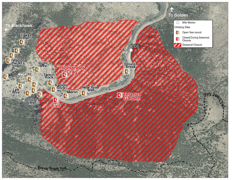
The two areas Jefferson County Open Space intends to close in Clear Creek Canyon, shown on the attached maps, encompass the active eagle nests. If the Clear Creek eagles continue to nest in the active nests, these areas will remain closed from February 1 through July 31. If the eagles choose different nesting sites, the closures will be adjusted accordingly to protect those eagles during their breeding season.
Currently, rock climbing areas that fall inside of the seasonal raptor closures include:
Blonde Formation
Bumbling Stock
Evil Area
Ghost Crag
Highlander
Skinny Legs
Stumbling Block
Tetanus Garden
Fault Caves
 Access Issue: Private Property - be aware & respectful
Details
Description

This newer area contains some great, steep thuggy, short cave climbs. It also contains a few moderate, although plenty challenging 5.11s to warm up on. The crag contains a total of 7 climbs, 3 5.11s and 3 5.13s, and one in process unfinished project.
The wall faces Southeast offering morning sun and afternoon shade. In May, the steep section of wall mostly stays shaded, and the belay goes into the shade around 1:30. In December get sun from about 11:15 - 1:00 when it gets blocked by the pillar off to the left.
Broverhang was developed by Matt Samet & Derek Peavey in 2017.
L->R:
A. Unfinished Project
B. Easy Operator, 5.11, 1p.
C. Controlled Chaos, 13 PG-13, 1p, 40', bolts.
D. See Cups, 5.13a , 1p, bolts.
E. Double D's, 5.13b, 1p, bolts.
FED. ??, 13- PG-13, 1p, 50', bolts.
F. Bro Bunnnzzz, 5.13a, 1p, 40', bolts.
G. Forget Me Knots, 11, 1p, 40',bolts.
H. J.A.M.P.B, 11-, 1p, 50', bolts.
Getting There

The quickest way is to wade the creek or take the ice bridge when it is in to Nomad Cave, then walk a shortways upstream. The cave will be slightly uphill from the main trail.
Alternatively park just upstream from the main Primo Wall parking by a bridge, cross the road, and follow a faint trail along the river to the wall. This approach takes about 15 minutes and involves a fair bit of scrambling, up over and down riverside cliffs.
Finally you can take the standard Tyrol approach to Primo Wall / Nomad's Cave, and continue a short distance upstream.
Classic Climbing Routes at Broverhang
Weather Averages
|
High
|
Low
|
|
Precip
|
Days w Precip
|
| J | F | M | A | M | J | J | A | S | O | N | D |
| J | F | M | A | M | J | J | A | S | O | N | D |
All Photos Within Broverhang
Most Popular · Newest · RandomMore About Broverhang
Printer-FriendlyWhat's New
Guidebooks (16)

 Continue with onX Maps
 Sign in with Facebook


0 Comments