The Talon Rock Climbing
Use onX Backcountry to explore the terrain in 3D, view recent satellite imagery, and more. Now available in onX Backcountry Mobile apps! For more information see this post.
| Elevation: | 7,200 ft | 2,195 m |
| GPS: |
39.73927, -105.34389 Google Map · Climbing Area Map |
|
| Page Views: | 4,347 total · 41/month | |
| Shared By: | Monomaniac on Mar 28, 2016 | |
| Admins: | Leo Paik, John McNamee, Frances Fierst, Monty, Monomaniac, Tyler KC |
 Access Issue: Seasonal Raptor Closures
Details
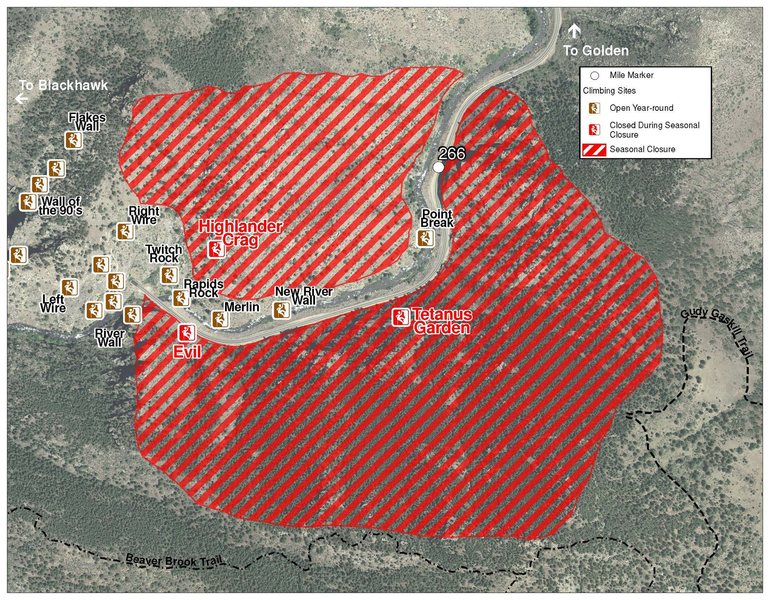
Please be aware of the annual raptor seasonal closures!
Raptor Closures Effective February 1-July 31
Visit: jeffco.us/open-space/news/2…
Tunnel 1 closure
For more details visit: jeffco.us/open-space/alerts…
The two areas Jefferson County Open Space intends to close in Clear Creek Canyon, shown on the attached maps, encompass the active eagle nests. If the Clear Creek eagles continue to nest in the active nests, these areas will remain closed from February 1 through July 31. If the eagles choose different nesting sites, the closures will be adjusted accordingly to protect those eagles during their breeding season.
Currently, rock climbing areas that fall inside of the seasonal raptor closures include:
Blonde Formation
Bumbling Stock
Evil Area
Ghost Crag
Highlander
Skinny Legs
Stumbling Block
Tetanus Garden
Fault Caves
Description

High on the south side of Clear Creek Canyon juts an arching finger of bullet metamorphic stone. The partially detached mini-tower teeters to the north and west, providing two overhanging faces and three memorable climbs. The northwest prow hosts one of the better hard routes in the canyon (and perhaps the best arête climb), but all the routes here are worth doing owing to spectacular position and excellent, featured stone.
Routes L --> R:
1. Little Stephen, 11, 40’ 1p, 5B to 2BA.
2. Where Eagles Dare, 13, 35’, 1p, 4B to 2BA.
3. Let The Peacock Fly, 13-, 30’, 1p, 4B to 2BA.
Routes L --> R:
1. Little Stephen, 11, 40’ 1p, 5B to 2BA.
2. Where Eagles Dare, 13, 35’, 1p, 4B to 2BA.
3. Let The Peacock Fly, 13-, 30’, 1p, 4B to 2BA.
Getting There

Begin by crossing the river. The easiest place to cross is about 50 feet downstream of the east end of the New Economy Cliff, where the river is relatively broad and shallow. This crossing is only safe in low water. See here for current Clear Creek flow rates.
See athe pproach topo. Once across the river, head back downstream, through the woods, to the first large talus field (almost directly below the Talon). Ascend this field to near its top, then head east to the toe of the next downstream talus field. Ascend this field to its top, then pick up a faint trail near a huge pine tree. Follow this trail for about 50 feet until it emerges in a narrow gully. Head up this gully for about 200 feet, then again head east, back into the woods, switchbacking up a steep hillside to the bottom of the Talon. Traverse under the tower to the west side to reach a nice flat-ish belay ledge.
See athe pproach topo. Once across the river, head back downstream, through the woods, to the first large talus field (almost directly below the Talon). Ascend this field to near its top, then head east to the toe of the next downstream talus field. Ascend this field to its top, then pick up a faint trail near a huge pine tree. Follow this trail for about 50 feet until it emerges in a narrow gully. Head up this gully for about 200 feet, then again head east, back into the woods, switchbacking up a steep hillside to the bottom of the Talon. Traverse under the tower to the west side to reach a nice flat-ish belay ledge.
Weather Averages
|
High
|
Low
|
|
Precip
|
Days w Precip
|
Prime Climbing Season
| J | F | M | A | M | J | J | A | S | O | N | D |
| J | F | M | A | M | J | J | A | S | O | N | D |
Photos
All Photos Within The Talon
Most Popular · Newest · RandomMore About The Talon
Printer-FriendlyWhat's New
Guidebooks (16)

 Continue with onX Maps
 Sign in with Facebook


0 Comments