
 Continue with onX Maps
 Sign in with Facebook


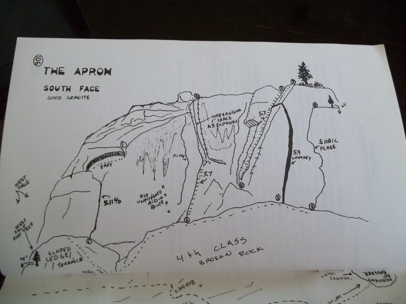
The Apron Rock Climbing
Routes in The Apron


|
"Woodthin" T 5.10c 6b 20 VII 20 E2 5b |
|
|
Dont let me down T 5.7 5a 15 V+ 13 MVS 4b A3 |
|
|
Expando Crack (Don't let me down "free") T 5.12b/c 7b+ 27 IX- 27 E6 6b |
|
|
Freezer Box T 5.9- 5c 17 VI 16 HVS 4c |
|
|
Half moon crack T 5.8+ 5b 16 VI- 15 HVS 4c |
|
|
jammin me T 5.11c/d 7a 24 VIII 25 E4 6a |
|
|
unknown T 5.9 5c 17 VI 17 HVS 5a |
|
|
unknown 5.7 T 5.7+ 5a 15 V+ 13 MVS 4b |
|
|
West wall route T 5.11a/b 6c 23 VIII- 23 E3 5c |
Order Wrong?
Sort Routes
Use onX Backcountry to explore the terrain in 3D, view recent satellite imagery, and more. Now available in onX Backcountry Mobile apps! For more information see this post.
| GPS: |
38.77584, -119.87939 Google Map · Climbing Area Map |
| Page Views: | 9,785 total · 59/month |
| Shared By: | Ron Anderson on Jul 19, 2011 |
| Admins: | Aron Quiter, Lurk Er, Mike Morley, Adam Stackhouse, Salamanizer Ski, Justin Johnsen, Vicki Schwantes |
Description

3.5 miles up hill from woodfords intersection, and .9 of a mile below the hope valley store is the Apron, a visable crag that sets 200 feet or so off the highway on the north side of the canyon. One of the first crags to see activity as it was the closest and most obvious of the roadway crags. Granite varies from grainy to excellent. Cracker cliff is just up to the north behind the apron, and the large boulder in the trees to the west is "henrys Unit" with several problems. There are a mix of trad and sport routes between cracker and the Apron.
![]()


Classic Climbing Routes at The Apron
Mountain Project's determination of the classic, most popular, highest rated climbing routes in this area.
Weather Averages
|
High
|
Low
|
|
Precip
|
Days w Precip
|
Prime Climbing Season
| J | F | M | A | M | J | J | A | S | O | N | D |
| J | F | M | A | M | J | J | A | S | O | N | D |

All Photos Within The Apron
Most Popular · Newest · RandomMore About The Apron
Printer-FriendlyWhat's New
Guidebooks (13)


0 Comments