
 Continue with onX Maps
 Sign in with Facebook


Nightworm Pinnacle Rock Climbing
Routes in Nightworm Pinnacle


|
Arety-ret Flakey Fest T 5.7 5a 15 V+ 13 MVS 4b |
|
|
Night Crawler T,TR 5.8+ 5b 16 VI- 15 HVS 4c R |
|
|
Nightingale T 5.8 5b 16 VI- 15 HVS 4c |
|
|
Unknown 11 (AKA Worm Skin) S 5.11- 6c 22 VIII- 22 E3 5c |
| Elevation: | 6,704 ft | 2,043 m |
| GPS: |
39.74161, -105.34515 Google Map · Climbing Area Map |
|
| Page Views: | 12,067 total · 58/month | |
| Shared By: | Jay Eggleston on Jun 20, 2009 | |
| Admins: | Leo Paik, John McNamee, Frances Fierst, Monty, Monomaniac, Tyler KC |
 Access Issue: Seasonal Raptor Closures
Details
Access Issue: Seasonal Raptor Closures
Details
Raptor Closures Effective February 1-July 31
Visit: jeffco.us/open-space/news/2…
Tunnel 1 closure
For more details visit: jeffco.us/open-space/alerts…

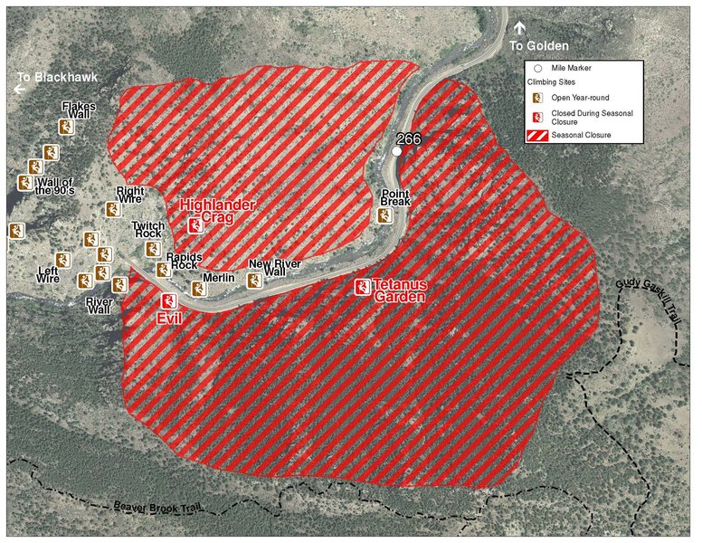
The two areas Jefferson County Open Space intends to close in Clear Creek Canyon, shown on the attached maps, encompass the active eagle nests. If the Clear Creek eagles continue to nest in the active nests, these areas will remain closed from February 1 through July 31. If the eagles choose different nesting sites, the closures will be adjusted accordingly to protect those eagles during their breeding season.
Currently, rock climbing areas that fall inside of the seasonal raptor closures include:
Blonde Formation
Bumbling Stock
Evil Area
Ghost Crag
Highlander
Skinny Legs
Stumbling Block
Tetanus Garden
Fault Caves
Description

This is a nice, little pinnacle with four routes including a perfect, easy, handcrack. The rock faces south and does get a lot of sun. It is typical Clear Creek Canyon gneiss. You probably won't see a lot of people here, but the climbing is worth a visit. You can walk off the back or walk up to set up a toprope.
Getting There
Park on the south side of the road directly across from the rock. I clocked this at 7.6 miles up the canyon. Darren Mabe calls it 8.0 miles in his excellent guidebook. Walk up the hill to the rock. This takes about 2 minutes.
The parking mentioned above no longer exists. It’s probably easiest to park down canyon to the east at the next available pullout.
L->R:

A. Arety-ret Flakey Fest, 7, 1p, 70', gear.
B. Night Crawler, 8+, 1p, 80', gear.
C. Nightingale, 8, 1p, 80', gear.
D. Unknown 11 (AKA Worm Skin), 11-, 1p, 80', bolts & pins.
Classic Climbing Routes at Nightworm Pinnacle
Weather Averages
|
High
|
Low
|
|
Precip
|
Days w Precip
|
| J | F | M | A | M | J | J | A | S | O | N | D |
| J | F | M | A | M | J | J | A | S | O | N | D |
Photos


All Photos Within Nightworm Pinnacle
Most Popular · Newest · RandomMore About Nightworm Pinnacle
Printer-FriendlyWhat's New


5 Comments