
 Continue with onX Maps
 Sign in with Facebook






Rapids Rock Rock Climbing
Routes in Rapids Rock


|
B.F.F.F. S 5.12b/c 7b+ 27 IX- 27 E6 6b |
|
|
Eddy (submitted as Unknown 5.9+), The S 5.9 5c 17 VI 17 HVS 5a |
|
|
Fleshwound S 5.11d 7a 24 VIII 25 E5 6a |
| Elevation: | 6,410 ft | 1,954 m |
| GPS: |
39.73764, -105.31775 Google Map · Climbing Area Map |
|
| Page Views: | 5,482 total · 25/month | |
| Shared By: | half-pad-mini-jug on Sep 13, 2008 | |
| Admins: | Shirtless Mike, Leo Paik, John McNamee, Frances Fierst, Monty, Monomaniac, Tyler KC |
 Access Issue: Seasonal Raptor Closures
Details
Access Issue: Seasonal Raptor Closures
Details
Raptor Closures Effective February 1-July 31
Visit: jeffco.us/open-space/news/2…
Tunnel 1 closure
For more details visit: jeffco.us/open-space/alerts…

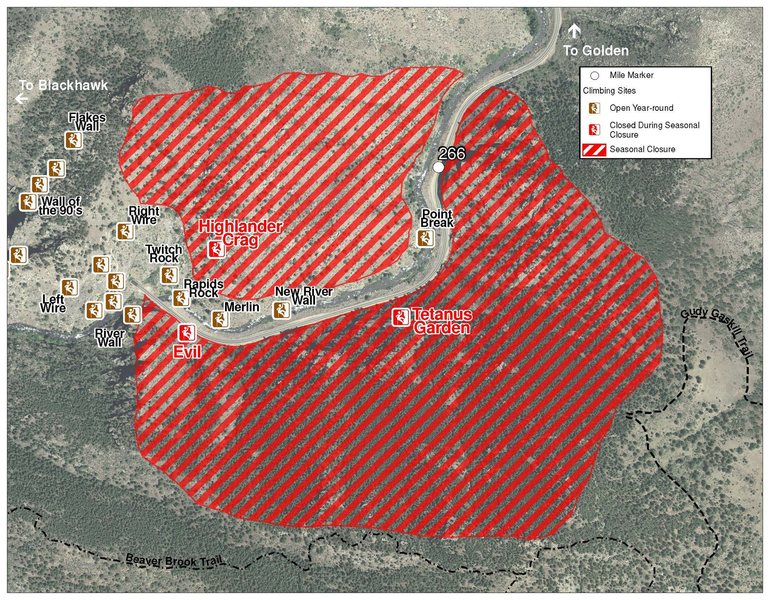
The two areas Jefferson County Open Space intends to close in Clear Creek Canyon, shown on the attached maps, encompass the active eagle nests. If the Clear Creek eagles continue to nest in the active nests, these areas will remain closed from February 1 through July 31. If the eagles choose different nesting sites, the closures will be adjusted accordingly to protect those eagles during their breeding season.
Currently, rock climbing areas that fall inside of the seasonal raptor closures include:
Blonde Formation
Bumbling Stock
Evil Area
Ghost Crag
Highlander
Skinny Legs
Stumbling Block
Tetanus Garden
Fault Caves
Description

This is the crag that sits across the river from the road, between the Merlin formation and Tunnel 2. The crag sits right on the river's edge and is identified by a fixed line across its base. Rock quality is not as nice down low, but it gets much better as you climb upwards.
Getting There
Take the New River trail and you can either rappel from the anchors at the top down to the fixed line, or continue down to Merlin and start heading back upstream on a faint trail past the tip of the big dead tree leaning on the hillside. Make your way back to the wall and scramble up and left across good ledges to some bolts at the dropoff. This is the start of the fixed line... Rappel down the small 10 foot wall to the ledge at the base of the cliff. (You either need to climb out, or ascend back up this short cliff to get out.)
L->R:

A. The Eddy (submitted as Unknown 5.9+), 9, 1p, 35', bolts.
B. B.F.F.F., 12, 1p, 50', bolts.
C. Fleshwound, 11+, 1p, 50', bolts.
 Sun Angles Details:
Weather Averages
|
High
|
Low
|
|
Precip
|
Days w Precip
|
| J | F | M | A | M | J | J | A | S | O | N | D |
| J | F | M | A | M | J | J | A | S | O | N | D |
Photos


All Photos Within Rapids Rock
Most Popular · Newest · RandomMore About Rapids Rock
Printer-FriendlyWhat's New


3 Comments