Mountain Project Logo
To save paper & ink, use the [Hide] controls next to photos and comments so you only print what you need.

Mount Goode

California > High Sierra > 08 - Bishop Pass & Ev…

Description

**13,085 ft (3,988 m)**

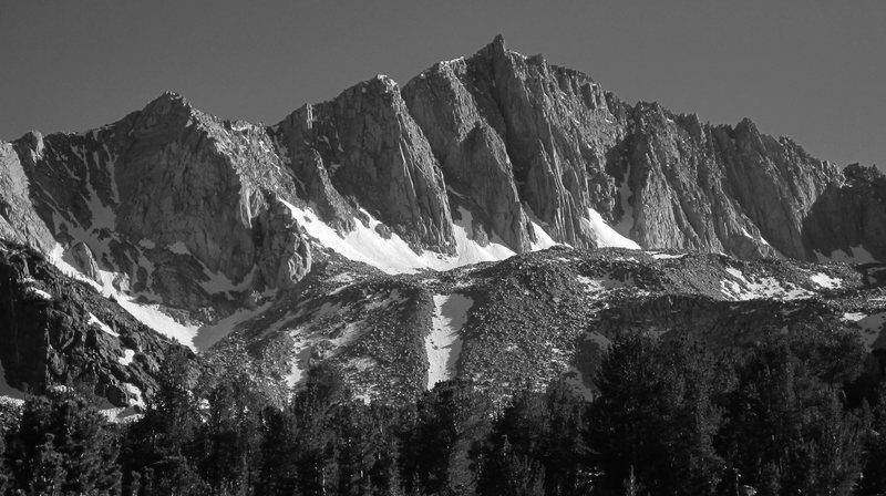
This stunning peak overlooks the south fork of the Bishop Creek drainage. The beautiful North Buttress will immediately catch a climber's eye, and a 2nd-class route up the South-East slope provides access for non-climbers as well as an easy descent route. The routes on this peak can easily be done car-to-car in a day.

Getting There

Start at the South Lake trailhead and hike toward Bishop Pass. For the easy 2nd class route to the summit, follow the trail to Bishop Lake (~ 3.5 mi), then look for use trails up the South-East slope for the 2nd class route.

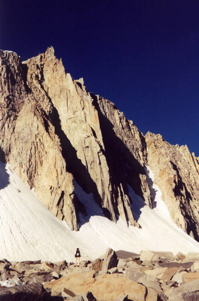
To access routes on the main north Buttress, follow the trail roughly 2.5 miles to the inlet of Long Lake, just past the lake cross the creek and head west and uphill on faint trails leading up the drainage to Margaret Lake. Do not ascend the steep nasty glacial morraine which looms above Margaret Lake directly towards Goode. Instead from the north side of the lake follow faint climber trails which contour due west and up the obvious drainage to the right of the steep nasty scree slope. Nice walking up grassy slopes and granite slabs leads up this drainage about 1 mile until the drainage peters out into steep talus to the south (towards Goode). Leave the drainage and gain the talus top to where Goode is clearly visible, continue towards Goode on talus for another 1/4 mile to the base of Mt. Goode. 4.5 miles 2500 feet of gain.

Routes from Left to Right

3rd 1- 1 I 1 M 1a Mod. Snow
 9
South East Slope
Trad, Snow, Alpine
5.4 4a 12 IV 10 VD 3c
 4
No Goode
Trad, Alpine 3 pitches
5.10a/b 6a+ 19 VI+ 19 E2 5b
 1
Jonny B. Goode
Trad, Alpine 4 pitches
5.11 6c+ 23 VIII- 23 E4 5c
 4
Goode Adventure
Trad, Alpine 5 pitches
5.10- 6a 18 VI+ 18 E1 5a
 25
Goode Earth
Trad, Alpine 6 pitches
5.10c 6b 20 VII 20 E2 5b
 1
The Goode Life
Trad, Alpine 7 pitches
5.13a 7c+ 29 IX+ 29 E6 6c
 2
The Goode, the Great, and the Ga…
Trad, Alpine 8 pitches
5.9 5c 17 VI 17 HVS 5a
 69
North Buttress
Trad, Alpine 9 pitches
5.11+ 7a 24 VIII 24 E4 6a
 10
North Buttress Variation.
Trad, Alpine 3 pitches
5.11b 6c 23 VIII- 23 E3 5c
 33
Sky Pilot
Trad, Alpine 6 pitches
5.4 4a 12 IV 10 VD 3c
 10
West Ridge
Trad, Alpine
Route Name Location Star Rating Difficulty Date
South East Slope
 9
3rd 1- 1 I 1 M 1a Mod. Snow Trad, Snow, Alpine
No Goode
 4
5.4 4a 12 IV 10 VD 3c Trad, Alpine 3 pitches
Jonny B. Goode
 1
5.10a/b 6a+ 19 VI+ 19 E2 5b Trad, Alpine 4 pitches
Goode Adventure
 4
5.11 6c+ 23 VIII- 23 E4 5c Trad, Alpine 5 pitches
Goode Earth
 25
5.10- 6a 18 VI+ 18 E1 5a Trad, Alpine 6 pitches
The Goode Life
 1
5.10c 6b 20 VII 20 E2 5b Trad, Alpine 7 pitches
The Goode, the Great, and t…
 2
5.13a 7c+ 29 IX+ 29 E6 6c Trad, Alpine 8 pitches
North Buttress
 69
5.9 5c 17 VI 17 HVS 5a Trad, Alpine 9 pitches
North Buttress Variation.
 10
5.11+ 7a 24 VIII 24 E4 6a Trad, Alpine 3 pitches
Sky Pilot
 33
5.11b 6c 23 VIII- 23 E3 5c Trad, Alpine 6 pitches
West Ridge
 10
5.4 4a 12 IV 10 VD 3c Trad, Alpine

Photos [Hide ALL Photos]

Ski tour under Mt. Goode, Sierra Nevada
[Hide Photo] Ski tour under Mt. Goode, Sierra Nevada
Mount Goode seen from Hurd Peak
[Hide Photo] Mount Goode seen from Hurd Peak
Mt. Goode, Sierras
[Hide Photo] Mt. Goode, Sierras
Mt Goode and Trapezoid Approach beta map
[Hide Photo] Mt Goode and Trapezoid Approach beta map
Mt. Goode on the right from the Bishop Pass trail
[Hide Photo] Mt. Goode on the right from the Bishop Pass trail
Mount Goode from Margret Lake - June 2014
[Hide Photo] Mount Goode from Margret Lake - June 2014
Looking right of the North Buttress
[Hide Photo] Looking right of the North Buttress
Looking left of the North Buttress
[Hide Photo] Looking left of the North Buttress
Mount Goode, North Buttress center.
[Hide Photo] Mount Goode, North Buttress center.
Tony Tennessee approaches the North Buttress.
[Hide Photo] Tony Tennessee approaches the North Buttress.
The view from the descent.
[Hide Photo] The view from the descent.
Tracy McDermott nearly to the end of the talus field on the backside descent, almost to the "sand".
[Hide Photo] Tracy McDermott nearly to the end of the talus field on the backside descent, almost to the "sand".

Comments [Hide ALL Comments]

Chris Owen
Big Bear Lake
[Hide Comment] Adam, I'm not familiar with Moraine Lake - do you mean Margaret Lake? Which is situated about 0.4 miles SW of the inlet to Long Lake. Mar 22, 2006
[Hide Comment] You're correct... my mistake. Now corrected.
Mar 27, 2006
Chris Owen
Big Bear Lake
[Hide Comment] Lots of nice campsites southwest of Long Lake towards Margaret Lake, away from the Bishop Pass crowds. Also in a good heavy snow year the cornice on the east ridge of Goode gets to be huge. Jul 2, 2014
Jon.R
Tucson, AZ
[Hide Comment] A great route to do in a day. Even in a bad snow year (like this one) and late season, some snow gear is required to safely get to the base of the north face routes. We didn't bring the proper equipment, resulting in shenanigans and some booty ~100-150 left of the start of the routes for anyone interested.

We opted for the simple hike off the backside. It may be longer than the 3rd class descent gully described in Croft's guidebook, but it is almost exclusively pleasant hiking. This is a great option if you've had enough excitement for the day. Sep 17, 2020
J V
[Hide Comment] Once the seasonal snow melts off you will need crampons and an ice axe to safely ascend to the beginning of the routes. The ice is ancient, dirty, and bullet hard. Aug 14, 2022