Home - Destinations - iPhone/Android - Gyms - Partners - Forum - Photos - Deals - What's New
 ADVANCED
Druid Stones
Patagonia Girls' Down Jacket

$139.00 30% off

$97.30

at Patagonia

39    more...
Millet Triolet 30 Backpack - 1830cu in

$139.85 29% off

$97.90

at DeptOfGoods

33    more...
Sugoi RPM Skirt - Women's

$69.99 20% off

$55.99

at AlsSports

8    more...
Gibbon Slacklines Flowline Slackline

$142.49 30% off

$99.74

at DeptOfGoods

12    more...
Wild Country - Rock Lite Helmet

$89.00 21% off

$69.97

at GearX

9    more...
Millet Triolet 30 Backpack - 1830cu in

$139.85 29% off

$97.90

at Backcountry

46    more...
 more Dirtbag Deals

Select Area...
Arch Drude Boulder 
Blood Kin Stone 
Druid Stone Area 
Kojak Boulder 
Long Ship Boulder 
Otherworld, The 
Sacrificial Boulder 
Skye Stone 
Thunder Wall Area 
Wave Boulder 

Druid Stones 


Photos: Recent | Best | Popular
Elevation: 6,200'
Lat, Long: 37.3071, -118.4364 Map
Page Views: 17,900. Good page? (1 like)   
Administrators: Aron Quiter, Euan Cameron, Adam Winters, M.Morley, Sam Vanderhyden, Tom Erickson
Submitted By: Adam Winters on Dec 16, 2007

Make this area a Favorite
What's New
 Printer View

Add Area  Add Photo  Add Comment  Add Event 


Blood Kin

Description 

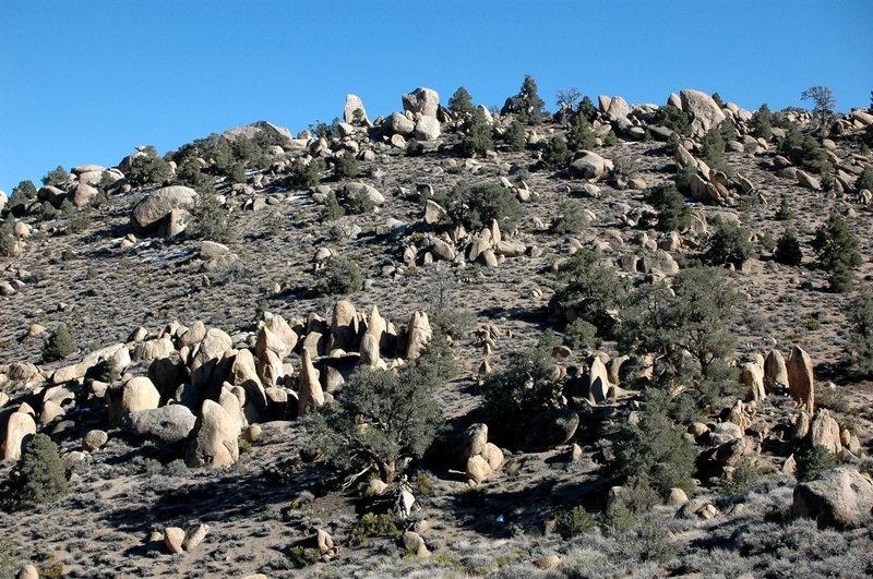
The intriguing Druid Stones sit about two thousand feet above Bishop in the foothills of the Sierras, just southwest of town. The approach is anywhere between 25 and 45 minutes up a fairly steep hillside, thus filtering out the crowds you'd see at the nearby Buttermilks or Happy Boulders, making it an ideal location on busy weekends and holidays.

Home to hundreds of boulder problems in the greater area, it's an area definitely worth checking out, with lots of potential higher on the hillside and to the south in a seemingly endless sea of granite boulders and outcroppings. Large boulders are found everywhere in the area and alongside the trail during the hike in. It'll be tempting to stop in many places and drop pad during the approach, but keep truckin' and you'll soon find a highly concentrated 'grove' of boulders with an abundance of classics surrounding the dominant and centralized Druid Stone. The rock is a coarse monzonite granite, the same as that found at the Buttermilks, so bring fresh tips and tape. Visitors will find that the view from the boulderfield alone is worth the hike, but since there are hundreds of massive granite boulders at your fingertips, you might as well have a go at some of them while you're there.


Getting There 

From US 395 (Main St. in Bishop) take W. Line St. west towards the Sierras. After a mile or so, take a left at the light onto Barlow Lane (south) and after about 1.5 miles bear right at the fork. The road curves west at this point. Make a left after you pass under the 3rd powerline onto a dirt road. Take your first right and after maybe a mile or so park at the oval where the road ends. The trailhead is here. Take the obvious trail as it goes back into the wash then switchbacks left up around the hillside. Keep hiking, after 25-45 minutes, when the trail finally flattens out on the crest, look for the boulders on your left. There is a side trail into the boulders off the main trail marked by a small rock 'V' at the fork (please use this trail).

snowy Dec day at the Druids
Submitted By: fossana on Dec 23, 2010


The Classics

Mountain Project's determination of some of the classic, most popular, highest rated routes for Druid Stones:
Jormungand   V0+ R     Boulder, 20 feet   Blood Kin Stone
There Is No Party (Right)   V1     Boulder, 15 feet   The Otherworld
You Can Cry If You Want To   V1     Boulder, 15 feet   The Otherworld
Blood Kin   V1     Boulder, 18 feet   Blood Kin Stone
Head Butt   V1     Boulder   The Otherworld
Pretty In Pink   V2     Boulder, 12 feet   The Otherworld
Thunder   V3     Boulder, 11 feet   Thunder Wall Area
Fear of the Unknown (Stand)   V3 PG13     Boulder, 17 feet   Sacrificial Boulder
Kredulf   V4     Boulder, 12 feet   Thunder Wall Area
Arch Drude   V4-5     Boulder, 18 feet   Arch Drude Boulder
Prostrate to the Higher Mind   V5-     Boulder, 12 feet   Thunder Wall Area
Fear of the Unknown (Sit)   V5 PG13     Boulder, 17 feet   Sacrificial Boulder
Hook Line and Sinker   V5     Boulder, 12 feet   Wave Boulder
Natural Philosophy   V6     Boulder, 10 feet   Thunder Wall Area
Denton's Diversion    V6     Boulder   Thunder Wall Area
Skye Dance   V6     Boulder, 18 feet   Skye Stone
Cayla   V7     Boulder, 16 feet   Skye Stone
All Fired Up   V7     Boulder, 13 feet   Thunder Wall Area
Golden Child   V9     Boulder, 15 feet   Druid Stone Area
Denton Calhoun   V11     Boulder, 20 feet   Thunder Wall Area
Browse More Classics in Druid Stones

Featured Route For Druid Stones
Rob Wulff crimps his way to the top of Kredulf

Kredulf V4  CA : Sierra Eastside : ... : Thunder Wall Area
Sit-start on edges and work straight up on crimps and edges to the jug up high, then top-out on the rounded lip. ...[more]   Browse More Classics in CA


Photos of Druid Stones Slideshow Add Photo
THE Druid Stone

THE Druid Stone

The magical and mysterious Druid Stones

The magical and mysterious Druid Stones

Looking south at the Druid Stones, visible on the ridge line.  The tall, narrow boulder is the Druid Stone proper.  The trail can be seen faintly directly under the Druid Stone.

BETA PHOTO: Looking south at the Druid Stones, visible on the ...

Jeremy Freeman bustin' it on a steep, unnamed problem

Jeremy Freeman bustin' it on a steep, unnamed prob...

Hiking out

Hiking out

Kipp Schorr at the Druid Stones

Kipp Schorr at the Druid Stones

Don't forget to look around for new stuff while you're there...

Don't forget to look around for new stuff while yo...

Wandering up the giant west face of the Merlin Block, Warlock Boulders, uphill from the Druid Stones. <br /> <br />photo: Mitch Musci

Wandering up the giant west face of the Merlin Blo...

Moon over a trailside tree

Moon over a trailside tree

Evan with some air under his feet on the west face of the Merlin Block, Warlock Boulders

Evan with some air under his feet on the west face...

The Druid Stones, on the horizon, seen from a ways up the approach trail

The Druid Stones, on the horizon, seen from a ways...

The Druid Stone and Golden Child, V9 on the left.

The Druid Stone and Golden Child, V9 on the left.

Hall of the Mountain Queens

Hall of the Mountain Queens

Jason, Brian and someone I can't remember hiking back from the Druids.

Jason, Brian and someone I can't remember hiking b...

approach trail with Basin Mtn & Mt Tom in the background

approach trail with Basin Mtn & Mt Tom in the back...

Druid Stone with ~10" of snow

Druid Stone with ~10" of snow

lovely patina

lovely patina

snowy Dec day at the Druids

snowy Dec day at the Druids


Comments on Druid Stones Add Comment
Show which comments
By adam brink
From: Boulder, CO
Apr 21, 2011

Is it too hot at the Druid Stones to boulder in summer? I've bouldered here in April and it was getting warm. Thanks!

By Adam Winters
Administrator
From: the Shire
Apr 28, 2011

It's hot for sure, and it's actually at a lower elevation than the Buttermilks. It's possible, but I'd head into the high country if I were you...

By Drrob95
Oct 27, 2011

Hi: I just want to make a comment. I know that the bouldering community has named this are the Druid Stones, but since and least the mid 1800's locals knew the area by the Paiute Word "Eganobe" (loosely translated, means place to eat-or more literal, soup house). The trail by Eganobe was for years a livestock trail, starting with horses, and then cattle, and before that a tribal trail into the area and Coyote Valley. My family was the last to take cattle up there in 1984, we drove 360 head for summer grazing in Coyote. We went the first part of July, and yes it was hot then too. My family first took livestock up the trail in 1876, the name Eganobe was told to my grandfather A.A. Brierly by Paiute cowboys that worked for him. There are many tribal home sites and arch sites just beyond Eganobe. It is too bad the bouldering community didn't learn the local name for the place that has been used for generations. I started going in with cattle when I was 12. Last time I went I was 28. Often in the summer we rode up the trail to check cattle sometimes once a week, in later years we hauled our horses up the Coyote Road to make cattle check. Right near spot Eganobe is where we would let the cattle drift after the first day of the drive, we spent the night on the trail and early next morning followed the straglers on into Coyote. Later, after the trap was built at the foot of the hill, the cattle would be put in there for the night, and the next day we drove the cattle in all the way to Coyote. I have written a couple articles in the Inyo Register about the Eganobe area. It is one of my favorite spots, and has lots of memories.