
 Continue with onX Maps
 Sign in with Facebook


GPS map tool for approaches???
|
|
Can folks share information about and recommend GPS map tools which are light, easy to read and show my position relative to paths others have shared? I see people share images that overlay on a map the paths they took on trail and off trail to reach a climb. Is there a way and tool to tap into that data to make finding backcountry climbs easier? |
|
|
You can have them upload it as an approach trail to MP and then use the MP app. Definitely not the nicest tool, but an effective way to share the track to a wide audience. |

|
+1 for Gaia GPS, especially if you do any other hiking, etc. What I've done before is select the Area Map on MP that has an approach trail, then click the trail on the map and then Full Details. You can download the GPX file from there and upload it to Gaia, or any other service/device you find. You can download the trails & maps for offline use with Gaia. If you're bringing your phone out with you anyway, it doesn't add any weight. If you're being taken out to a new spot and there re no published approach trails, record the track when you're hiking out and now you have it saved. |
|
|
Thank you Austin, MP and Will!! (Above) Thank you Mike and Mark (Below) Double Thanks Will. And thank you Webfoot. (Farther Below) |
|
|
Gaia gps. You can plot your path on the desktop app and it syncs with mobile. Or just use the mobile version |
|
|
GaiaGPS and CalTopo are both excellent mapping apps. CalTopo has a wide range of map sources and overlays, which makes it an excellent source for avoiding private property, checking sun angles, or just finding out who has jurisdiction over a given land parcel. The higher priced subscriptions in CalTopo let you save a map with a path you've drawn as a PDF, which you can print as a paper map. I've had maps printed this way in 11" x 17" format, which makes for a paper map that's as good as any you can buy. I alternate between CalTopo and GaiaGPS, depending on which one shows trails or public tracks that are more useful to me. |
|
|
Will WBwrote:
If there is not a clickable trail on MP, is it best to use Gaia as the starting data point? |
|
|
Live Perchedwrote: You can also click the text link "Climbing Area Map" next to the google maps directions link on an area's main page. Takes you to the same page. If there is no clickable trail then Gaia could be helpful still. For example, to get El Cajon Mountain, if we pretend there is not already a trail on MP, you can see that the Gaia map already has this particular approach trail on one of its maps (the first map). Sure, this is not what I usually expect but here I got lucky and it seems to happen a lot. If there is no trail included on the map, you can look to see if someone has recorded a public track. I have never been to the Mountaineer Walls at El Cajon but I could follow the public tracks (in faded green, second picture below) to get there. If there are no tracks or trails of any kind on MP or Gaia, it still has great maps that I think could be a good place to start for figuring out how out how you might get there even if you really only now the location of the climb and nothing else. In particular, their slope angle relief maps are great for seeing But usually that doesn't happen, and usually there is *some* approach beta out there. One thing I'll add is that I use the paid version of Gaia. I used the free version for a long time and it works well, but I did want access to more maps and layers. 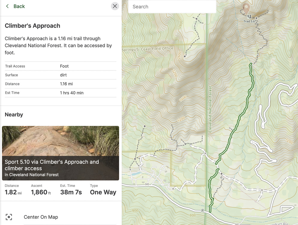 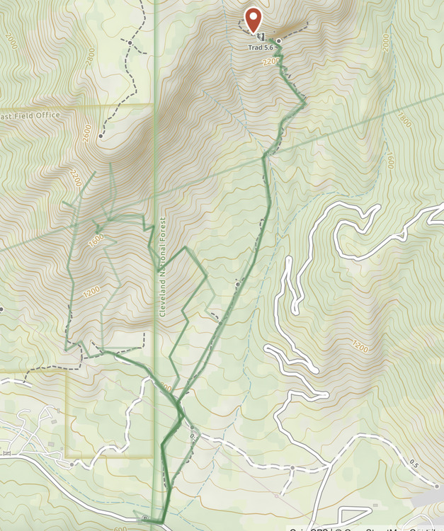 |
|
|
I use OruxMaps. It doesn't require the privacy invasion that most mapping apps do. Routes may appear on the Strava Global Heatmap. You need to create a free account to see the map in full resolution. |
|
|
Webfootwrote: What do see Orux as doing to help with privacy? I haven't heard of it before so I'm just curious and checking it out, but I like the sound of that. Looks like it's downloaded from Amazon or Google. Gaia at least has the option to keep all your tracks private, and to not share tracks and usage with Google Analytics so that's a little something I guess. Hadn't thought of the Strava Heatmaps. Good idea too. |
|
|
I used Locus Map Pro until they changed their privacy policy, and looking at others I found similar concerns buried in the TOS. OruxMaps had a shorter and simpler privacy policy than most. Gaia GPS might have a good privacy policy but it is not easy for me to tell. The Gaia GPS FAQ directs me to a generic OutsideInc page which is longer, doesn't specifically address the Gaia GPS app, and seems to have more room for ambiguity. |
|
|
Good point regarding Gaia. I kind of forgot that it was taken over by Outside Magazine. It was very much it's own thing when I started with it. Maybe it's worth my time to comb through any new ToS... Part of me figures that if I have my phone on me anyway, then there isn't too much I can do. Nice to see a simple and laid out privacy policy from Orux; too bad it's so uncommon. |

|
mark felberwrote: You can print your Caltopo map to PDF in the free version. You can use the QR code that populates on your CalTopo pdf to upload your map to Avenza for free offline route finding. This has been my go to for the last few years. |
|
|
I find that Gaia is the best for using in the field. CalTopo is the best for printing out maps. |
|
|
Former Present and Future Climber wrote: I don't think it is possible to view a single track. |


