
 Continue with onX Maps
 Sign in with Facebook


XBackcountry; useless?


|
Not Sure wrote: Hm which link isn't opening? The top nav "Limited Time 70% Off onX Backcountry" link is this one (https://www.onxmaps.com/backcountry/onx-backcountry-is-now-powered-by-mountain-project?utm_source=mountainproject&utm_medium=ap-climb-top-nav-cta&utm_campaign=lto-67-off). Pricing is listed on that page (screenshot below). 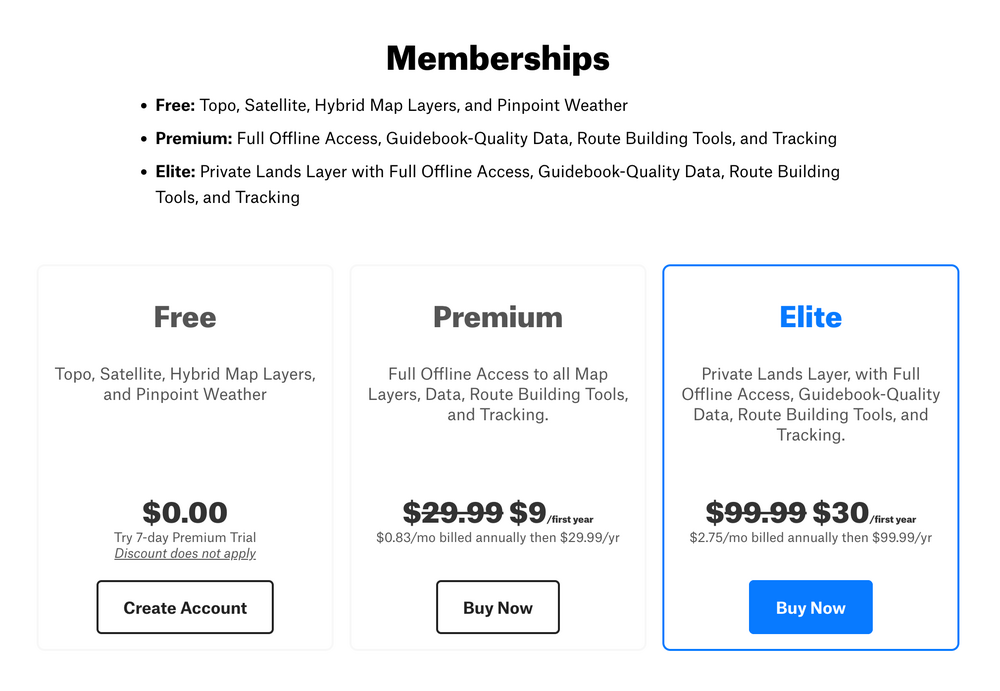 |
|
|
Just putting this here because I don't know where else to go and hoping that some admin sees it. I'm not getting XBackcountry. It's bullshit you have to have it to access some content. |
|
|
Totally fair, Adam. As a long-time MP user, you've seen the attempts at making MP financially sustainable with a decade of ads when MP first started in 2005, charging for the app in 2014, and the Dirtbag Deals after that. And the number of MP users has only gone up. As said elsewhere, but important to reiterate, onX is a legitimate outdoor planning and navigation app. Maybe not for climbing solely, but if you hike, backpack, mountain bike, or especially backcountry ski/snowboard, it's a powerful tool and it's being improved every day. The requirement to connect your MP account to onX creates a free onX account that you never have to use should you choose not to. You might get some marketing emails, which can definitely be annoying. But we hope they at least feel relevant to you as an outdoor enthusiast and I assume you can unsubscribe from them if it gets to be too much. We know the banner ads, pop-ups, and login requirement have been frustrating (and even broken at times), and we're sorry for that. We've been adjusting those based on MP community feedback and will continue to work on making it better. Send me a message if you have questions, want to vent, or have ideas for making MP better. |
|
|
For people that bought premium or elite, is it worth it? |
|
|
Not Sure wrote: I bought premium. It was worth $9. If they increase the price when my subscription is up, I'll dump it. It's useful, but not THAT useful and the competition in this market is really tight. It doesn't extensively offer more than many of its competitors so it got my business on price. |
|
|
9 a year or a month |
|
|
Hey Zander I figure this is not a bad place to voice a suggestion for the app... Is it possible to make routebuilding offline a thing? It would be super helpful for situations where one is offline using downloaded maps and is considering changing plans, looking at distances/elevation/etc. I'm pretty sure Gaia has that ability but I can't remember for sure. Otherwise OnX is very much worth the price in my opinion. |
|
|
Nick Niebuhr wrote: Hey Nate, great question. Route builder is available offline (Snap To & Point Draw) and you can get distance but not elevation yet. We're working on elevation as we speak but requires a bit of backend work with the map tiles. Screenshots below for steps to access route build tool and what that looks like. (You can test being offline by going to Offline Maps and using the Go Offline button next to the New Map button, going into Airplane mode, and relaunching the app.) 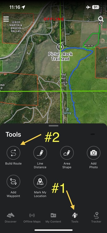 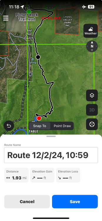 |
|
|
Zander Göpfert wrote: Sweet! Is this a new feature? Last time I tried doing it offline was at least a few months ago but probably more. |
|
|
I think it went out last spring / summer so relatively new, yeah. Keep the feedback coming! More offline tools and features are definitely something we're excited about adding and improving. |
|
|
Ok while we’re at it, any chance you’ll be expanding/improving winter sat layers? Fatmap was more detailed, and had more zones available. Particularly SW Colorado is a bit lacking… |
|
|
Definitely. I don't know what the timeline is but we've heard this quite a bit, especially with Fatmap going away. Would love to know what you liked most about Fatmap's winter imagery and/or the zones missing coverage in onX Backcountry. Though you sacrifice even more resolution, one potential workaround available to Elite users is to use the Recent Imagery layer (in mobile app > tap layers button on map > Layer Options > see Preferred Basemap Imagery > select Recent Imagery), which shows satellite imagery from the previous week. And you can access SNOTEL stations (circular snowflake icon) on the map that show hourly snow depth, temperature, and 24hr accumulation. |


