
 Continue with onX Maps
 Sign in with Facebook


Whitney condies
|
|
Looking to scrub some beta on Mt. Whitney conditions, most notably camping at Iceberg and making an attempt on the East Face + descending the Mountaineers Route. Any information is very appreciated! Thank you! |
|
|
Here is a pic from 14Aug. The route is dry. Mountaineers route has some snow so an ice axe is good to have there. We didn't use crampons but had to downclimb the snow carefully with an axe to avoid slipping. 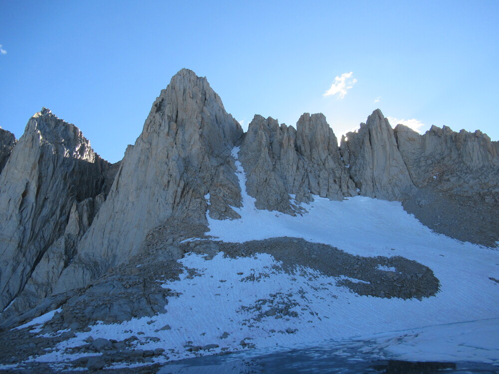 |
|
|
Camping is dry too, we hung our food from a boulder to keep the marmots off  |
|
|
Nice job, Eric. However, I am forced to use many exclamation points and caps in responding to your conditions report: AUGUST 14 WAS BEFORE HURRICANE HILARY !!!!!!!!!!!!!!!!!!!!!!!!!!!!!!!!! lol. It looks like winter up there. We climbed Fishhook Arete, so I can't comment on the mountaineer's route directly. However multiple parties were too sketched to descend the mountaineer's route, and decided to hike down the Mt Whitney trail to the Portal, bivy, then hike back up to Iceberg to retrieve their gear the following day. Parties carrying suitable equipment (good boots, crampons, and axe) appear to be having success, following a bootpack traversing from a drop-in point further west along the summit plateau sideways over to the notch. |
|
|
Hey everyone, I was up at Iceberg lake from 08/24 to 08/29. Can confirm this - no parties made it down the mountaineers route without crampons and ice axes, and many who did have those also didn't make it down. Actually, only a single party made it down the route in the 4 days I was there, and that was a guided party who was prepared for dangerous snow travel. The issue isn't the typical part of the route (the part that you can see from the lake), it's getting off the backside of Whitney to the notch. It's covered in loose snow at a steep angle, with nothing to bite into and nothing to belay off of. We saw 4 parties take the Disneyland trail down to the portal, and we climbed East Buttress on the 28th and made the same (reluctant) decision. It just wasn't safe to try. We considered going down the JMT to guitar lake, up beyond Arctic lakes, and over Whitney-Russel pass from the West, but it was late by the time we summited and it didn't seem like the right x-country trek to do in the dark. It can be done, though. Honestly, coming back up to Iceberg from the portal isn't too bad. You're acclimated and have light packs at that point. |
|
|
Would it be dumb to lug my snowboard and boots up there? Could I rip a line down the mountaineers route? Do I need full on crampons and technical picks or will micro spikes and a mountaineers axe work? What would be your recommended set-up at this time of year with these conditions?
|

|
Does anyone know the conditions going over the Whitney Russel pass from iceberg to russel approach? Is there snow and can you avoid it or would you need spikes? |
|
|
Brad, that I can speak to. Headed up to Russell is chill. There's a snow patch but it's low angle and suncupped. No snow gear needed. Nice rap station in place to land in the scree field pointing back towards the start of the routes, so you can head direct back to Iceberg (as opposed to Upper Boy Scout). As John elucidated, the mountaineer's route "condies" are weird due to the new unconsolidated snow. Austin, no you cannot rip the entire route on your board unfortunately. The lower chute below the notch is patchy. The guided parties brought boots / crampons / axes and avoided the final steep section above the notch, by traversing to the west onto the summit plateau. Wish I had a pic! |
|
|
Any update on conditions? I'm assuming the mountaineer's route hasn't changed much but would be glad to hear otherwise. Is the best way to get back to Iceberg heading south then west and looping around through the Arctic lake basin? |
|
|
Tyler Shopshirewrote: Best way back through Arctic Lakes? I mean, if you want to add a million miles to your day just to avoid walking on some snow. |
|
|
Ryan Huetterwrote: Did you read John's post above? |
|
|
Tyler Shopshirewrote: So, bring the light mtn boots, crampons and a short ax. There are plenty of features to rap off of down the final 400 if you are bringing a rope. If you're trying to climb the MR without bringing a rope then maybe choosing a non-technical descent is preferable, but that loop is long. At that point I'd rather just climb it from the car and then descend the trail. |
|
|
Climbed the East Buttress and descended MR on this past Monday. You’ll want to rap some of the MR to the notch (two tat anchors). Descending the MR with axe and strap on crampons was mellow for us (make sure to cut onto the rock on the East Butt/East face approach slopes when you can), but you could certainly encounter conditions that require rapping if things ice up— but as said before, there’s lots of spots to build anchors. |
|
|
Plenty of parties up there the last few days are epic-ing by looping back around through the Portal to camp or Arctic Lakes, just to avoid a couple hundred feet of low angle, firm but boot-packed snow. Getting benighted, slipping into Iceberg Lake, lots of "adventure" was being had. No raps needed descending skier's right side of Final 400. Crampons very helpful for the single unavoidable snowpatch between 13,500 and 13,700'. Pretty civilized. |


