
 Continue with onX Maps
 Sign in with Facebook


Clear Creek Quarry: BCC Update Inside!


|
|
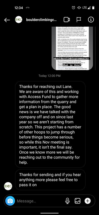
Does anyone know about this? Any validity to this post? Thoughts? 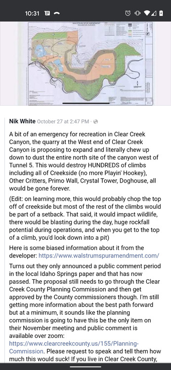 |


|
I can vouch for Nik as a community leader in the whitewater community around here. I think it's still a little up in the air as to how the climbs will be affected exactly, but it's definitely going to be a negative for recreation. |
|
|
 |
|
|
I disagree with BCC, I think this is more urgent. All of the permit amendment documents are part of the public record on the DRMS website (searching under permit # M1983033, ordering by document date). The City of Idaho Springs filed a formal complaint, so the next step is a hearing in front of the Mine Land Reclamation Board November 17-18. This is different than the hearing Nik references in his post. The board will decide whether to grant the permit amendment or not. There is the opportunity for public comment there both oral and written. More info in this recording of an informal meeting from last week |
|
|
Sarah Walkerwrote: You should reach out to the BCC if you think they are missing something and it's as urgent as you say. Sometime they rely on us as much as we might rely on them. In my experience they are very communicative. |
|
|
Thanks Lane, I sent them an email |
|
|
Sarah, thanks for the great source of information on the DRMS website. In looking through some of the documents, it looks like there are more questions than answers on how the quarry expansion will impact climbing. I think it is important to keep in mind that the quarry has generously allowed climbers to climb on the quarry's private land for decades. It is not public property. It is unclear if the quarry operations will chew up the climbing crags as claimed by the Facebook posts or not. There is a large conservation easement between the north side of the river and the quarry. In comparing maps with mountain project crag locations, it looks like the crags closest to the quarry operations would be Conspiracy Crag and Healing Center. From my rough comparison, it does not look like Primo Wall, Creekside, Other Critters, and Dog House will be chewed up by the quarry. Has anybody else done a more thorough analysis? The quarry states the conservation easement is for bighorn sheep habitat, but I did not see anything about climbing or recreation. It is unclear if climbing will be allowed on the undisturbed land of the conservation easement or not. The most obvious problem I see with the quarry is they are not mining the sides of the quarry vertical enough to climb in 10 to 20 years. |
|
|
ryan lairdwrote: Great points, thanks for your perspective Ryan. Agree, there is definitely uncertainty with impacts to recreation. We just need to help each other stay informed and participate as stakeholders in the community |
|
|
Lexi Berger wrote: Sent! |
|
|
Lexi Berger wrote: Just sent an email to him. I'll be at that meeting. |
|
|
They mention 239 acres of undisturbed buffer area around the quarry, which quite possibly includes most of the climbing areas as they reside directly over the creek and highway... Would be very hard or impossible for a quarry to get the permitting that would allow them to disturb a major waterway and a major public right-of-way... So I guess the question is will climbing still be allowed at those areas? |
|
|
T Dwrote: i noticed the same, and put a hold on passing judgment until i better understand exactly what land they are asking for in the permit and where this boundary area will exist. all of the maps i can find are too general. logically, i have a hard time believing they will destroy the cliffs on the north side of the creek, but you never know... |
|
|
As you have all seen, there is a proposal from the Albert Frei & Sons quarry to expand their operation under the Walstrum Spur Amendment. There are a number of popular climbing areas on the private property owned by the Frei family in upper Clear Creek Canyon. BCC and the Access Fund have been working with the Frei family to try and secure long term access to these climbing areas. https://www.boulderclimbers.org/news/2021/11/2/update-on-upper-clear-creek-canyon-access Also for the sake of Adam Springer's inbox, he is not the person you want to reach out to in regards to the Walstrum Spur Amendment. Here is his response: "Thank you for your email. However, we (Clear Creek County) currently do not have an application for a County process on file from the Waltstrum Quarry. My guess is you are referring to the State application process that they may be working on at this point. I would advise you to direct your comments below to the Division of Reclamation and Mining Safety (DRMS). Additionally, I have received a number of responses over the last several days related to this development proposal. I would kindly ask that you relay this same information to the entity or the individual who is directing people to Clear Creek County so that they get there responses to the right place. I would also like their contact information if possible so that I can reach out to them personally. Thank you, Adam Springer Senior Planner Clear Creek County Planning Department" |
|
|
I wanted to keep this thread going. I realize that the BCC has a liaison established based on the above, but if you are not aligned with them you can still comment your own concerns yourself if you'd like. Clear Creek's Website: Case Type: Rezoning to Planned Development Request: The applicant is requesting a rezoning to Planned Development (PD) for a proposed amendment and expansion to the existing Walstrum Quarry. The Walstrum Quarry has supplied aggregate construction materials for Industrial, Commercial, and residential uses since 1983. This expansion includes 229 acres of additional land proposed to be mined and reclaimed for aggregate production, as well as 2 new buildings (a new scale house and maintenance building). The purpose of the expansion is to extend the life of the Quarry. Current production limits and maximums are proposed to remain the same. Additionally, post mining uses and entitlement pathways are identified within the draft Official Development Plan. Applicant -Albert Frei & Sons Inc. (AFS) / Ownership – AR and MJ Frei Limited Partnership and Albert and Mary Jane Frei Irrevocable Trust Location: The subject properties are located near the intersection of U.S. Highway 6 and Interstate 70, 33501 US Highway 6, located in Sections 2 and 3, T4S, R72W, and Sections 34 and 35, T3S, R72W, 6th PM, Clear Creek County, Colorado. Parcel Numbers: 183334100002, 183334100501, 183334200502, 183334400518, 183335300001, 196302200600, 183335300003, 183335400004, 183335100001, 183336200001, 183334300600, 183335200003 Case Manager: Adam Springer Comment Deadline: November 23, 2022" https://www.dropbox.com/sh/yafu4i40brbvp8k/AAAkezphxBpWtXpv6IW3kq-8a?dl=0 This is all public info from Clear Creek County Planning Dept. which you/your org can also call at the number online if needed. Perhaps the BCC can update us or create another blog post and share the link here again with more current information from their liasion. |
|
|
Da Burgerwrote: Lexi, I find it ironic that you are acting as a spokesperson of the Clear Creek County planning department putting out blatantly false information during business hours on this issue last year and you are again perpetuating the blatantly false information in the above Facebook post. Last year you stated that the existing climbing crags of Creekside, Other Critters, Dog House, Cats vs Dogs Wall would be part of the quarry expansion and climbing access destroyed. The quarry expansion map clearly shows the existing crags will not be part of the active quarry expansion. BCC confirmed in their November 2021 post that the quarry intends to preserve the existing climbing crags. Since you did not answer my question last year, "Lexi, What source of information do you have that says climbing won't be allowed on the undisturbed conservation easement if the quarry expansion is approved?". In my opinion, you are endangering climbing access to these crags with your blatantly false information. The quarry has generously allowed climbers to climb on the quarry's private land for decades and your clickbait misinformation could damage that relationship. |
|
|
ryan lairdwrote: Ryan, in lexi's defense, there has been no formal declaration by anyone that climbing will still be allowed. BCC doesn't yet have a formal agreement with the Frei family and there is nothing submitted in the formal project paperwork to this effect (see edit below). What makes you so sure of your position? As far as I can tell, all of the information you provided is just hearsay. i'm not trying to start an argument, i'm just trying to understand if the legal paperwork actually reflects your expectations... edit: this is probably the most relevant survey of the proposed expansion that i could find: https://www.dropbox.com/sh/yafu4i40brbvp8k/AAAkezphxBpWtXpv6IW3kq-8a?dl=0&preview=24a+ODP+sheets+1-11%2C+2022+1019.pdf |
|
|
Hi All - late to the party here, and attempting to consolidate prior resources over the last year for my own purposes and for anyone joining the discussion (almost echoing Ryan's post from Oct 29th, 2021). In the Quarry provided referral documents, there are schematics for the mining operations vs. the "undisturbed land". Refer to diagrams on page 21-23 HERE. Most crags seem to reside in the Undisturbed Land portion of these diagrams. In addition, any comments on this effort can be sent to either the planning commission head Adam Springer (aspringer@clearcreekcounty.us) OR the Colorado Division of Reclamation, Mining, and Safety (drms_info@state.co.us) - still unsure on who the correct contact here is. EDIT: Adam Springer has confirmed he can receive comments per this case The last update from the BCC in November of 2021 was that the Frei family was ensuring that the canyon rim would stay intact and the crags will be preserved, with the disclaimer that "we (BCC) hope, there will be a basis for a permanent agreement securing climber access to these many valued crags" LINK With all of the above in mind, and reviewing prior comments (from peers and the BCC) and documentation - I think the overarching questions for CLIMBING purposes are: what does accessibility look like if this proposal passes and how do we ensure its continuance? AND who drives the decision on accessibility - is it the Frei family or the Quarry if they own/mine that parcel (#183335300001)? |
|
|
Curt, There has not been a formal climbing access declaration for these crags for decades. A formal declaration or agreement would be nice, but I don't know that the climbing community can demand one. In my opinion, riling up the climbing community with misinformation will not help the relationship between the climbing community and the quarry owners moving forward. When I am actively trespassing on private property, I find that it is usually not a good idea to antagonize the land owner or to mount an attack (physical or social media) on their livelihood. Ranchers, miners, and most property owners would see that entitled behavior and just stop access completely. A recent example is Escalante Canyon. Last year, Sarah posted a link to the DRMS website (searching under permit # M1983033, ordering by document date). Document "2021-04-20_REVISION - M1983033 (13)" shows Sheet C-3, Mining Plan dated 4-14-21. It is color coded and appears to be the same boundaries shown on the Sheet 2, Mining Plan, dated 10-14-22 in the county zoning application dropbox you reference. (county dropbox) I don't have a GIS program to overlay the boundaries on an aerial map but have performed a rough comparison of the "undisturbed area" with the aerials shown on Mountain Project. Primo Wall, Creekside, Other Critters, Dog House, and Cats vs Dogs Wall are well outside of the "affected area" shown and are not going to be chewed up by the quarry like Nik and Lexi suggested. Cats vs Dogs Wall is not even on the quarry private property. The only two crags I question the impact of the proposed quarry expansion would be the Conspiracy Crag and the Healing Center. A detailed comparison using a GIS program would be beneficial. |
|
|
ryan lairdwrote: Hey Ryan, thank for your response, I want to take this opportunity to clear up some mentions about my intentions for posting: I was looking for an update on this from a climbing perspective like many climbers are not only on this forum but many other platforms where climbers communicate. Upon going to BCC's website I didn't see any post or update since last year. The climbing community is not the only community I am part of that is curious and concerned about the potential negative impacts to recreation and the BCC isn't the only recreational group that has a liasion. From a personal standpoint, I'll be honest. I will be positively affected by either decision as the mine will generate more taxes for the county I work for if it expands, however it may have a negative impact on my recreation. There is much uncertainty which I understand causes frustration. Maybe it will expand and the various forms of recreation will continue to be encouraged and allowed. I don't know. No one else seems to know for sure either. But I know the BCC is working with Frei and had an update last time we posted about this and perhaps they could share again, as it hasn't been stated yet that climbing will be accessible or not. "Lexi, What source of information do you have that says climbing won't be allowed on the undisturbed conservation easement if the quarry expansion is approved?" Ryan I ask in return, "What source of information do you have that says climbing will be allowed on the undisturbed conservation easement if the quarry expansion is approved?" You seem confident that my concern for recreation access is unnecessary and bothersome to the climbing community. Please share if you know information that makes you lean this way as I think many of us would be happy to hear this news. I'm looking for more information and sharing what I know which is what I thought this forum was intended for. I don't think anything is misinformation yet considering no one knows anything for certain. This is why I'll be at the PC meeting as a citizen of CCC, just as I'm posting here as a member of the climbing community and citizen of CCC and not in any way implying I'm the case manager for this project. I'm not looking to further defend my intentions for posting. Ryan, I also ask that you please stop calling the county manager and planning dept complaining about my personal use of this forum as an employee. I assure you there is no conflict of interest as you’ve been informed. |
|
|
I applaud Lexi’s posts. Those have been intelligent, patient, detailed, and constructive, intended to involve climbers in making sure their resources are preserved. I drive by that quarry operation often. It continues to remove more and more of a whole mountain immediately next to Hwy 6 and not far from many popular cliffs. |
|
|
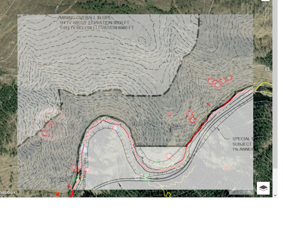 Here is an image overlaying the quarry limits (Sheet 2 Mine Plan) on top of the mountain project climbing area map in the vicinity of the Creekside oxbow. The red line is the creek and was used to match the image scaling. The "dash dash dot" is the limit of mining excavation. The light gray on the top left is the proposed quarry expansion. The dark gray is the undisturbed/buffer area, but still private property. The two existing areas closest to the mining excavation on the left are Conspiracy Crag and Healing Center, as pinned on mountain project. Edit to add: I don't know what access will be like on the undisturbed conservation easement if the quarry expansion is approved, but I know that the BCC has been and will continue to use their experience, skills, and network to work towards the best possible outcome for climbers. If you can, I would recommend that climbers make a monetary donation, technical contribution, or local knowledge to the BCC on this issue. |


