
 Continue with onX Maps
 Sign in with Facebook


Millbrook approach trail
|
|
Hi all, quick question about the approach trail for millbrook and the near trapps. how clear is this trail? like is it pretty well blazed or is it glorified bushwhacking? I'll be up there this weekend and I'm trying to find a less crowded place to hike (the mrs. doesn't climb). I was thinking of taking it to gertrude's nose and back but I've only ever taken the approach trail to around gelsa area. if this is more on the bushwhacking end of this does anyone have any recommendations for less crowded hiking with good views in the gunks area? thanks |
|
|
It's 100% on the carriage road and marked trails. Consult the Preserve's hiking map and you should be all set. If you're bushwhacking, you've done something wrong. |

|
Mike, I think you're talking about the Trapps Road/Coxing Trail approach to Millbrook. This is the most direct way to Millbrook, but it does not go close to the Near Trapps, or follow the ridge at all. It terminates at the Millbrook Mountain Trail, which you can take to the cliff's edge and to the Gertrude's Nose Trail. This route is well maintained and marked. Kurt, I think you're asking about the Millbrook Ridge Trail, does go over the Near Trapps, and which leads into the Gertrude's Nose Trail, following the ridge. I haven't taken the Millbrook Ridge Trail all the way out, but I think it too is maintained and well marked. |

|
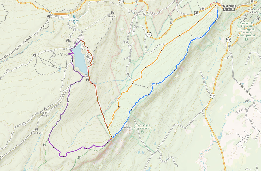
There are four standard ways to get to Millbrook, as shown on the attached map. All of these are marked maintained trails and/or carriage roads. The colors mentioned below are the map colors of the named trails but are not the colors of the blazes. Nos. 1 and 2 start from the West Trapps Lot. Nos. 3 and 4 start from the upper Lake Minnewaska parking lot---there is a per-car entrance fee. No. 4 is a carriage road all the way and so can be biked. Distances are as reported by Gaia GPS.
 |
|
|
Went out to Millbrook last week on the Millbrook Ridge trail - well marked, maintained, clear. |
|
|
OP - if it's not been made clear, you do NOT take the climbers' trail under the Nears to get to Millbrook. Of the routes detailed by rg, I'd say the Millbrook Rdige Trail is your best HIKING option. The other routes may be more attractive to climbers looking to get out there the easiest way i.e. on the carriage roads as much as possible. |
|
|
What happened to driving out there like we did in the 80’s? We Also used bikes from minnewaska |
|
|
Gunkiemikewrote: Yes - it's a nice hike. |
|
|
thanks all for the input. We didn't make it to Millbrook due to rain and thick fog but I'll definitely be using the Millbrook Ridge Trail next time I'm up there now that I know it's maintained all the way through! |


