
 Continue with onX Maps
 Sign in with Facebook


Thunder Ridge COVID-19 Closure - April 2020


|
Pikes Peak Climber Alliance just posted on FB that access to Thunder Ridge has been closed due to the COVID-19 pandemic. Please see the notice below, and PLEASE respect this closure so that permanent access is not threatened. Follow the PPCA Board for updates as the COVID-19 situation progresses. Hey climbers! This was just brought to our attention. The access to thunder ridge has been closed due to the current concerns over the Covid 19 pandemic. Please do not try and access the area. This access is on private property. Respect the wishes of the property owners so that we can reopen access after the epidemic and social distancing time lines are complete. Trying to access this area during could potentially close access permanently. 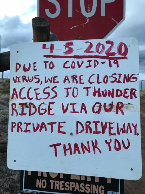 |
|
|
Bump for visibility |
|
|
bump for current info if it's available. seen't a few ticks around the area but i guess that doesn't necessarily mean it is open |
|
|
Still not open. I guess you can access the historical long way, or walk just on the other side of the property line (gaia has a good layer for this) but it would be quite the slog through NFS land. Probs best to write the crag off for this spring unfortunately :( landowners are super cool there, at least maybe we can preserve the positive relationship between them/the climbing community if we all behave. Missing thunder these perfect spring days myself. |
|
|
cool, thanks for the info. will wait for the landowners to green light us |
|
|
Alex Styp wrote: Still not open. I guess you can access the historical long way, or walk just on the other side of the property line (gaia has a good layer for this) but it would be quite the slog through NFS land. Probs best to write the crag off for this spring unfortunately :( landowners are super cool there, at least maybe we can preserve the positive relationship between them/the climbing community if we all behave. Missing thunder these perfect spring days myself. I'm not sure how positive the relationship is. They have been threatening to close access relatively recently due to what seems to be relatively minor traffic, and minor annoyances.(https://www.mountainproject.com/forum/topic/117928360/thunder-ridge-approach-access-threatened). I mean in that linked thread they want to police people on how they drive down the forest service road - they have no right to police anything other than their private property. Thunder is precious and I agree we need to try to work with the landowners, but asking that people not walk on their road due to COVID is f%^&ing ridiculous. I have never had any problems there, and done my best to follow all protocol and show utmost respect. I suggest all climbers do not use the road, even when the landowners lift their ban, and begin to make a path on the forest service land adjacent to the road. |
|
|
John Ryan wrote: Eh it's their land, so imo "thanks for letting us use it this long!". Re: trail, great idea! I for one would be a big fan of putting in a trail next to the road, outside their property, to eliminate any of these conflicts. Super into that and would love to be a part of that project come Summer's end or the fall. |
|
|
still closed? |
|
|
Well? Is TR still closed? |
|
|
Tried last weekend and the covid closure sign was still up. We had some odd run-ins with the hunters to top it off. Apparently you need a fishing or hunting license to be on the land that brings you to Thunder Ridge, and maybe Turkey Rocks as well, now |
|
|
Someone left a USFS flyer on the vehicles in the Thunder Ridge parking lot that day about the hunting and fishing license requirements. Didn't really look in to it much and decided it was best not to be around there for the time being |
|
|
Chalk User wrote: I'm pretty sure the area north of the private property is State Trust land. |
|
|
So get a CPW permit and hike west of the road and everything should be kosher right? |
|
|
I've spent some time on the phone and learned this: 1. As of July 2020, Colorado Parks and Wildlife requires visitors to State Wildlife Areas to have fishing/hunting license regardless of their intentions to hunt or fish. This matters because of the small 4 Mile Creek SWA area you have to cross to get to the TR parking lot. According to the person I talked to, everyone in the car needs a license, or if the car is parked they will look up the license plate to see if the driver has one. So, in theory you could have the driver with the license, roll the dice driving half a mile of the road, and probably get a way with it. |
|
|
I've had a couple of confrontations with him now, and 2/2 he's been piss drunk. Both times we we're polite and respectful and he was an absolute prick. This COVID thing is any excuse he can find to keep people off PUBLIC LANDS. |
|
|
So, I never actually looked at the map until now...outside the SWA issue, which really isn't an impediment to access (but the land owner will definitely use the new regs to try to police the area)....it looks he doesn't actually own the land on the road we're walking on to get to Thunder. |
|
|
I'm sure that people that negotiated the access have already done the hair splitting over the private land boundary location. I do agree that the maps are not super clear. Depending on the map you look at (FS, state,..), the boundary seems to be either at the road, or some distance from it to the west. In the past, I haven't had any issues with the owners. They'd drive by in their truck, everyone waves, and that's it. I understand that they have the right to (dis)allow whatever on their property, but the covid sign does seem like it is about something else. This is why I'd rather hike few extra miles the old way, than try to figure out how to levitate over 3 different jurisdictions. |
|
|
> This is why I'd rather hike few extra miles the old way, than try to figure out how to levitate over 3 different jurisdictions. I'm honestly of the opinion that we tell this drunken clown to pound sand, and let him re-negotiate with the AF (do they even do that anymore, or do they just lobby Washington now?). He's so drunk he can't shoot straight anyway. |
|
|
Sean Bradywrote: There are multiple (3?) households that share that driveway, so this is not just about respecting one guy. FWIW, I've always had good interactions with the landowners I've come across there. |
|
|
Hold up...how is this road private yet all these households "share" it. That's not actually possible unless it's owned by an organization such as an HOA. There's absolutely no way that these other two plots that are out there are cut off from a public access easement, as that (I believe) is illegal in Colorado (zoning). So either they share ownership of it somehow, or it is indeed a forest service road on public lands. |
|
|
Just like G Sule stated earlier, the land ownership is complicated: the parking area is State Land Trust leased to CPW for the 4-mile State Wildlife Area and the land west of the road is USFS. The road crosses between USFS and private property a few times. For a better land ownership map, take a look at the Douglas County GIS map. douglas.co.us/government/de… The parcel to the west of the private property is USFS, but it has other cabin owners listed on that 21,000 acre parcel. Also, the USFS boundary used to be physically marked with little, faded white signs. From memory, most of the boundary signs were right at the road, but the gradual switchback to the west was definitely marked as being on USFS. I assume the private property owners have an easement through the USFS land and the group of local landowners maintain the road. It seems like it might be worth asking the USFS exactly who owns the road, who services it (USFS, utility provider, or home owners), what the easement allows, and/or if a simple access trail could be built (cut a bunch of downed logs) to give this drunk land owner and his guns some social distancing.
|


