
 Continue with onX Maps
 Sign in with Facebook


Ragged mountain ct property dispute
|
|
I saw recently RMF posted about a property dispute with a homeowner claiming people approaching the crag are one their property. Anyone know which approach this is and which house is the issue? |

|
The approach in question is from Andrews st (the social/unoffical trail that goes over a few streams at the start). RMF hired a survey crew to try to settle the issue. From the same typical neighborhood parking you can still approach via Carey st blue trail to small cliff then over to ragged and hopefully not tick off the local guy (regardless of who is right or wrong). |
|
|
Travis is correct. The trail in question is the closest one along Andrews St. There is another trail if you walk down Carey St and head left up the Metacomet trail (blue) towards Small Cliff. Please use caution and avoid confrontation is using the Andrews St entrance. The RMF should be receiving the results of the survey this week. They will notify the public of the results and any policy/procedure changes based on the results of the survey. |
|
|
Topo Gigiowrote: There is no public (or owned by RMF) parking on Andrews. The area you speak of was a former Town of Southington parking area that was subsequently closed down in the 80s. I'm not talking about a specific parking area, but rather a stretch along Andrew's of maybe a quarter mile to half mile or so where there aren't any houses. |
|
|
I decided to look it up on Southington's property listing for my own curiosity. The area I'm referring to is the upper stretch along the road I think. Normally I do the Sheldon parking and approach along Carey to small cliff. 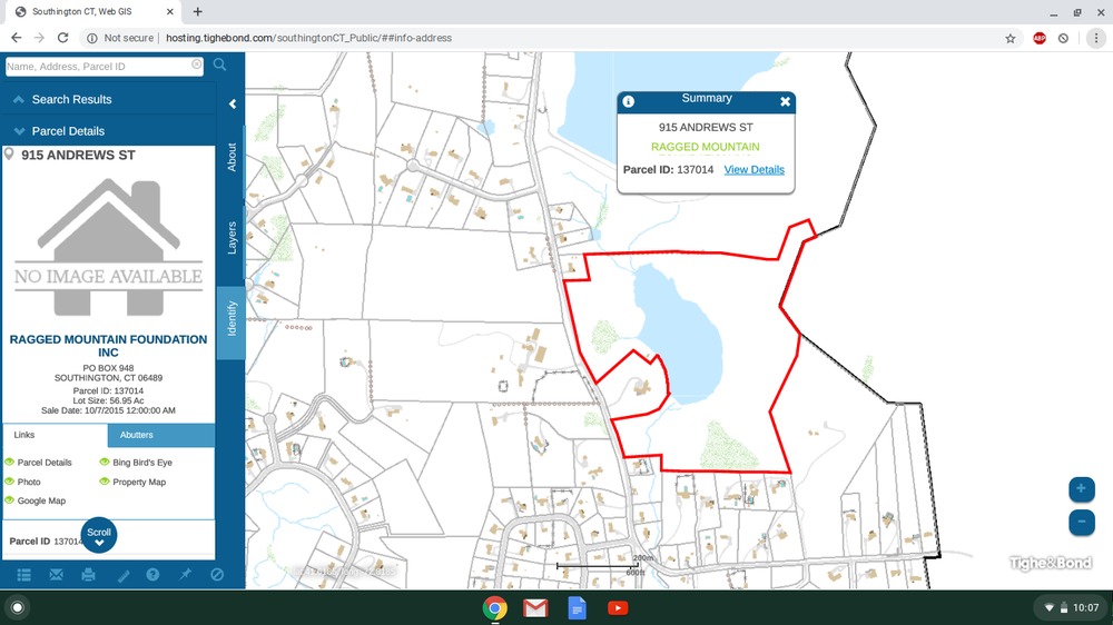 This may sound simplistic or foolish, but couldn't the homeowner in the property dispute just mark where the trail crosses their property and create a new stretch of trail that goes around that? I know RMF isn't allowed to build any new trails because of the conservation agreement or whatever, but I figure the issue could be resolved more amicably with the homeowner if they maybe recruited some climbers interested in keeping access available to help them just take care of it on their own. If I understand correctly, if it becomes a legal dispute RMF could be put into a position of being legally required to move the trail while also legally not allowed to. If a bunch of individuals not connected to RMF took it on themselves to move the trail, wouldn't that solve the problem? |
|
|
Chris - a private entity cannot adversely possess private (or publicly-owned) property. The Town (or State) always owns a proportional amount of footage wider than the physical roadway. People also cannot just park willy-nilly wherever they want either. In fact, this has become an issue at Chatfield Hollow since people started parking on the north side of 80 (across and uphill from the climber's lot). The Town of Southington currently has ordinances in place to prevent parking along certain roads - one of those being Andrews Street (with one exception - discussed in a moment). The stretch of road (i think) you are referring to is also near Karabin Farms. Even with the ordinances in place, people have tried parking there for years. The property owners of Karabin have disliked the use of parking near there for anything BUT parking for their farm. In year's past, the owners of Karabin would call the police to ticket/tow on any hikers/climbers/etc that parked along that stretch of road. On busy weekends for their farm, they get support from Southington PD to allow for parking along the road by them. I highly doubt this is plausible for the RMF to afford, nor even do. |
|
|
Topo Gigiowrote: Chris - a private entity cannot adversely possess private (or publicly-owned) property. The Town (or State) always owns a proportional amount of footage wider than the physical roadway. People also cannot just park willy-nilly wherever they want either. In fact, this has become an issue at Chatfield Hollow since people started parking on the north side of 80 (across and uphill from the climber's lot). The Town of Southington currently has ordinances in place to prevent parking along certain roads - one of those being Andrews Street (with one exception - discussed in a moment). The stretch of road (i think) you are referring to is also near Karabin Farms. Even with the ordinances in place, people have tried parking there for years. The property owners of Karabin have disliked the use of parking near there for anything BUT parking for their farm. In year's past, the owners of Karabin would call the police to ticket/tow on any hikers/climbers/etc that parked along that stretch of road. On busy weekends for their farm, they get support from Southington PD to allow for parking along the road by them. I highly doubt this is plausible for the RMF to afford, nor even do. Thanks for the info. I'm curious, and I really don't know much about the whole situation and the legality involved. I certainly don't mean for my ideas to pose an issue, they're more like me wondering why those things aren't in place than suggestions for what should be done. I'm kinda just getting interested in the conservation and stewardship aspect of hiking, climbing, camping, etc. I was hoping to join RMF on their volunteer trail work days this summer and start to learn more, but covid seems to have put those on hold as far as I can tell from the RMF website. |

|
Is anyone aware of a status update on this? |
|
|
^the "private property no trespassing" sign and the other, more vulgar sign are down. i walked that path and the guy was in his back yard and he didnt say anything to me. there were also a lot of people at ragged that day. this was last week. i'm guessing the survey said RMF owns the property. |
|
|
The entire Andrews St. frontage belonging to the RMF is open to the public for passive recreation. Here's an article from the RMF news letter about the issue. https://www.raggedmtn.org/blog/2020/6/24/good-fences |
|
|
If they were going to take the time to erect a sign that says F*** on it, you’d think they would put in the effort required to abbreviate the word “Mountain” correctly... |
|
|
Nice work guys |
|
|
Just a friendly suggestion as an outsider: |
|
|
David, I think that you ended up parking at the wrong spot for the best approach. I normally park on Sheldon and then walk in using the main approach trail a little ways north on Andrews (on the right hand side of the road). You could get there from Timberlin, but definitely a more confusing route. I definitely agree that we should make a map. There is one at the rear entrance to RMF property, but few climbers use this route in. |
|
|
Ross Ayerwrote: David, I think that you ended up parking at the wrong spot for the best approach. I normally park on Sheldon and then walk in using the main approach trail a little ways north on Andrews (on the right hand side of the road). You could get there from Timberlin, but definitely a more confusing route. I definitely agree that we should make a map. There is one at the rear entrance to RMF property, but few climbers use this route in. I'm trying to draw a rough map for the Mountain Project page so sorry if I'm about to inundate you with a bunch of questions...
Thanks for your help! |
|
|
David Kwrote: Yes, you can hike in that way. When you come out of Bayberry Lane on Carey St go directly across the street to a driveway (park of the Blue/Red trail). Go up that a bit until you see the Blue/Red trail markers on your right and follow that. This brings you in the "back way." It is a much longer approach. We used to use this way back in the day to approach the Small Cliff when there was a small pull-out for parking on Carey Street. |
|
|
For #2, there is a path that cuts more or less straight north from Timberlin park to the end of Milbrook lane, which connects to Carey street. You park at one of the first right side pullouts when you enter the park past the gold course, look on the left side of the street for a faint trail. |
|
|
Brianwrote: Actually, the back way I was referring to is the rear entrance to the RMF property on Wigwam (GPS of Back Lot). As to David: 1: This is the start of the trailhead. I will attach a very unprofessional sketch. 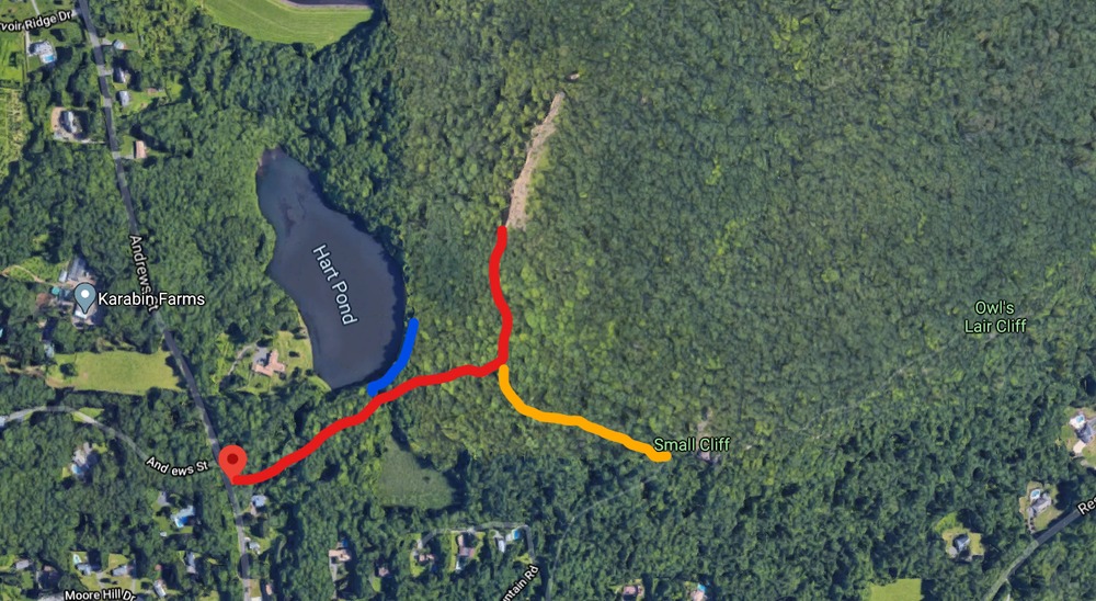 2: I generally don't go if it is overcrowded. The more modern tradition is to park up on the right on Moore Hill Drive. With COVID as well, once the main drag and that is full, it probably is not the best idea to head in anyways. But I personally have not gone from Timberlin, so I do not want to state anything on that topic. 3: Yes. Google has that trail and then take the left turn as Brian has stated. The trail on Google is the light blue blaze that heads up a driveway. The landowner is very nice, so long as we stick to foot traffic only (no bikes, motor vehicles, etc). Let's keep it that way by being respectful! 4: The first link in this is the rear entrance. There is a large parking area here. This is the main hiking lot, but it is a pretty long (hour or so, if memory serves) approach to any cliff from here. |
|
|
Thanks Ross! |
|
|
David Kwrote: Thanks Ross! Glad to help! Okay, I wish you could get to climb Ragged, because it is a great spot. Let me know if you ever make it out here. |
|
|
Ross Ayerwrote: The rock will still be there when there's a vaccine and I'm 33, I should have lots of climbing years ahead of me! I'll send you a message when I make a trip over. |


