
 Continue with onX Maps
 Sign in with Facebook


Maniac 5.13d/5.14a
|
|
The goal is to one day climb this elusive route hidden in Quoddy Head park, but for now I will settle with visiting it just to get a peek and see what I'm dealing with. After much research I am unable to find any information on the internet or mountain project on how to get to the climb. If anyone has any information at all on how to get to the top or bottom of this climb that would be greatly appreciated! |
|
|
https://m.epictv.com/video/climbing/maniac-513d/8b |
|
|
I've watched the video a couple of times and I keep listening, all they really say is that it's on a hiking trail, is there only one trail? I thought there were multiple? |

|
CJ Rumsey wrote: I've watched the video a couple of times and I keep listening, all they really say is that it's on a hiking trail, is there only one trail? I thought there were multiple? It looks like it should be fairly simple to find when you're there. The trails at Quoddy Head are very short and the sections overlooking the ocean are even shorter. Maniac is in a very distinct feature, which I believe is Gulliver's Hole, although it may be the next feature over. The video shows a bench at the top of it. I think when you're at Quoddy Head you'll be able to locate it in quick order. Inspiring looking route for sure! 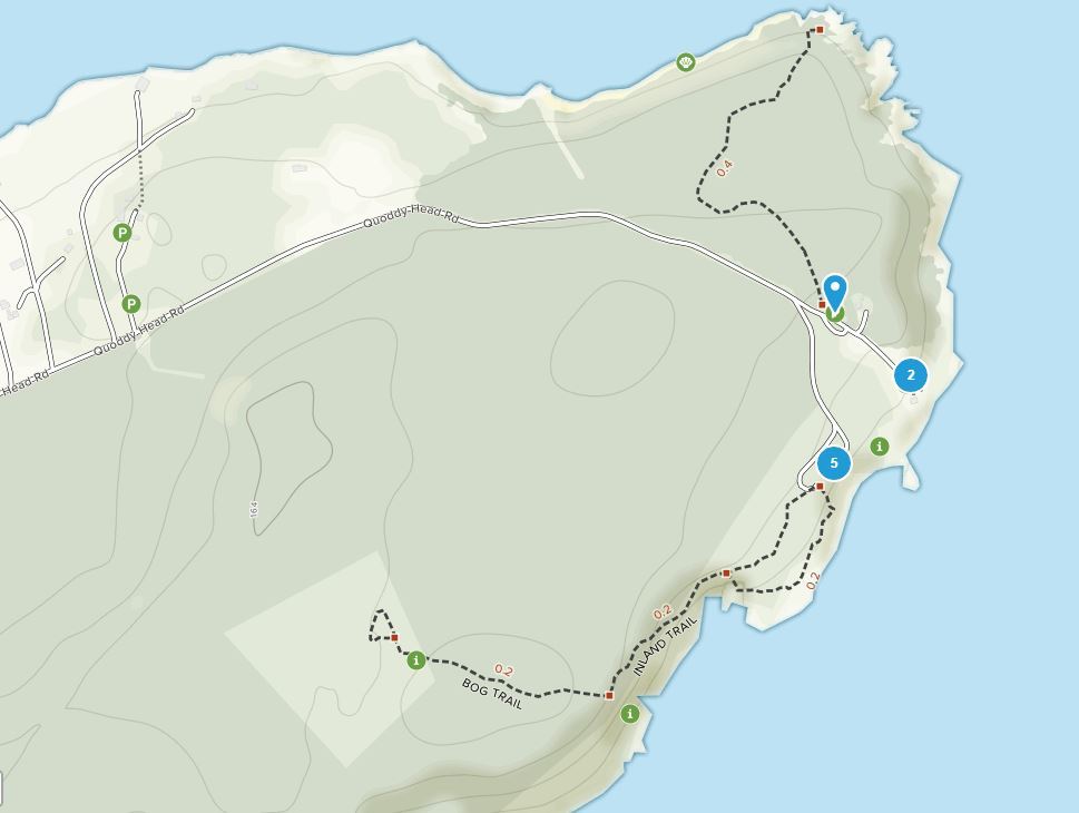 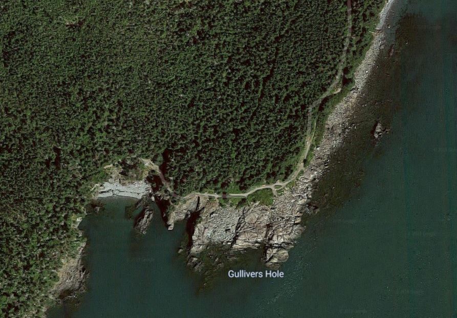 |
|
|
I think it’s at 44.810801, -66.955918 judging by the overview in the videos and comparing to google satellite images. The slab on the right runs down to the cliff and the rock fractures are oriented the same. |
|
|
I'm pretty sure the location of Maniac is actually 44.810885, -66.956121 |
|
|
I went out there to check it out with my college girlfriend, we are talking a long time ago. No info, no internet and it was plainly obvious, a line of rusty bolts. Dan rated it 14a and posted it in the French magazine Vertical, which was strange as he did not tell the american magazines about it, it would have been the first 14a in the US. I thought Alex Honnold and Tim Kemple replaced the bolts and said 13c/d but who knows. Anyway, if you are a rock climber and not brain dead you should be able to find it as I did in the 1980s. Ward |

|
CJ i found the location if you want to give it a shot in the spring. Also could stop by cutler coast... |
|
|
HI I live 30 minutes away by car in Pembroke, Maine. Its a casual 8-9 minute walk from the parking lot to top of the route. A bit longer if you stop to see the incredible views of sea cliffs and ocean. Here are the coordinates for Mainiac from Google Earth: (44.810885°-66.956154°). My Garmin watch says it is "point .32" miles from the parking lot. ( The long gravel "loop" parking lot, not the parking above the awesome West Quoddy Lighthouse.) I start at the trailhead nearest the 2 park restrooms. The sign at the head of the trail says "Inland Trail, Bog Trail 1/4 mile." Take a right when you come out of the woods and see the ocean. ( about a 3 minute walk ) Don't stray from the water/cliff/beach views when on the trail. Stay left at the fork. There is a sign that states, "Peat Bog and Green Point." pointing right. Do not take it. If for some reason you have hiked more than 12 or more minutes turn around, you might have taken it. Arriving at the top of Mainiac there will be a park bench and a fence made of 4 foot high galvanized posts with 3 separate rows of old stainless wire and bad fixtures, somewhat guarding people from the edge. The center pipe is set very solidly but bent. I guess it's my opinion that it's set solidly. Make that decision for yourself! Mainiac is straight out from this bent center post, which is perfectly in line with Mainiac. The walk to the base of Mainiac starts before you get to the top of the route overlook itself. ( the little bit of bushwhacking starts 10 feet before steps, which consists first of a set of utility poles chunked into 4 foot lengths with dirt built up to form stairs. It then changes to vertically set planks with horizontal wooden rungs.) The scramble to the base begins walking up to and around a thigh high boulder. The boulder is about 10 feet before the chunky utility pole steps. The trail to Mainiac and the small boulder is also just after a waist high chain link fence on the initial walk in. Step off of the gravel path by the small boulder, Ocean side, just past the chain link fence and just before the log steps. Go past the small boulder into eroded roots, maybe a bit of mud, and a polished sloping ledge with gravel on it. Veer right along the polished sea cliff. Work your way gently along the buttress / arete to the left, staying level more or less. In 15 or 20 seconds you come around the corner and you are in the amphitheater of Gulliver's Hole. Here lies Dan Goodwin's Mainiac, and the ghosts of Stiletto, Triangulation, and Yellow Dagger. I hope to find the old bolts remnants from these other lines and add titanium Eterna bolts in the near future to these routes Dan put up and bring them back to what they were. The walk to the base of the climb from the top of Mainiac is back down the trail to your left when facing the ocean. A few more notes. There is a sign on the hiking trail that says "Gulliver's Hole" but it's past the bench and fence for Mainiac, and well past the walk to the base. The Gulliver's Hole sign also has a bench but it's not the correct one, ( no bent up galvanized handrail with loose wires in front of it!) although if you are there and if you carefully slink over to the edge you can look over and see the entire route, and see also what you will have to scramble to get to the base of the climb. Here are the rough coordinates for the scramble to the base of the climb (44.811120°-66.955757°) Its the best I could estimate, Google Earth was a bit blurry. I toprope from the base of the center bent handrail pipe with 30 feet of protected (2 inch tubular covered about 9 feet from the toprope carabiners up. ) static line and a ground sheet to protect the static line on the edge, and then obviously a couple lockers for my toprope. I have never had any frays or wear on the tubular covering or the static line so far. I point the static line straight off the pipe directly towards the ocean. The top 6 feet of the climb is an overhanging shelf, and the pipe is set back 6 feet as well. You want your toprope carabiners to hang below the roof so the rope and carabiners don't rub and grind on the edge, this is why I bring 30 feet of static line, plus my toprope rope. After harnessing up and connecting to the pipe with a a 240 cm runner I find the center of my static line and make a fig 8 for my toprope carabiners and put them in. I find center of my toprope at home before the climb and make 2 coils ready to throw. It's just easier than doing it on a dirty small hiking trail. I then clip the toprope center into the lockers, throw both the left and right ropes FAR left. ( away from the Ocean hole ) I then lower the toprope assembly down over the edge. A person at the base of the climb lets me know when the carabiners are hanging free of the shelf/roof. I then trace my static line to the very base of the center pipe, which I have pre- girth hitched with a 2 foot runner and locking carabiners. I tie a figure figure 8 overhand into the static line and connect it to the lockers that are waiting on the runner girth hitched to the base of the pipe. I then then run my static line tails ( that come out out of the figure 8 ) left and right to the other galvanized poles and tie them off, one in each direction. I never have any ropes going over the foot path, or to trees or bushes, or to the park bench. Everything is set up on the climbers side of the fence. The tarp is under all the ledge to protect against rope abrasion. The method I just explained in the previous paragraph is just how I do it, It does not mean you should in any way regard anything I write as proper or safe. Set your system up in a manner that gives you the best safety and security for your experience. Toproping off of the pipes has you relying on anchors that you can not see from below, and the general public is walking past all day long, so consider my methods as only something someone does, not something you should do. Aside from the caution I just wrote it is remarkable how many people are familiar with climbing now and show interest on their walk by. People really for the most part, know a lot about rock climbing and show a lot of knowledge when walking by. The bottom half of the climb is trad and the upper half is sport. The route overhangs about 3ish feet in 70, so if - when you pop off you may swing over the hole above the ocean, Its a fun and exhilarating ride. Have a person with a autolocking belay device like a Birdie, or a Grigri lower you slowly as you pendulum out, and when you come back over rock again have them let you down a little more speedy and fully down onto the rock when you are hovering just above it. Get enough slack from them so you can grip the polished sea rock with your shoes well, it will prevent a repeated pendulum out over the Hole again. Bring Helmets and wear them. The cliff has some rock you can sometimes pendulum into on the swing back in. Also Its pretty hard to get back on route after popping off. The belayer may want to place a small to medium cam in the ledge by their feet so they don't also get yanked out over the ocean water/rock/ledge with the climber. I have a few times. I like the crack about 12 feet from the cliff just before it gets too steep to stand on near the ocean edge, but there are cracks at the base of the climb that go from 1 inch to 2.5. I don't think the high tide reaches the belayer, at least I have not seen it. Maybe I just picked the right time? |
|
|
When passing through the area en route to New Brunswick a few years ago, I had a brief window to try to locate the route, but no information other than that it was on Quoddy Head. I can attest that, under those circumstances, it was definitely not easy to locate--and I failed to do so. So, Ward, I guess that I am either not a rock climber or am brain dead--thanks for letting me know. |
|
|
Alan Rubinwrote: I don't think its an either/or. If you try hard both can be true. |
|
|
Are there other routes there for the less than legendary climbers? Wife and I visited a while back but we are not even 5.12 climbers. Maybe some fa potential? |
|
|
Alan Rubinwrote: I love how the most sarcastic response was from a serial guidebook author. |
|
|
I stumbled upon this climb while on a day hike a few years ago. there are 2 newish glue in bolts at the top just beyond the fence at one of the memorial benches. Ten minutes or so from parking area. I was able to easily scramble down to the base of the climb for a good look. The climb is in the back of a deep cleft that cuts in to the rocky shoreline. If you hike past the bench and out on to the cliff top rocks you get great view looking into the cleft at the climb. Very steep, smooth, and impressive line. It was very freshly chalked up when I first saw it. I had to do some googling to figure out what I was looking at. |


