
 Continue with onX Maps
 Sign in with Facebook


Wind River Range 2018 Conditions


|
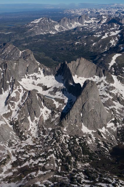 Great aerial photograph of Wolf's Head/ Pingora in the foreground, the East Fork Valley in the background. Photo was taken three days ago. |

|
Wow...great shot! |
|
|
As of the fourth of July, there was still a long steep snow field in the Wolf's Head descent basin as well as the approach to Warrior 1. |
|
|
A-K wrote: |
|
|
https://www.greatoutdoorshop.com/blog/2018/07/08/trailhead-conditions-report-7-8-2018/
Not much new to say. Snow line is sitting around 10,800-11,000 ft. Skied perfect spring snow on Thursday, so it's still pretty socked in up high, but it's going fast. Passed a LOT of parties doing Gannett. Sounds like the 'shrund is open but the snow bridge is thick and intact. Snow is nice and set up; no more postholing. Bugs are BAD. Bring yer Deet. |
|
|
Looking to do the East Ridge on Wolf’s Head sometime in the next week or so. Anyone done it yet this season? Trying to avoid snow travel. Any beta is much appreciated! |
|
|
Will Maness wrote: Looking to do the East Ridge on Wolf’s Head sometime in the next week or so. Anyone done it yet this season? Trying to avoid snow travel. Any beta is much appreciated! Look at the photo up higher. Def still snow on approach and descent. |
|
|
On the topic of poop: |
|
|
My partner and I are considering climbing Musembeah in mid-August. Do the winds get any relief from the bugs later in the summer, or should we anticipate them being as bad as stated previously in this thread? Any opinions on which route into Baptiste is more enjoyable (less worse)? |
|
|
Kevin Pula wrote: My partner and I are considering climbing Musembeah in mid-August. Do the winds get any relief from the bugs later in the summer, or should we anticipate them being as bad as stated previously in this thread? Any opinions on which route into Baptiste is more enjoyable (less worse)? I've been early September and the bugs were insignificant. We did wake up to snow one morning, though. |
|
|
Kevin Pula wrote: My partner and I are considering climbing Musembeah in mid-August. Do the winds get any relief from the bugs later in the summer, or should we anticipate them being as bad as stated previously in this thread? Any opinions on which route into Baptiste is more enjoyable (less worse)? Go from Big Sandy over Hailey Pass and the bugs are better by then. If there has been a frost they'll be a lot better. But..... Musumbeah is on the Wind River Indian Reservation and so you are required to buy a "fishing" permit to recreate on their lands. The boundary goes through Baptiste Lake. |
|
|
Just received word that the snow bridge across the Gooseneck Gully bergshrund will probably not last through the weekend. |
|
|
DavisMeschke Guillotine wrote: Just received word that the snow bridge across the Gooseneck Gully bergshrund will probably not last through the weekend.I agree- did the Gooseneck route on 7/11 and the bridge over the schrund was maybe 4 or 5 feet wide. There was a lot of rain over the course of our trip so I can’t imagine it will last much longer. |
|
|
DavisMeschke Guillotine wrote: Just received word that the snow bridge across the Gooseneck Gully bergshrund will probably not last through the weekend. As in today/tomorrow?! So if I'm planning to go for the summit solo on Tuesday, I'm SOL? |
|
|
Steve H wrote: Not SOL. You can climb the rock to the right of the snow bridge and it goes at 5.2-5.3. I'm going off what people have told me, since I haven't been up there yet this year. My experience has been that the snow bridge lasts usually until late July/early August, but in leaner snow years it melts faster. |
|
|
Will Maness wrote: Looking to do the East Ridge on Wolf’s Head sometime in the next week or so. Anyone done it yet this season? Trying to avoid snow travel. Any beta is much appreciated! The snow on the Tiger Tower approach wasn't bad. On the descent there is a rappel to get you past the steepest bit of snow. No ice axe or crampons necessary. |
|
|
https://www.greatoutdoorshop.com/blog/2018/07/17/trailhead-conditions-report-7-15-2018/
Not much new to report, other than what I've updated with periodiclly here over the past few weeks. It's alpine season! The bugs are bad though... |
|
|
Baaadddd bugs in the East Fork Valley. Much better in The Cirque, for us. |
|
|
thx for all the updates. |
|
|
splitclimber wrote: thx for all the updates. I have not done that particular route, but we did get on Shark's Nose Southwest Face last week... After you are out of the col, the walk is all talus. Took us about an hour to get to the col, from Shadow Lake, and then took less than that to get down. We bailed off Shark's Nose (got off route) and then took the same col out. It is very straight forward. You can see the approach and descent from the lake. |


