
 Continue with onX Maps
 Sign in with Facebook


Anyone climbed at this spot near Drake CO?
|
|
So I found this whilst scanning Google maps a while back: |
|
|
 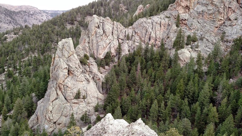 A couple shots of the East side of the canyon. The west side was taller but we didn't go down to take shots of it. |
|
|
Wow, looks super nice. Get a double rack, a hand drill, and hit that. Make your own topo for your buds. |
|
|
That was definitely a consideration, Stitch. And whilst we were looking at satellite images we nicknamed the area Magrathea. But ultimately we decided that we currently don't have the experience or knowledge we feel we need to establish it in any meaningful way at this point.  |
|
|
More than likely it has some trad lines, but information about them is locked away in the minds of Olde and Newe that do not Say Much online. Hopefully someone will contact you, just so you can get some info. But seriously, go check it out yourself. I have areas near me to explore, but that could be your own playground for now. The bolt kit is if you go for the whole ground up gusto and run into blank rock, or just or rap off if you get stuck. You can of course leave a two nut rap anchor or sling some horns/flakes as well, your choice. |
|
|
This is the rock band across the valley from Combat Rock correct? I have seen it before and haven't heard anything from anyone about it. It looks climbable and fun terrain. Might have to check it out one of these days! |


|
Mathias, I will go up there with you this weekend if you want. Also shoot Ken Duncan ( mountainproject.com/u/ken-d…) a PM. He has put up a ton of stuff recently in the Big Thompson, e.g. Crosier. I bet he would know. |
|
|
Bill, part of my issue is very limited time. I just got married and we're having a hard time getting out to climb at all, so this just seems like a bit much. But if you or anyone else is interested in climbing out there, I can give more detailed directions based on the Crosier Mountain Trail. |
|
|
Looks like the "Palisades" to me. You can see them from 34 on your way up to Estes. The spire in your first photo is called the Cardinal, because it looks like the crest of a bird from the road. It's 2.5 pitches from the base. |
|
|
John Byrnes wrote:Looks like the "Palisades" to me. You can see them from 34 on your way up to Estes. The spire in your first photo is called the Cardinal, because it looks like the crest of a bird from the road. It's 2.5 pitches from the base. The Palisades were "developed" in the 80's. I know Jim Brink and Craig Luebben were quite active, among others. I put up two routes with Craig on the Cardinal but I remember him saying most of the cherry crack lines had been already done. It was a conscious decision to keep the area undocumented to preserve the sense of adventure. It's nice to know that that decision is still in force. I'd say Brink is your best bet for info. The best approach is a blurr in my mind, but we did it from the top (driving past Combat into whatever that park is called up there) and it was a maze... Hey there John, |
|
|
Okay, you're right. So are these are the rocks you see across the river when climbing at Combat? If so, then I hiked up there one day intending to climb but the rock quality was pretty bad, so we didn't. Of course, that was decades ago when my idea of "quality" was quite different than it is today ;-) |
|
|
John Byrnes wrote:Okay, you're right. So are these are the rocks you see across the river when climbing at Combat? If so, then I hiked up there one day intending to climb but the rock quality was pretty bad, so we didn't. Of course, that was decades ago when my idea of "quality" was quite different than it is today ;-) John, I've only climbed at Combat once and so I'm really not sure. If you've looked at the spot on the map with the satellite view, it'll probably tell you more than I can. But it seems likely we're talking about the same place. A deep narrow valley with crags on both sides, located up hill from a small house just on the edge of the road? |
|
|
Mathias wrote: John, I've only climbed at Combat once and so I'm really not sure. If you've looked at the spot on the map with the satellite view, it'll probably tell you more than I can. But it seems likely we're talking about the same place. A deep narrow valley with crags on both sides, located up hill from a small house just on the edge of the road? I just looked at the satellite view again, and I'm quite sure these are the rocks we hiked up to sometime around '90. The buildings to the North are all "matched" in appearance and obviously have a single owner. The main crag has an obvious chimney or OW on the side that faces Combat. |
|
|
Thanks for the info, John. Good story about the wiper blades. Those folks up there don't seem to friendly, whilst looking at the property line I was shouted at by a property owner from across the river. She wasn't very pleasant so we decided to hike around. |


