
 Continue with onX Maps
 Sign in with Facebook






All Locations >
Utah
> Wasatch Range
> Central Wasatch
> Little Cottonwo…
> Boulders - Litt…
> Riverside
Ray’s Boulder Climbing

Use onX Backcountry to explore the terrain in 3D, view recent satellite imagery, and more.
Now available in onX Backcountry Mobile apps! For more information see this post.
| Elevation: | 5,717 ft | 1,743 m |
| GPS: |
40.57166, -111.75709 Google Map · Climbing Area Map |
|
| Page Views: | 1,531 total · 21/month | |
| Shared By: | Burnie Senders on Oct 4, 2020 · Updates | |
| Admins: | Drew B, Perin Blanchard, GRK, David Crane, Nathan Fisher |
 Access Issue: Gate Buttress Area Recreational Lease: Climbs on Church Buttress above vault remain closed
Details
Access Issue: Gate Buttress Area Recreational Lease: Climbs on Church Buttress above vault remain closed
Details
Climbers Partner with LDS Church on Stewardship of Little Cottonwood Canyon Climbing
June 1st, 2017:The Salt Lake Climbers Alliance (SLCA), the Church of Jesus Christ of Latter-day Saints (LDS Church), and Access Fund announce the signing of an unprecedented lease for 140 acres in Little Cottonwood Canyon (LCC). The parcel, known as the Gate Buttress, is about one mile up LCC canyon and has been popular with generations of climbers because of its world-class granite.
The agreement secures legitimate access to approximately 588 routes and 138 boulder problems at the Gate Buttress for rock climbers, who will be active stewards of the property. The recreational lease is the result of several years of negotiations between LDS Church leaders and the local climbing community.
Access Note: The climbs on the Church Buttress above the vault as well as the Glen boulders that have been traditionally closed will remain closed.
Please help us steward this area and leave no trace.
Read More:
saltlakeclimbers.org/climbe…
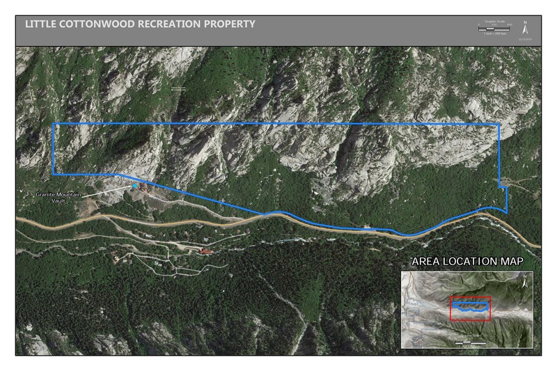
June 1st, 2017:The Salt Lake Climbers Alliance (SLCA), the Church of Jesus Christ of Latter-day Saints (LDS Church), and Access Fund announce the signing of an unprecedented lease for 140 acres in Little Cottonwood Canyon (LCC). The parcel, known as the Gate Buttress, is about one mile up LCC canyon and has been popular with generations of climbers because of its world-class granite.
The agreement secures legitimate access to approximately 588 routes and 138 boulder problems at the Gate Buttress for rock climbers, who will be active stewards of the property. The recreational lease is the result of several years of negotiations between LDS Church leaders and the local climbing community.
Access Note: The climbs on the Church Buttress above the vault as well as the Glen boulders that have been traditionally closed will remain closed.
Please help us steward this area and leave no trace.
Read More:
saltlakeclimbers.org/climbe…
Description

The first very large boulders you’ll face after passing the Syringe/Heroin boulder and hanging a right at the fork. It’s a large triangular boulder with a nice V0 arete on either side. Hard to miss — it’s pretty directly on the path and is no more than 90 seconds or so from the parking. The right arete of the boulder is distinctive for a series of manmade drilled grooves every several inches all the way up, and is the easier of the two aretes.
NOTE: this boulder is liable to be destroyed by the incoming gondola, so get on it while it still exists.
Classic Climbing Routes at Ray’s Boulder
Mountain Project's determination of the classic, most popular, highest rated climbing routes in this area.
 Sun Angles Details:
Weather Averages
|
High
|
Low
|
|
Precip
|
Days w Precip
|
Prime Climbing Season
| J | F | M | A | M | J | J | A | S | O | N | D |
| J | F | M | A | M | J | J | A | S | O | N | D |


All Photos Within Ray’s Boulder
Most Popular · Newest · RandomMore About Ray’s Boulder
Printer-FriendlyWhat's New


0 Comments