
 Continue with onX Maps
 Sign in with Facebook


Hassler Crag Climbing
Routes in Hassler Crag

|
Anorexia Crack T,TR 5.11c 6c+ 24 VIII- 24 E4 6a PG13 |
|
|
Armageddon Destructor S,TR 5.12c 7b+ 27 IX- 27 E6 6b |
|
|
Ashes to Ashes T,TR 5.8 5b 16 VI- 15 HVS 4c |
|
|
Baby Snakes T,TR 5.10a 6a 18 VI+ 18 E1 5a |
|
|
Beginning, The V0 4 |
|
|
Bionic T,TR 5.11c 6c+ 24 VIII- 24 E4 6a R |
|
|
Bones V5 6C |
|
|
Claudes Hairy Crack T,TR 5.8 5b 16 VI- 15 HVS 4c |
|
|
Comfortably Numb T,TR 5.11b 6c 23 VIII- 23 E3 5c |
|
|
Couch Trip T,TR 5.5 4b 13 IV+ 11 MS 4a |
|
|
Cowboys Way, The T,TR 5.11c 6c+ 24 VIII- 24 E4 6a |
|
|
Dangerous Geometry T,TR 5.10a 6a 18 VI+ 18 E1 5a R |
|
|
Dark Warrior T,TR 5.10b 6a+ 19 VII- 19 E2 5b |
|
|
Dashed Dreams T,TR 5.11b 6c 23 VIII- 23 E3 5c PG13 |
|
|
Deflowering, The T,TR 5.9 5c 17 VI 17 HVS 5a |
|
|
Discipline Hand, The T 5.10c 6b 20 VII 20 E2 5b |
|
|
Diversion V1 5 |
|
|
Double Take T,TR 5.8 5b 16 VI- 15 HVS 4c |

|
Dreamer S,TR 5.11a 6c 22 VII+ 22 E3 5c PG13 |
|
|
Dust to Dust T,TR 5.8 5b 16 VI- 15 HVS 4c |
|
|
Ellipsis V3 6A |
|
|
Flesh & Bone T 5.10b 6a+ 19 VII- 19 E2 5b R |
|
|
Giving Birth V2 5+ |
|
|
Grand Central Station T,TR 5.10+ 6b+ 21 VII+ 20 E3 5b R |
|
|
Growth Spurt T,TR 5.9 5c 17 VI 17 HVS 5a |
|
|
Hammock TR 5.10b 6a+ 19 VII- 19 E2 5b |
|
|
High Lift V2 5+ |
|
|
High Pressure Test T 5.10b 6a+ 19 VII- 19 E2 5b |
|
|
Hissy Fit T,TR 5.9 5c 17 VI 17 HVS 5a PG13 |
|
|
In the Shadows T 5.10c 6b 20 VII 20 E2 5b |
|
|
Inclined T,TR 5.7 5a 15 V+ 13 MVS 4b |
|
|
Incredible Layback, The T,TR 5.10a 6a 18 VI+ 18 E1 5a |
|
|
Jay in the Shade T 5.10d 6b+ 21 VII+ 21 E3 5b |
|
|
Jory's Glory T,TR 5.10c 6b 20 VII 20 E2 5b |
|
|
Lean Back V3 6A |
|
|
Lean To V1 5 |
|
|
Leg Twist V3 6A |
|
|
Limber S,TR 5.11c 6c+ 24 VIII- 24 E4 6a |
|
|
Lost Boys, The TR 5.12a 7a+ 25 VIII+ 25 E5 6a |
|
|
Mid-Line Crisis T,TR 5.10c 6b 20 VII 20 E2 5b |
|
|
Mighty Mouse T,TR 5.10c 6b 20 VII 20 E2 5b |
|
|
Motherless Child T,TR 5.6 4c 14 V 12 S 4b |
|
|
Nawt Lews V1 5 |
|
|
Nose Goblins T,TR 5.7+ 5a 15 V+ 13 MVS 4b |
|
|
Numb Is Not Enough TR 5.10b 6a+ 19 VII- 19 E2 5b |
|
|
Ondra, The V4+ 6B+ |

|
Peter Pan S,TR 5.11b 6c 23 VIII- 23 E3 5c |
|
|
Pooket V1 5 |
|
|
Pressure Cooker T,TR 5.6 4c 14 V 12 S 4b |
|
|
Project V5 6C |
|
|
Project S,TR 5.11 6c+ 23 VIII- 23 E4 5c |
|
|
Put in a Holding Pattern T,TR 5.10 6b 20 VII- 19 E2 5b |
|
|
Quick and the Dead, The T,TR 5.10d 6b+ 21 VII+ 21 E3 5b |
|
|
Revelations S,TR 5.10c 6b 20 VII 20 E2 5b |
|
|
Rise and Shine V3 6A |
|
|
Self Service Pump S,TR 5.10b 6a+ 19 VII- 19 E2 5b |
|
|
Shady Side T,TR 5.7+ 5a 15 V+ 13 MVS 4b PG13 |
|
|
Shake & Bake T,TR 5.9 5c 17 VI 17 HVS 5a |
|
|
Shortcut V0 4 |
|
|
Sissy Fit T 5.8 5b 16 VI- 15 HVS 4c |
|
|
Smee S 5.11a 6c 22 VII+ 22 E3 5c |
|
|
Snake Flake T,TR 5.8 5b 16 VI- 15 HVS 4c |
|
|
Squeeze Me V3 6A |
|
|
Stone Golem V1 5 |
|
|
Stumpy TR 5.8 5b 16 VI- 15 HVS 4c |
|
|
Sudden Impact T,TR 5.10c 6b 20 VII 20 E2 5b |
|
|
Sweet Spot V4 6B |
|
|
Texas Tunnel T,TR 5.9 5c 17 VI 17 HVS 5a |
|
|
Thread Fall T,TR 5.10a 6a 18 VI+ 18 E1 5a |
|
|
Timber V5 6C |
|
|
Tipping Point V4 6B |
|
|
Titty Bean S,TR 5.10a 6a 18 VI+ 18 E1 5a |
|
|
Trigger Finger Syndrome S,TR 5.11b 6c 23 VIII- 23 E3 5c |
|
|
Wake up! S,TR 5.12d 7c 28 IX 28 E6 6b |
|
|
Wall Hug T,TR 5.10a 6a 18 VI+ 18 E1 5a |
|
|
Wall Hug Crack T,TR 5.10a 6a 18 VI+ 18 E1 5a |
|
|
Wanglin T,TR 5.10a 6a 18 VI+ 18 E1 5a |
|
|
Warriors Traverse T 5.8 5b 16 VI- 15 HVS 4c |
|
|
Way of the Warrior T 5.10b 6a+ 19 VII- 19 E2 5b |
|
|
Weekend Warrior T,TR 5.7 5a 15 V+ 13 MVS 4b |
|
|
Wendy T,TR 5.9 5c 17 VI 17 HVS 5a PG13 |
|
|
Will to Live, The T 5.9 5c 17 VI 17 HVS 5a |
|
|
Zig Zag TR 5.10c 6b 20 VII 20 E2 5b |
Order Wrong?
Sort Routes
Use onX Backcountry to explore the terrain in 3D, view recent satellite imagery, and more. Now available in onX Backcountry Mobile apps! For more information see this post.
| Elevation: | 2,212 ft | 674 m |
| GPS: |
55.61555, -121.89393 Google Map · Climbing Area Map |
|
| Page Views: | 25,664 total · 428/month | |
| Shared By: | Chris Gordon on Mar 27, 2020 · Updates | |
| Admins: | Mark Roberts, Kate Lynn, Braden Batsford, Mauricio Herrera Cuadra |
Description

Secluded sandstone/ conglomerate rock crag south facing. 20+/-m cliffs, 60+ routes.
Sport, top-rope, bouldering & trad climbing.
Getting There
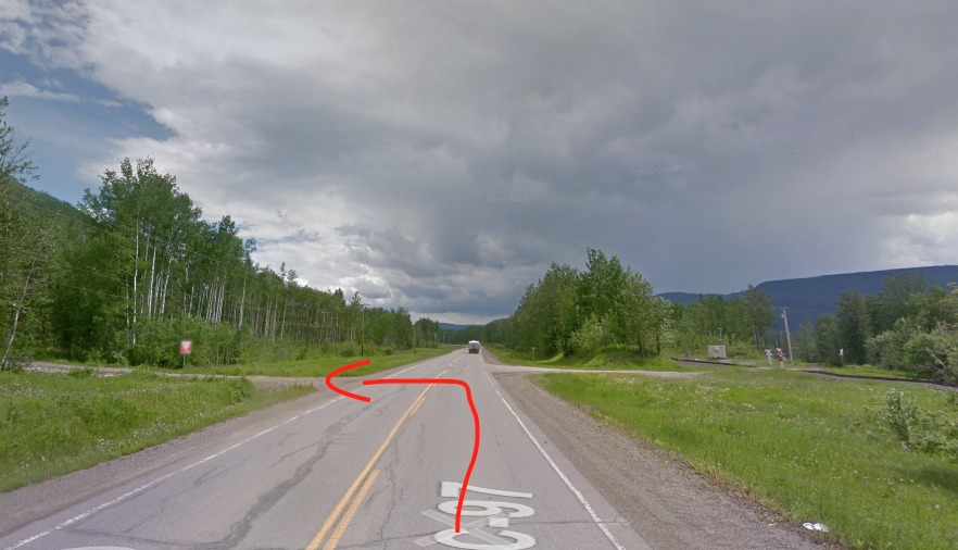
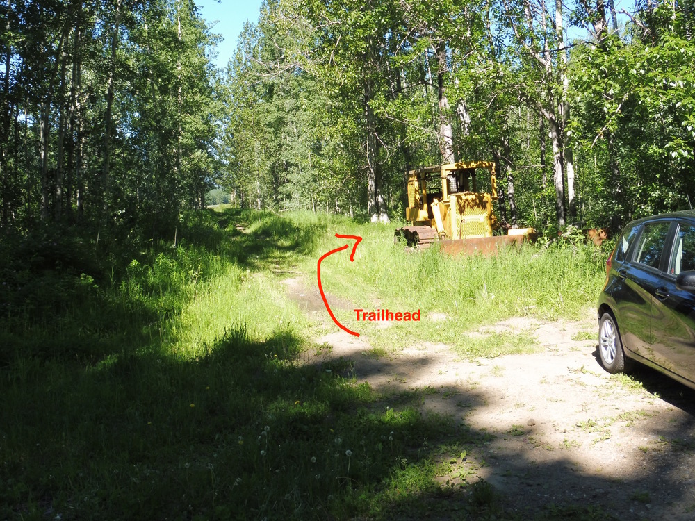
20km West of Chetwynd on Highway 97.
280km North of Prince George on Highway 97.
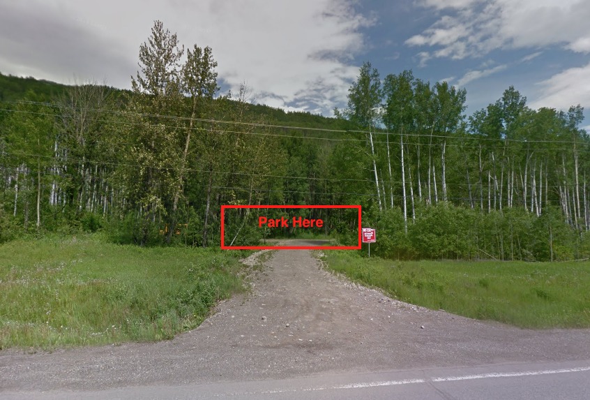
Crag parking opposite of Houde road.
Photos courtesy of: rockclimbpg.ca/climbing-are…
Classic Climbing Routes at Hassler Crag
Mountain Project's determination of the classic, most popular, highest rated climbing routes in this area.
Sun & Shade
Routes Mostly Face: West
Sunny Roughly 9am to 6pm
during high season
6am
8pm
Weather Averages
|
High
|
Low
|
|
Precip
|
Days w Precip
|
Prime Climbing Season
| J | F | M | A | M | J | J | A | S | O | N | D |
| J | F | M | A | M | J | J | A | S | O | N | D |


All Photos Within Hassler Crag
Most Popular · Newest · RandomMore About Hassler Crag
Printer-FriendlyWhat's New
Guidebooks (5)


0 Comments