
 Continue with onX Maps
 Sign in with Facebook


The Nose Rock Climbing
Use onX Backcountry to explore the terrain in 3D, view recent satellite imagery, and more. Now available in onX Backcountry Mobile apps! For more information see this post.
| Elevation: | 4,339 ft | 1,323 m |
| GPS: |
42.72046, -113.06543 Google Map · Climbing Area Map |
|
| Page Views: | 11,782 total · 206/month | |
| Shared By: | Mike Engle on Jan 24, 2020 | |
| Admins: | Mike Engle, Eric Bluemn |
Description

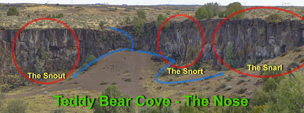
The Nose is the ‘nose’ region of the ‘Teddy Bear’. There is a down climb from the rim at the high point of the dune in the alcove. The area has 3 developed crags: The Snout, The Snort, and The Snarl. This area is a good option for morning shade in the summer (shade until about 1 pm) or afternoon sun in the late fall, winter or early spring.
![]()
Classic Climbing Routes at The Nose
Mountain Project's determination of the classic, most popular, highest rated climbing routes in this area.


Weather Averages
|
High
|
Low
|
|
Precip
|
Days w Precip
|
Prime Climbing Season
| J | F | M | A | M | J | J | A | S | O | N | D |
| J | F | M | A | M | J | J | A | S | O | N | D |


All Photos Within The Nose
Most Popular · Newest · RandomMore About The Nose
Printer-FriendlyWhat's New
Guidebooks (1)


0 Comments