
 Continue with onX Maps
 Sign in with Facebook


Labyrinth Rock Climbing

| Elevation: | 6,033 ft | 1,839 m |
| GPS: |
39.7537, -105.25043 Google Map · Climbing Area Map |
|
| Page Views: | 4,787 total · 31/month | |
| Shared By: | ChefMattThaner on Dec 9, 2013 | |
| Admins: | Shirtless Mike, Leo Paik, John McNamee, Frances Fierst, Monty, Monomaniac, Tyler KC |
 Access Issue: Seasonal Raptor Closures
Details
Access Issue: Seasonal Raptor Closures
Details
Raptor Closures Effective February 1-July 31
Visit: jeffco.us/open-space/news/2…
Tunnel 1 closure
For more details visit: jeffco.us/open-space/alerts…

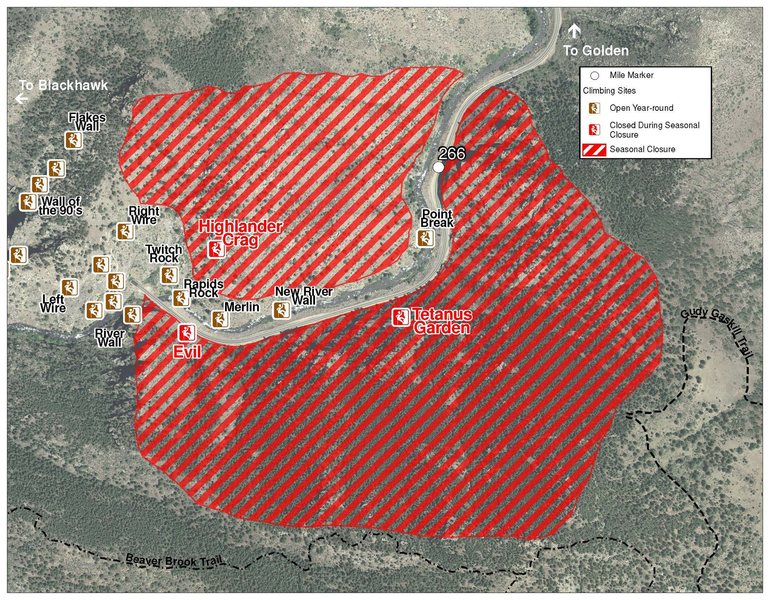
The two areas Jefferson County Open Space intends to close in Clear Creek Canyon, shown on the attached maps, encompass the active eagle nests. If the Clear Creek eagles continue to nest in the active nests, these areas will remain closed from February 1 through July 31. If the eagles choose different nesting sites, the closures will be adjusted accordingly to protect those eagles during their breeding season.
Currently, rock climbing areas that fall inside of the seasonal raptor closures include:
Blonde Formation
Bumbling Stock
Evil Area
Ghost Crag
Highlander
Skinny Legs
Stumbling Block
Tetanus Garden
Fault Caves
Description

This is a small, undeveloped crag right above the west side of tunnel 1. This area is currently only trad and TR as no bolts have gone in yet. This area is very sunny in the summer as it faces due south, so avoid those hot days in the middle of the summer, but it will be good on warm winter days. The rock on the shorter, smaller, left side is still in need of cleaning but nothing too terrible. The larger more exciting face to the right is also sufferring from a much needed exfoliation. Most routes can be done with walkoffs, but some of the descent is a bit loose and requires caution. There are a few top anchor slings with ACRs on them I have left on routes I like to go back to. Use caution when approaching the bottom of the routes as the trails up to the walls are still very loose and harbors potential for rockfall.
Getting There
Take US Hwy 6 from Golden to Clear Creek Canyon. Park at the small, dirt parking area on the right near the "Welcome to Clear Creek Canyon park" wooden sign about 1/4 mile up from the mouth of the canyon. There is also a small pullout spot 0.4 miles past this one on the right hand side.
From the first parking area, take the obvious trail mostly west along the highway until it heads north a bit to bring you directly to the bottom of the labyrinth and the larger crag. From the second small pullout, hike directly north up the hill you are parked right next to, and this will bring you to the bottom of the crag with Dadaelus on it as well. Both approaches are less than 5 minutes, with the second one being slightly longer and tougher since it is all uphill.
Weather Averages
|
High
|
Low
|
|
Precip
|
Days w Precip
|
| J | F | M | A | M | J | J | A | S | O | N | D |
| J | F | M | A | M | J | J | A | S | O | N | D |
Photos


All Photos Within Labyrinth
Most Popular · Newest · RandomMore About Labyrinth
Printer-FriendlyWhat's New


0 Comments