
 Continue with onX Maps
 Sign in with Facebook


Help Identifying Formation in Josh


|
Recently acquired this old real photo postcard of a rock formation in Joshua Tree. I thought I had identified where it was taken, but that turned out to be incorrect. Can anyone help? Thank you.  |
|
|
Very cool photo. Can you read what the text is on the bottom of the photo? Does it give any clues? |
|
|
Trashcan Rock, Qual Springs picnic area |
|
|
Matt Nwrote: Duh! Thank you so much. |
|
|
Here is another fun real photo postcard. Crag looks basically the same about 90 years after this was taken.  |
|
|
Randywrote: The wildest part of this postcard is that nobody is on Double Cross |
|
|
Matt Nwrote: Definitely. You can see Filch running up the middle. |
|
|
Obviously OP doesn't know much about Joshua Tree. |
|
|
D Kwrote: Hahaha |
|
|
Okay, Here is another card that I am having trouble identifying the formation in the background. I had to crop the image so as not to raise the ire of MP moderators -- so it is slightly tilted. I'm inclined to think it is in the Echo Cove area.  |
|
|
Rad postcards! Doing research for Jtree Central??? |
|
|
David Nwrote: Just got interested in these a number of years ago, mostly just as documentation of the crags before technical climbing and for fun. The one above is a card with Lisa Lyons, the body builder, taken by Robert Mapplethorpe. |
|
|
Randywrote: Would love to see the whole Mapplethorpe photo. Had no idea he was ever in Josh. |
|
|
Big Hunk  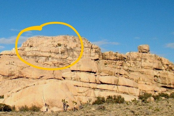 Another view  (Photo by Adam Stackhouse) |
|
|
Excellent Chris. Thank you! |
|
|
No worries, Randy, glad to assist. |
|
|
Can you read what the text is on the bottom of the photo? Desert Queen Country |
|
|
|
|
|
OK, here is another picture that has me stumped (apparently not too difficult to do).  |
|
|
Randywrote: Looks like the Lost Horse Ranger Station Road. |
|
|
I'm not very good at this game (and I love the irony that Randy isn't either) but I do enjoy it. Until the smart guys chime in, I'm gonna say something like Quail Springs Wash. Didn't the road originally go in that way? Not sure when it became the current path, but there is a "historic" trail/road that branches off the wash, I think. |


