
 Continue with onX Maps
 Continue with Facebook


Mount Wilson descent
|
|
Hi!
Topped out for the second time on Sunday, and it took us 8 hours to get back to the car, down some pretty messed up raps. My first experience was pretty much the same, and I figured it would be easier this time (think we went down a different drainage but there were messed up raps last time too). From my understanding, there should be no raps at all on this descent… I feel like we tried to follow the beta on mp as best as we could, and followed some cairns that went down the “rock ridge line” that seem to suddenly stop, and there wasn’t any limestone in sight. We had to choose a way to go and stick with it after that— maybe this was the coveted second drainage? Pretty sure we encountered this exact point of confusion last time as well.
|

|
You could try the hidden bowl descent out of first creek, it's really straight forward. |
|
|
I've done it twice. Nailed it once and and totally screwed it up the other time. My only beta is to do it in daylight! |
|
|
Thanks for the messages! First creek is pretty well documented, we chose oak creek because it seemed to be much more recommended on the mp page for the Aeolian wall. Maybe first creek is the better option, although it’s longer? Was hoping to see if I could improve my own beta for the oak creek descent and just go up there to try it out one day, tracking it on an app to maybe add to the map here? Also, perhaps the best beta is just to do it in the light! We had plenty of time when we did inti to res arete (first time up Wilson) but had to wait for our second party. This time we topped out Woman of mountain dreams just as the sun set, but could have definitely improved our time. Things to learn! |

|
Having sampled all of the decent options, the clever crack route is the fastest, but has the highest consequences if you mess up the route finding. This one is a shortcut of the oak creek decent option, it has one rappel or 5.2(old school 4th) downclimb, and plenty of 3rd and 4th class. https://www.summitpost.org/cleaver-crack/394684 <- follow these instructions backwards. |
|
|
Ok upon further inspection into the depths of the Wilson page, there seems to be documentation available from hikers doing the oak creek (and first creek) trail up to wilson, car to car: https://fastestknowntime.com/route/mt-wilson-red-rock-canyon-nca-nv I'm wondering if these are correct? Maybe we could work on adding them to the mp? or adding some type of beta to the page for easy access of these trails? I could see if I could slice them in half so it only includes the descent part of the gpx? |
|
|
Use a "rest" day after rain to do the hike up and down in daylight. For bonus adventure, include the Bear Claw Spire descent gulley in your traverse... |
|
|
I don't have it as dialed as Thomas Gilmore who has done it in something like 1.45 Flatiron Descent Units (FDU's), but here's a description I wrote up awhile back - Apologies for the low resolution image. The mistake most people make is not going far enough west before heading north and downwards... you pretty much go all the way to the limestone. Keep in mind south is “up” in this image simply because that angle gave a better view on Google Earth. There is also a major shortcut (known as the Cleaver Crack) but I don't recommend it to those that struggle with route finding. 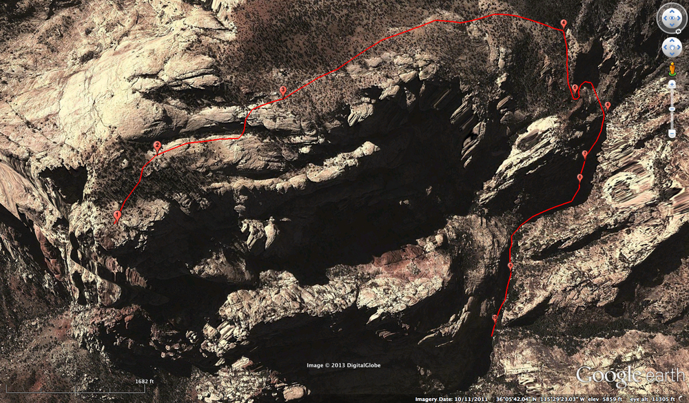 1. From the true summit of Mt. Wilson, with the Horseshoe Wall off to your left (SSE), contour down and south from the summit, eventually wrapping around to gain the first of a series of E-W slabs/gullies. |
|
|
https://www.gaiagps.com/public/lulR1CUlRpvBNgPVLR5dtxZc Sightly off route at the summit. Just zoom in on your gaia map and you'll see the trail outline. I was too busy developing the FDU scale to stay on route. The rest of the track is spot on. Gaia is your friend in Red Rocks. Edit to add: the .gpx listed above on the FKT website is accurate and done at an astonishing 2 hours and 9 minutes round trip from the oak Creek parking. I believe Sam did the descent in under 55 minutes on that run. (.89 FDU) |
|
|
Hi all. I spent a bit of time putting the various GPX I could find into caltopo and am now more confused. I _think_ the blue/green is the standard cleaver crack, and the red/orange are a variation. Can someone who has been up there chime in? Planning this as a solo scramble for this coming friday (arriving a day earlier than friends). Edit: OK I think I get it on further reading. Orange/green is "Oak Creek Canyon": https://www.summitpost.org/oak-creek-canyon/179873 Whereas green/blue is cleaver crack: https://www.summitpost.org/cleaver-crack/394684 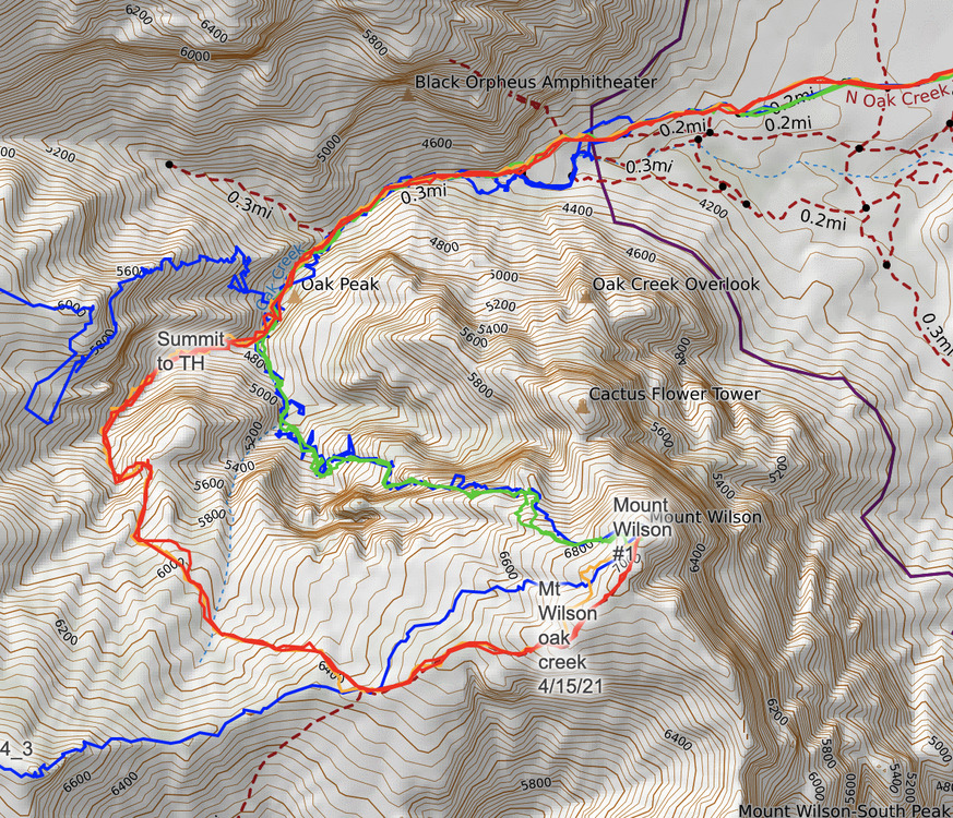 |
|
|
Follow the red. Green/blue to the north is cleaver crack. The blue and orange over lapping red are both slightly off route. The whole backside of the mountain is a giant low angle slab and there's many ways to go. Red is the standard |
|
|
Thanks! As a scramble rather than a descent I was imagining cleaver crack would be more fun. Harder route finding though presumably? |
|
|
The standard Wilson descent route is just walking with a few 4th class sections. Cleaver crack is more of a scramble (for maybe just a short few hundred feet) and yes more interesting. I've only done the actual scramble part once and it was on the descent. I remember a fixed line in terrible condition that probably wouldn't hold much more than body weight. I believe the climbing was no harder than 5.4 but that was 5.4, sandy, friction slab that I was onsight down-climbing with gear and a pack so it felt pretty heady. I think going up would feel a bit easier. This should be a beta overload: https://www.summitpost.org/cleaver-crack/394684 Edit: after reading the summit post beta, I was probably off route with the fixed line. The summit post make it sounds like there's a mega chill way to get past that section. Route founding will likely be the crux. |
|
|
Thanks a lot. Will see how fiesty I'm feeling on the hike in from the 159. And ha yeah, that summitpost beta is a labor of love for sure. |
|
|
You should save it on your GPS and reference it on your way down. Cleaver crack is cool, but can by tricky to locate. A bunch of cairns take you down towards oak creek, so you need to know when to turn right for cleaver crack. It’s impossible to get lost going down First Creek, but it’s a slog that way |
|
|
If you just want to have a fun day out scrambling and are comfortable on fourth and low fifth class then I highly recommend rainbow direct. It's the most continuous scrambling in Red Rock and the most fun for a climber, in my opinion. The view from the rainbow mountain is amazing and the descent out oak Creek is beautiful. https://www.summitpost.org/rainbow-direct/829824 If your goal is to get to the top of Wilson then I highly recommend you go up the White Rock gully to white rock pinnacle, hit up dead horse point then follow the ridge to the summit. The descent out of the hidden bowl is nice too, or follow the descent above in red. https://www.summitpost.org/white-rock-pinnacle-and-dead-horse-point/888903 |
|
|
Cassy did you ever nail down the descent? I went up cleaver crack and down the standard south fork descent a couple of weeks ago. Towards the top of cleaver route I found myself on the same 5.4 slab Thomas describes above with a fixed line in poor shape, definitely heady scrambling (but I wasn't gonna trust that line). Even after going up the cleaver crack route I am not sure if I could find the right spot to head down from the top. The south fork descent was pretty straight forward, though I did get suckered onto the big white slab near the top that is off route on the orange line shown above. For some reason there were cairns heading down that slab. In the south fork there are a couple of sections of downclimbing down slick waterfalls. There was one section on this with a fixed rope in good shape, but if you find yourself at this spot with no fixed rope you may want to rap. There's another section with hard looking scrambling down the waterfall with a "hike" around it, but I found myself making steep 4th class moves with bad fall potential. I think I was off route here too. While the south fork descent is pretty straightforward, I would hate to try and do it in the dark without knowing the route. GPX tracks were nice to have for reference. |
|
|
Ashort wrote: I went up cleaver crack and down the standard south fork descent a couple of weeks ago. Towards the top of cleaver route I found myself on the same 5.4 slab Thomas describes above with a fixed line in poor shape, definitely heady scrambling (but I wasn't gonna trust that line). Even after going up the cleaver crack route I am not sure if I could find the right spot to head down from the top. If you were by a fixed line on the top of cleaver you were off route, I’d guess you cut up too early. An exposed 4th class traverse is the crux of cleaver crack. |


