
 Continue with onX Maps
 Continue with Facebook


access to Mt Starr King?
|
|
Just wondering if it is possible to safely access the Mt Starr King area at the moment. I'm assuming Illilouette Creek is flowing torrentially from the snowmelt and will be for some time... Also have read somewhat conflicting information regarding the presence or lack thereof a bridge crossing the creek. I've never been to the area so would appreciate any advice! PS. On a related note I also heard this peak is unclimbable. Am I crazy to try it? My guidebook is written by some dude named Josiah so it's got to be pretty old. |
|
|
The standard route (SE saddle) its like 5.0. I brought rope and gear, but in retrospect it would easily be soloed if you wanted. Its a fun jaunt. A bunch of people climbed it over July 4th. Go for it, its a fun little climb. I climbed it last year, here is a link with some pics if that's helpful -- http://fresnoclimber.blogspot.com/2016/09/mt-starr-king.html Be sure to read to flip through the summit register. You'll be surpirsed by some of the names you find in there! |
|
|
Hey C Brooks thanks for sharing your trip, Starr King looks like a great time! Also very encouraging to hear people are climbin it already. My PS. note was a sad attempt at humor....haha. As I understand it Josiah Whitney proclaimed Half Dome and Starr King unclimbable during his tenure with the California Geological Survey. Just goes to show how imaginative climbers can be! Did you start from the Mono Meadows trailhead off Glacier Point Rd? Just want to get my approach beta correct as the conditions this year are unusual to say the least. |
|
|
update: We climbed the SE saddle route yesterday. As advertised, it was a lot of fun. Just wish it was a little longer! Camped on the mountain between the two lower bumps and caught some beautiful alpenglow action. Also...there are bats up there! At first I couldn't believe it, but there was fluttering and shadowy unusual flight patterns as the light faded, and then very distinct chirping. Would be cool if someone more ecologically oriented could confirm bats in the Sierra? Am I losin it? Found a Honnold entry in the register:  So he is an environmentalist, too?! My hero! hahahaha The Illilouette drainage was so quiet and peaceful. Didn't see anyone out there for almost two whole days. Neither of us have spent much time in Yosemite, so we took the Panorama Trail from Glacier Point and stood awestruck at the views. Great weekend. Here's a few pics for the air quality update... summit view from Starr King, early evening on Saturday: 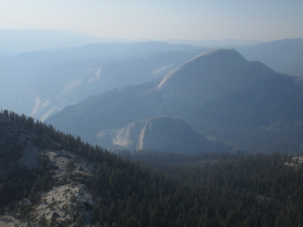 around noon today (7/23) heading back to Glacier Point: 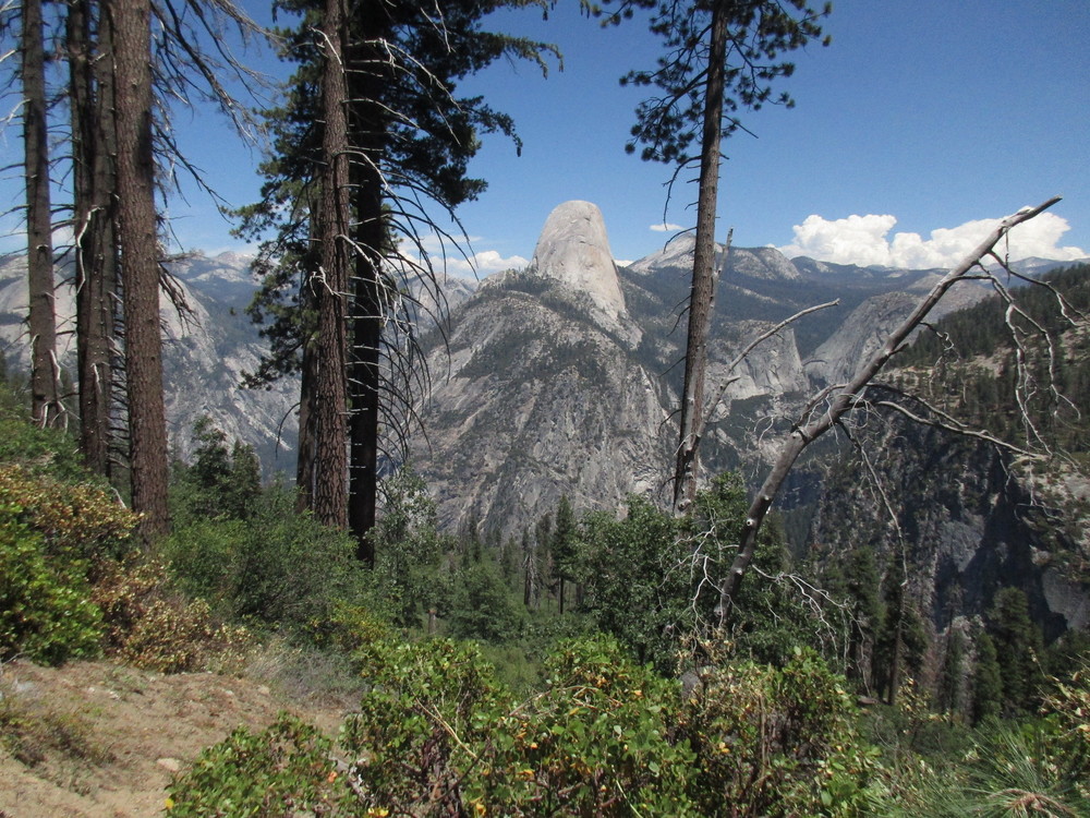 From the news sounds like the firefighters are kicking ass, so fingers crossed for more clear days like we had today! |

|
Yes, lots of bat species in the Sierra. That summit entry from Alex is classic. What a sprayer. :) |

|
Hi Hailman - sounds killer! I understand you took the Pano trail and so crossed the Illhouette drainage at the bridge, but did the water level seem manageable to cross up above from the Mono Meadows start? Also, if you're not against sharing beta, how far was your water source from your campsite? Thinking of taking our young daughter out that way, any info appreciated. |
|
|
Thanks splitclimber, I'll have to keep my ears open in the future for bat chirps. The great range continues to amaze...something new and unexpected on every trip...! Sirius, that is correct. We took the Panorama Trail and crossed the Illilouette on the bridge partly because we were worried about the stream crossing. However, we crossed a lot of dried up mini-stream channels on our southeastward journey toward Starr-King (on a trail about 250 feet above the Illilouette). Conditions seemed generally dry in the southern Yosemite backcountry. Given the dry conditions, we were relieved to find the stream shown on the USGS 7.5' topo originating from the two smaller domes of Starr-King to be flowing with water. We filled up all our bottles and camped at the saddle comfortably. We carried our water about 1000' up to camp, although you could probably find a spot to fill up higher. Here's some details: 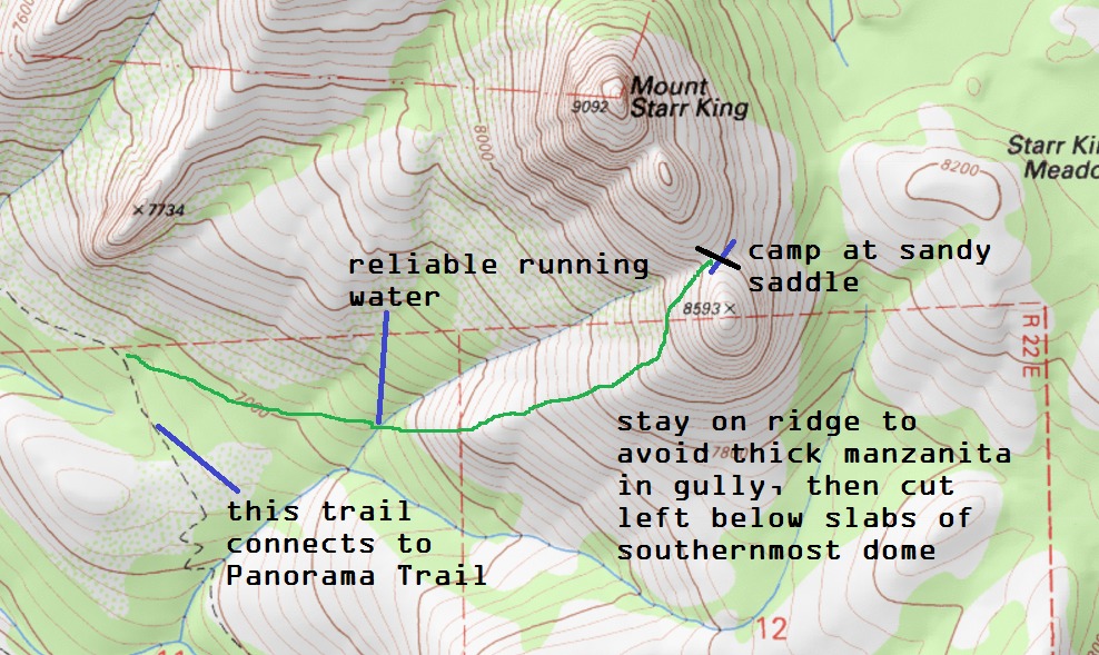 Considering all the dried up channels we saw, if I were to do the trip again I'd probably go for the Mono Meadows start. Here's a picture of the Illilouette at the Panorama Trail bridge crossing: 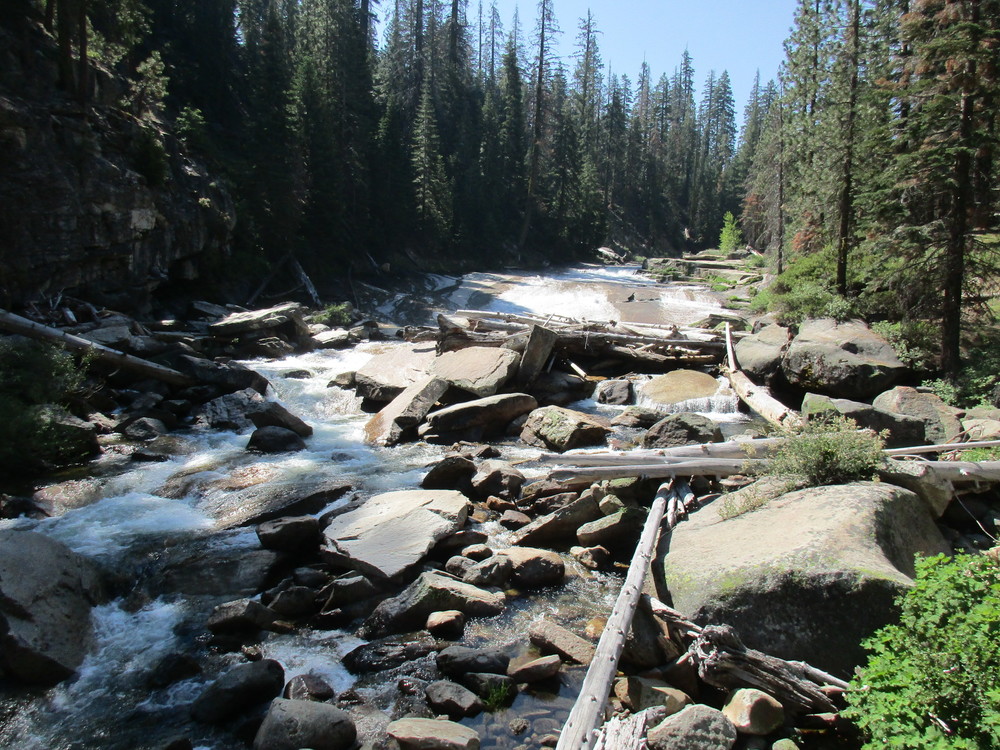 Hard to figure the flow rate since it's so slabby down there. For what it's worth we did have fun on the Panorama Trail. Here's the full trail connectors we took:  Have fun!! |


